HELLULAND: Land of Flat-rocks
MARKLAND: Land of Forests and Timber
VINLAND: A Warm and Bountiful Land -
"distinguished by self-sown wheat,
wild vines and trees called mosurr.
The dew there was very sweet;
salmon of great size abounded;
cattle could forage for themselves in winter,
for there was no frost and the grass barely withered ..."
(Tryggi J.Oleson, The Norsemen in America, The Canadian Historical Association Booklet No. 14, Ottawa, 1963:13).
1.
HELLULAND
Eirik
the Red's Saga
[Greenland, Helluland and
Markland]
That winter there was much discussion at Brattahlid [H : about searching for Vinland the Good, and it was said that it was a profitable country to visit]. They played draughts, told stories, and occupied themselves with other activities to pass the time. Karlsefni and Snorri wanted to set out and find Vinland, and the plans were discussed. They made their ship ready and wanted to sail to Vinland that summer [H : spring]. Bjarni and Thorhall also wanted to join the expedition with their ship and with the crew which they had brought with them.
There was a man by the name of Thorvald, the son-in-law of Eirik the Red [H: he came along, and also Thorhall, who was called 'the Hunter']; he had been with Eirik a long time as a huntsman and had been charged with the responsibility for many things. Thorhall was a huge, swarthy man who looked like an ogre; he was getting on in years, was bad-tempered and of few words, taciturn and cunning but nevertheless abusive in speech and always inciting [H : Eirik] to that which was evil.
He had cared little about the Christian religion since it had come to Greenland. Thorhall had few friends, yet Eirik had for a long time listened to his counsel. He was on board the ship with Thorvard [H: with Thorvard and Thorvald], for he had wide knowledge of remote regions. They had that same ship in which Thorbjorn had come to Greenland. Most of the crew were Greenlanders. Altogether there were a hundred and sixty men on board the ships.
First they sailed to the Western Settlement and from there to Bjarneyar. They sailed from Bjarneyar before a northerly wind and were at sea two days. Then they found land and rowed ashore in the ship's boats to explore it. They found there many flat slabs of stones that were so big that two men could easily stretch out on them sole to sole. [H: many of them were twelve ells (i.e. eighteen feet) across.] There were many white foxes there. They gave the land a name, and called it Helluland.
They then sailed for two days before a northerly wind [H: and changed their course from south to south-east] and then they saw a land ahead with large forests and many animals. South-east of the land there was an island, and there they encountered a bear and called the island Bjarney, Bear Island. The land with the forests they called Markland.
After two days they sighted land again and sailed in towards the coast [H: Then they sailed southward along the coast for a long time and came to a cape]. There they arrived at a cape; they sailed along the land and had it on their starboard side. It was an open harbourless shore with long sandy beaches. They rowed in to the shore and found [H: there on the cape] the keel of a ship and called the place Kjalarnes. They also gave a name to the beaches, calling them Furdustrandir ('Wonder Beaches'), because it took them so long to sail past them.
Then the coastline became indented with bays, and towards [H: one of] them they steered their ships. (Helge Ingstad, Westward to Vinland:The Discovery of Pre-Columbian Norse House-sites in North America, translated from Norwegian by Erik J. Friis, Macmillan of Canada, Toronto, 1969:52-53; emphases supplied)
1A.
BEAR ISLES AND BEAR ISLAND
With the above in mind there
are a number of ways that the location of Helluland might be
approached, starting with succinct directions provided Nicholas, Abbot
of Thingeyre as quoted by Joseph Fischer (The
Discoveries of the Norsemen in America with Special Relation to their
early Cartographical Presentation, Trans. Basil H. Soulsby,
Burt Franklin, New York, 1903:8-9), i.e.,
Greenland in the accepted
sense was left far behind;
nevertheless, the Greenland Dualities proposed earlier remain fully
applicable. In other words--conventional
views concerning the
"Eastern", "Middle" and
"Western" Norse settlements of modern Greenland notwithstanding--there
should exist a
corresponding set for Eastern, Central and Western North
America. Whether (at least initially) the Eastern
Settlement lies in the Ungava Bay region or much further south remains
debatable, as, no
doubt, does a presumed location for a Middle Settlement somewhere in
the
Central
Arctic (perhaps around Cambridge Bay?). As for an initial Western
Settlement
(or settlements), these
may or may not be found
close to Yakutat Bay in Alaska; embracing (perhaps) neighbouring Icy
Bay to the west and Haines further to the east--all more or
less along the 60th parallel with the last named also coinciding with
the top end of the line of the unexplained Pacific Northwest stone
cairns (see Maps 4c2 and 6d below).
Thus, after arriving at the "Western
Settlement" of
"Greenland" it will still be necessary to proceed to "Vinland" in accordance with all
the places, times, distances and directions given in
the
Sagas, i.e., initially by way of the plural "Bear
Isles,"
Helluland and Markland.
They then sailed away for the Western Settlement and for Bjarneyjar, Bear Isles. From Bjarneyjar they sailed with a north wind, were at sea two days, and then found land. They rowed ashore in boats and explored the country, finding many flat stones there, so big that a pair of men could easily clap sole to sole on them. There were many arctic foxes there. They gave the land a name, calling it Helluland, Flatstone Land. Then they sailed with a north wind for two days, when land lay ahead of them, with a great forest and many wild animals. Off the land to the south-east lay an island, where they found a bear, so called it Bjarney, Bear Island. But the land where the forest was they called Markland, Wood Land.(Gwyn Jones. The Norse Atlantic Saga: Being the Norse Voyages of Discovery and Settlement to Iceland, Greenland, and America. Oxford, Oxford University Press, London 1964)On the other hand, in the Hauksbok Version it is stated that:
They set sail for the Western Settlement and from there to Bjarney, Bear Isle. From there they sailed south for two days and then sighted land. They launched their boats and explored the countryside, finding huge flat stones there, many of them twelve cells across. There were large numbers of arctic foxes there. They gave the land a name, calling it Helluland. Then they sailed onwards for two days and changed course from south to south-east, and found a land heavily forested, with many wild animals. Offshore to the South-east lay an island. They killed a bear on it, so called the island Bjarney, Bear Island, and the land Markland. (emphases supplied)Thus a contradiction between the two versions. But then again, if such encounters resulted in Islands being named after a single bear (or bears in the plural) there would surely have been a requirement to differentiate between the two. Thus as far as the above references are concerned it might be more useful to the remain with the first and dwell upon the second later.
1. Admiralty Island. (Alaska) off the southeast coast of Alaska with the largest concentration of Alaskan Brown Bears in the World.The first selection is therefore noteworthy for its bears, but hardly isolated from the surrounding islands by it. Then again, the selection of Admiralty Island also permits the inclusion of the Pacific Northwest's unexplained stone cairns; specifically, the pair on the south-east side of the island near the junction between hypothetical outer and inner passages discussed earlier in "Symbols, Markers and Indicators" :
2. The Queen Charlotte Islands (QCI, British Columbia). The home of the world's largest Black bear; seen at times foraging along shorelines.
Map 6d. Unexplained Pacific Northwest Cairns; Outer and Inner routes to Helluland and Markland
1B.
THE FLAT ROCKS OF HELLULAND
Assuming that Admiralty Island is indeed the primary
indicator for "Bear Isles" what next? One way would be to follow the
Stone Cairns and the instructions in the Sagas, which require two more
days sailing due south. Here, of course, the sailing would have to take
place among the islands of the Alexander Archipelago, but the main
Channels leads south readily enough. But two days sailing from
Admiralty Island? Difficult to say since the island itself is quite
large and it is not clear whether the voyage commences at the northern
or southern end, or whether one should remain on the eastern or western
side of the Island . But either way the direction will still take us
south and also connect up with further stone cairns along the way.
But still bearing all this in mind, the quickest and most
direct method would still
perhaps be to operate on the assumption that the petroglyph
approach is valid and pay attention to their distribution in the
Pacific Northwest, i.e.,
From the rock paintings of the Chugach Eskimo of Prince William Sound to the next known examples in southeastern Alaska near Sitka, there is a distance of approximately 450 air miles. Doubtless there are more examples between these points that may be recorded in the future but much of the intervening country is covered with glaciers and heavy forest where inconspicuous rock carvings might well go unnoticed. This is Tlingit territory and the carvings occur on Wrangell and several adjacent islands. A complex arrangement of figures carved on a boulder near Sitka was interpreted by an elderly Tlingit as a representation of the creation myth. This legend is common to all Northwest Coast tribes and indeed in various forms is found throughout North America. According to this legend, in the beginning the world was a confused mass of rock and ocean, enveloped in darkness and controlled by powerful spirits who possessed the elements necessary to human life. Yehlh, a benign spirit, who could assume any shape but particularly that of a raven, created man. Over the strenuous objections of the other spirits, he was able to give his children light, fresh water, fire, air, and other good things. After all was done, he disappeared.Thus skip the distinct gap east and southeast of Kodiak Island and plump straight for the next occurrence of petroglyphs to the south, or better still, go directly to where the line from the Admiralty Island stone cairns and the next petroglyph area intersect, which is in fact in the vicinity of Wrangell and Etolin Islands. Not only that; the petroglyphs in question are also depicted on flat rocks, some of which are indeed large. At which point the information in the Sagas concerning Helluland becomes more pertinent, i.e.,
On Etoline Island, at about high-tide level, there are many smooth dark rocks, seldom over three feet in diameter, with single figures carved on them. The designs are chiefly animal motifs and represent totemic or clan symbols of the Stikine tribe. There are highly stylized drawings of the wolf, bear, raven, shark, killer whale, eagle, and human head, both outlined and without outline. On Wrangell Island to the east, there are similar carved beach boulders, some with fantastic marine beings referred to by the local Indians as sea monsters. (Grant 1967:83; emphases supplied)
Eirik the Red's SagaWhat was it about the latter that was both representative and significant enough to stress in the Sagas? Perhaps some may say that it is pure coincidence, but this is was what is left among the horizontal petroglyphs at Wrangell Island -- a magnificent spiral, a sunburst and a stylized outlined face on a flat rock visible at low tide (see Figures 2c and 2d for three larger, more general examples):
:... they sailed to the Western Settlement and from there to Bjarneyar. They sailed from Bjarneyar before a northerly wind and were at sea two days. Then they found land and rowed ashore in the ship's boats to explore it. They found there many flat slabs of stones that were so big that two men could easily stretch out on them sole to sole. [ H: many of them were twelve ells (i.e. eighteen feet) across. ] There were many white foxes there. They gave the land a name, and called it Helluland. (Helge Ingstad, 1969:53: emphases supplied)

Fig. 7-2a. The Flat Rocks of Helluland I
The Spiral, Sunburst and Petroglyphs of Wrangell Island, Alaska. (G.T. Emmons)

Fig. 7- 2b and 7- 2c. The large Flat Rocks of Helluland II and III
Bella Coola River petroglyphs. (National Museum of Canada)
Fig. 7- 2d. Larger Flat Rocks of Helluland with Spirit Face: (Bella Coola Region)
(National Museum of Canada)
That many petroglyphs are extremely ancient is indicated by the fact that the majority are located on beaches at half to low tide levels. Others, as at Port Neville, Fort Rupert, and Return Passage at Bella Bella, are located on bedrock at the same tide levels. That is to say, these carvings are submerged at high tides. Carvings so located are to be found from BC southward into Washington. It is difficult to imagine an ancient petroglyph carve for extreme low tide in order to begin his work, and be constantly interrupted by the rising tides, while, close by, other surfaces well above the high tide reach offered good opportunities for carving. It is more reasonable to believe the surfaces on which he worked were, at the time, situated above high tide level. This could only mean that at the time these carvings were done, the sea level, in relation to the land was considerably lower than it is at present. In most places a difference in tide level of at least twelve feet would be to allow the carvings to stand above the high tide mark. This leads us into a study of the surficial geology of the Pacific Coast, a subject on which little investigation has been done to date. However, so far as is known at present, it is probable that the sea level was, in most coastal places, some fifteen feet lower than present, about eight thousand years ago. One strongly hesitates to place the age of any of the glyphs that far back, however, and there is some believe that world tidal fluctuations two, three and thousand years ago resulted in somewhat lower tide levels on the Northwest Pacific Coast, from which time the tide risen regularly in infinitesimal degrees. Possibly some petroglyphs were carved during one of these fluctuations. In many places the possibility must be considered that erosion of shorelines has undermined the carved boulders and lowered them to the beach at present tide levels. Shoreline erosion has always been a factor, and at places such as storm-beaten Cape Mudge, it continues at a rapid pace. Yet in instances where petroglyphs have been carved on bedrock at low tide level, one can only conclude that the petroglyphs were done at existing tide levels, or that tide levels were substantially lower when the carvings were done.Thus even here matters are not that straightforward. However, including the need for secrecy (at least initially) the below tidal limits approach would be quite effective; anyone pursuing would likely sail right on by oblivious at higher tidal levels, whereas those who had been familiarized with the situation would not only know what to look for, but also when and where. But even so the matter can hardly rest here, given the numbers of horizontal petroglyphs and their distribution throughout the Pacific Northwest.
2. MARKLAND
Eirik
the Red's Saga:
First they sailed to the Western Settlement and from there to Bjarneyar. They sailed from Bjarneyar before a northerly wind and were at sea two days. Then they found land and rowed ashore in the ship's boats to explore it. They found there many flat slabs of stones that were so big that two men could easily stretch out on them sole to sole. [H: many of them were twelve ells (i.e. eighteen feet) across.] There were many white foxes there. They gave the land a name, and called it Helluland.
They then sailed for two days before a northerly wind [H: and changed their course from south to south-east] and then they saw a land ahead with large forests and many animals. South-east of the land there was an island, and there they encountered a bear and called the island Bjarney, Bear Island. The land with the forests they called Markland.
After two days they sighted land again and sailed in towards the coast [H: Then they sailed southward along the coast for a long time and came to a cape]. There they arrived at a cape; they sailed along the land and had it on their starboard side. It was an open harbourless shore with long sandy beaches. They rowed in to the shore and found [H: there on the cape] the keel of a ship and called the place Kjalarnes. They also gave a name to the beaches, calling them Furdustrandir ('Wonder Beaches'), because it took them so long to sail past them.
Then the coastline became indented with bays, and towards [H: one of] them they steered their ships. (Helge Ingstad, 1969:53; emphases supplied)
2A.
KEELS AND KEELNESS
Taking cues from the Stone Cairns, the Flat Rocks,
and the reasonable assumption that the route leads southward, one could
leave the Wrangell/Etolin Islands area and proceed via Clarence Strait
down the west coast of the latter and the east coast of Prince of Wales
Island.This route would firstly lead past the Stone Cairn on Etoline
Island and
next past Cleveland Peninsula and the Stone
Cairn above Union Bay in Ernest Sound before
passing Annette Island at the bottom of the Strait. Beyond this lies
open water and a direct route south to Rose Point on the Queen
Charlotte
Islands' Graham Island. Alternatively, one could proceed due west
from the top of Wrangell Island and then turn south, proceeding down
the western side of Prince of Wales Island (which might also be a prime
location for another stone cairn, perhaps near Copper Mountain on the
southern part of the Island - also a good vantage point for the
way South). In any event, the last route would lead past Noyes, Lulu
and
then Dall Island, or wider still, Forrester Island. Beyond here again
lies
open water, but this time farther out into the Pacific, with Markland
perhaps to the south (or the southeast in the case of Forrester
Island). As for the time intervals involved, i.e., "two days sailing,"
doubts have been expressed by some regarding the degree of precision
that can ever
be applied to such statements, although Helge Instad (1969:36) based
his
own estimates on practical considerations and arrived at 120 nautical
miles per 24-hour day. This of course applies to open water; how much
modification results from operating in more confined channels is open
to debate, and clearly rowing factors as well as prevailing winds and
weather need to included here. But certainly in the present context the
Sagas refer to sailing due south, i.e., aided by a north wind which
simplifies matters somewhat. And then again the steps from the Lynn
Canal to Admiralty Island, from the latter to Wrangell Island and from
there to Markland
might all be reasonable goals for two days "sailing" in favourable
winds
if combined with strong arms and equal determination. (see Map 5a below).

OUTER ROUTE: THE "WESTERN SETTLEMENT" TO HELLULAND I
Yakutat to Sitka, Alaska: 235 miles
Sitka to Cape Knox, QCI (NW tip of Graham Island): 218 miles.
OUTER ROUTE: THE "WESTERN SETTLEMENT" TO HELLULAND II
Yakutat to Cape Edgecumbe, Alaska: 226 milesOUTER ROUTE: HELLULAND TO MARKLAND I
Cape Edgecumbe to Cape Knox, QCI (NW tip of Graham Island): 223 miles
INNER ROUTE: HELLULAND TO MARKLAND
Wrangell Island to Rose Point, QCI (NE tip of Graham Island): 175 miles
Wrangell Island to Sandspit QCI (NE tip of Moresby Island): 225 milesOUTER ROUTE: HELLULAND TO MARKLAND II
DIRECT ROUTE: MARKLAND TO VANCOUVER ISLAND
Wrangell Island to Cape Knox, QCI (NW tip of Graham Island): 210 miles
Wrangell Island to Rose Point QCI (NE tip of Graham Island): 250 miles
Sandspit, QCI to Cape Scott (NW tip of Vancouver Island): 225 miles
Sandspit, QCI to Bull Harbour (off the NE tip Vancouver Island): 230 miles.
However, from Part 8
(South
by Southeast) by backtracking from the information provided in the
Sagas and the suggested location of Vinland itself (i.e., Cowichan Bay and environs in
the southeast corner of Vancouver Island, BC) it proved feasible to
determine the locations, routes and also the distances between all
three
Viking
"lands" as shown in Map 4h.

To continue the journey southwards once Markland has been reached it appears that one is required to be sailing with land (or the east coast of an island) on the starboard side, i.e., to the right facing and traveling south. The first thing encountered are beaches, beaches noteworthy for their extent and the time required to pass them - indeed, called "Wonder Beaches" on account of this. Presumably the latter run from north to south in keeping with the predominant sailing direction for this particular segment of the voyage. Anyway, sailing either due south from Clarence Strait (or due south then southeast according to the option suggested above) one might well obtain a landfall at Cape Knox on the western tip of Graham Island in the latter case, or Rose Point in the former; i.e., the NW and NE tips of the Queen Charlotte Islands (Haida Gwai). Based on what was noted before, however, i.e., the statement:
Then they sailed onwards for two days and changed course from south to south-east, and found a land heavily forested, with many wild animals. Offshore to the South-east lay an island. They killed a bear on it, so called the island Bjarney, Bear Island, and the land Markland.one might suggest that in this version of the Sagas the outer route is indicated and that the approach was from the northwest, which would be more in keeping with open sailing as opposed to negotiating the straits and passages between the islands. Either way, however, from here on to conform to the Sagas one must proceed south down the eastern side of the island; sound advice, as anyone who has sailed this region can no doubt attest, since it provides protection from the winds, swells and weather streaming in unchecked across the Pacific Ocean. But in any event, now that we have arrived at the Queen Charlotte Islands (QCI) now Haida Gwai) how, for a start, does the reference to a "a land heavily forested, with many wild animals" compare with the flora and fauna of this large and relatively isolated archipelago? Quite well, it would seem, as the following from Queen Charlotte Island Tours attested
The Queen Charlotte Islands ... consist of about 150 islands, the two largest being Graham Island to the north and Moresby Island just south of it. This magnificent area has a unique geology. It is fed by the Japanese current which gives it a climate similar to that of Vancouver, British Columbia. The whole area is saturated with many fascinating bird species, marine life and wildlife. Species which may exist in marginal numbers elsewhere are very plentiful in these islands. This is, perhaps, in addition to the unique rock formations, the first characteristic the newcomer experiences. Examples would be the migrations of gray whales during Spring and early Summer, the presence of the largest black bears of North America, the largest type of turtle in the world and the plentitude of bald eagles and ravens. The area is sometimes referred to as "the Galapagos of the North" ..." ( http://www.queen-charlotte-islands-tours.com/birdwatching.htm ):The forests will be deferred until later, but first, "Keelness" also enters into the present discussion, for as Helge Instad states in his description of this part of the voyage:
They met with rough weather outside a cape, the ship's keel was broken, and they had to repair the ship. They called the cape Kjalarnes, or Keelness. In the account of Karlsefni's expedition (Eirik the Red's Saga) there is also mention of a Keelness, but it has an entirely different location, namely, on the extensive beaches of Markland, about two days' sailing to the north of Vinland. (Helge Ingstad, 1969:64)As ever the differences between the various versions of the Sagas intrude, even without the dualism that may also be suspected, but the second reference appears to be a possibility in our present context. But either way, approaching the northernmost tip of the Queen Charlotte Islands from the northwest one could well run into serious problems, especially in bad weather. Thus it would not be difficult to imagine the problems a light wooden ship would have approaching this particular coastline. But is the northwest tip of Graham Island one of the "Keelness" locations? It is hard to say, of course, but there remains one further point concerning the resumption of the voyage after the ship was repaired. According to Thorvald Eiriksson's Vinland Voyage they then sailed eastward and:
Afterwards they sailed away from there and eastward along the land and into the nearest fjord mouth and to a headland which was jutting out there. It was completely covered with woods. There they moored their ship and put out the gangway to the shore, and Thorvald went ashore with his entire crew. Then he said: 'This is a beautiful place; here I should like to make my home.' (Helge Ingstad, 1969:44)To the east of Cape Knox there are in fact two likely entrances - Naden Harbour and Masset Inlet - see Map 5b below.
Since its discovery and acquisition by Yale University, the famous map on the facing page has revived bitter controversy on both sides of the Atlantic as to who first discovered America, the Vikings or Columbus. The argument has become emotional, and spread from the scholars to ordinary people of Norse or Latin descent, thus obscuring the rational arguments for and against the map's validity. The map is said to be an authentic attempt, made half a century before Columbus sailed, to depict the North Atlantic, and shows Vinland, with the words: "Island of Vinland, discovered by Bjarni and Leif in company." However, the authenticity of the dating of the Vinland map has been challenged on several grounds. It is suspicious that Greenland should be shown with so much accurate detail at so early a date (unless this is coincidence), while the British Isles and Scandinavia are so ill depicted. It is also strange that the map does not mention either Helluland or Markland - the latter, in particular, must have been important as a source of timber to the Greenlanders who first came to America. Despite these discrepancies the map is based on well-known traditions of the Vinland voyages. Whether it was really created before Columbus or afterwards, however, is very difficult to determine. In any case, it does not prove or disprove the prior Norse discovery; it shows only the map-maker's familiarity with this Norse tradition, the validity of which some scholars question. (Bertil Almgren et al. THE VIKING, AB Nordbok, Gothenburg 197:66).The "Vinland Map" will not be dealt with here in detail nor will any lengthy discussions ensue concerning its questionable authenticity, except to suggest that if anything the "Vinland" part of the map in its present state bears a better resemblance to the Queen Charlotte Islands than just about anywhere else - Newfoundland included. As for Helga Ingstad's so-called "discovery" of the Viking site at L'Anse aux Meadows in the early 1960's, even this is fundamentally false, as Farley Mowatt pointed out in 1965, when he noted in Appendix N in his thorough and detailed examination: WESTVIKING:The Ancient Norse in Greenland and North America:
The story of the discovery of the ruins at Epaves Bay ( L'Anse au Meadows ) begins in the years before the First World War, when Mr. W. A. Munn of St. John's, Newfoundland, became interested in reconstructing the western voyages of the Norse. Munn devoted many years to the project and published his conclusions in 1929 (Wineland Voyages. Location of Helluland, Markland and Vinland. St. John's). He believed that one or more Norse expeditions must have camped either in Pistolet Bay or Sacred Bay at the tip of the Great Northern Peninsula of Newfoundland. Although he thought Pistolet Bay might be the best place to look, he did not overlook Sacred Bay, and in correspondence as well as on the map accompanying his published study, he specifically indicated the Epaves Bay area. [ Map: “Sacred Bay” ] Influenced to a degree by Murm's conclusions, the Finnish geographer Dr. V. Tanner, who worked in Labrador and Newfoundland from 1937 to 1939, suggested that the Karlsefni expedition had probably built its Straumfjord base in this region.Thus from the above it is clear that indications of a Viking settlement in the region extend back to at least the 1920's, if not earlier. Also, Helge Ingstad's work commenced in 1961, i.e., before the publication of the "Vinland Map" in 1965. Thus the latter is of no real value in the determination of a Norse presence in North America at all. In this respect it is simply unnecessary, though it does reinforce the far from certain suggestion that Vinland is the Viking site at "'Anse aux Meadows." Coming on the scene after the discovery of L'Anse aux Meadows, the "Vinland Map" simply serves to not only close the door on the subject, but also rivet and limit attention to this eastern extremity rather than expanding the search to the North, to the Interior, and to the West.
In the early I950's an amateur enthusiast named A. H. Mallery took up these suggestions and made a fruitless search of Pistolet Bay. However, no proper investigation was attempted until 1959, when the Danish archeologist Jorgen Meldgaard visited the area and, assisted by a local man, made an extensive search. Meldgaard satisfied himself that there were no Norse sites in Pistolet Bay, but by that time the season was too far advanced to allow him to explore Sacred Bay, and he returned to Denmark. Before leaving he instructed his assistant to spread the word of what he was looking for among the local residents, and to inform him if anything turned up. The following summer Helge Ingstad, a Norwegian author who had been looking for Vinland on the New England coasts, visited the area. He too wished to search Pistolet Bay but was informed by Meldgaard’s companion of the previous year that there was nothing there. However, [p.452] during the winter the assistant had asked many local people if they knew of any old ruins, and his brother-in-law, George Decker of L'Anse au Meadows, had said he believed he knew where an "old Viking place" might be located. When I talked to George Decker in 1963 he told me that the interest shown by Meldgaard had prompted him to take a closer look at some faintly outlined house ruins on one of his fields at Epaves Bay. It struck him that this "might be what the Danish fellow was after." When Decker was approached by Ingstad, whom he at first took to be a Dane and an associate of Meldgaard's, he willingly guided him to the spot. ... In 196I Ingstad began excavations at Epaves Bay which were concluded in the summer of 1963.
No final decisions can be made about the origins of all the structures at Epaves Bay until the Ingstad expedition releases the full results of its work. At the moment there seems to be no good reason to deny the likelihood that some of the structures were built and inhabited by Norsemen of circa A.D. 1000 but it seems obvious that the large house was actually a shore whaling establishment of the early colonial period.
Although it has not been stated as a fact, the leaders of the Ingstad expedition have strongly intimated that the Epaves Bay site was the location of Leif Eriksson's Vinland. This deduction is not consistent with the facts as I understand them and as I have set them out in this book. If we are to accept Epaves Bay as Leif's Vinland we must discard, or seriously distort, the description of Vinland given in the Greenlanders Story -- and this is the only description of Vinland that we possess.
It is my belief that Epaves Bay was the site of a temporary Norse settlement established there by the combined Icelandic-Greenlandlc expedition led by Thorfinn Karlsefni and Thorraid Eriksson.
(Farley Mowat, Appendix N, The Epaves Bay Site, WESTVIKING: The Ancient Norse in Greenland and North America, McClelland and Stewart, Toronto 1965:450-51)
2B.
WONDER BEACHES
Continuing on our way then, after reaching Rose
Point and proceeding south down the east coast of Graham Island
- the first major section of
the Queen Charlotte Islands - what does one find?
Sixty miles of impressive beaches stretching south, lowlands to the east and mountains to
the west, as Anthony Carter's 1986 thumb-nail description of the Queen
Charlottes attests:
THE QUEEN CHARLOTTE ISLANDS are approximately 180 miles long and 60 miles wide at the widest point which is from Rose Spit to Langara Island. The average annual rainfall is 60 inches with the lowest amount of 37 inches falling at Sandspit Land elevation ranges from 4000 foot mountains on the west coast to a few feet of grassy bank on the east side of the island... Some of the finest sandy beaches in the world are to be found along the northeast shores of these islands. (Anthony Carter, THIS IS HAIDA , Agency Press, Vancouver 1968:137)Happily enough, this north-eastern part of the Queen Charlotte Islands is now preserved as Naikoon Provincial Park. The brief description that follows here is from BRITISH COLUMBIA TOURISM:
From Rose Point, or "Naikoon" as it was called by the Haida, at the northeast tip of Graham Island, largest of the Queen Charlotte Islands, broad, sandy beaches seem to stretch endlessly to form the eastern and northern boundaries of this unique and intriguing park. The park occupies part of the Hecate Depression, a trough between the Outer Mountains to the west and the Coast Mountains on the mainland to the east. The park is largely low and flat. Most of its topographic features are formed by underlying glacial deposits. In the northeast corner, Argonaut Hill, the highest point in the park, rises only 150 metres above sea level. Tow Hill, an outcrop of basalt columns, is a prominent landmark about 100 metres high on the north beach. Almost 100 km of beaches is the primary attraction for visitors. (emphases supplied)A prime candidate for "Wonder Beaches" - long sandy beaches on an eastern shore that stretch southwards for sixty miles...
2C.
BEAR ISLAND
Another local feature according to the Sagas was the
occurrence of a "bear" again, this time in the singular, apparently
used to separate Markland from the "Wonder Beaches." On a related note
it is useful to recall the following part of Helge Ingstadt's summary
of later voyages in search of Vinland:
In 1516 the Norwegian archbishop Erik Valkendorf planned an expedition to Greenland, and for that purpose he took steps to collect information about conditions in that far-away land. In his notes we are told that there were black bear and marten in that country. A similar and quite independent piece of information appears in a work by Absalon Pedersen Beyers in 1567.- He relates that in Greenland there were sable, marten, deer, and huge forests; but none of these are, in fact, found in Greenland, and the black bear is not even to be found in Norway in 1516 the Norwegian archbishop Erik Valkendorf planned an expedition to Greenland, and for that purpose he took steps to collect information about conditions in that far-away land. In his notes we are told that there were black bear and marten in that country. A similar and quite independent piece of information appears in a work by Absalon Pedersen Beyers in 1567.- He relates that in Greenland there were sable, marten, deer, and huge forests; but none of these are, in fact, found in Greenland, and the black bear is not even to be found in Norway.(Helge Ingstad, 1969:95)But as far as black bears on the Queen Charlotte Islands may be concerned, it is enough here to include a few words from a past internet travel brochure on these Islands by Bluewater Adventures. Their General Trip information for Haida Gwaii informed the reader under the heading LAND ANIMALS, that:
"The Queen Charlotte Islands black bear is the largest black bear in the world. We often see them foraging along the beaches from the boat." (emphases supplied)
Not just a black
bear, it seems, but the largest
black bear in the world that, significantly, is also occasionally
spotted from the ocean. Thus a special bear on a special island and the
kind of differentiation than an acute observational approach to nature
might well provide. The second "Bear" island of the
Sagas? (For more on these special bears, their environment and
the verdant Queen Charlotte Islands, see Page 8 of Great Canadian
Parks' Gwai
Haanas National Park.)
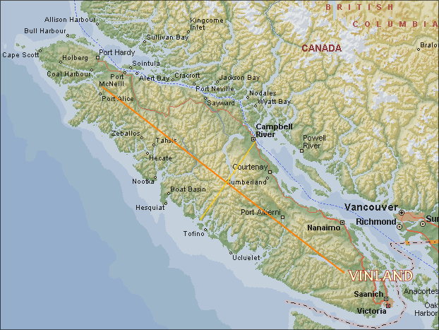
Finally, Map 5 below. Here the reader is directed in particular to Rose Point at the north-eastern tip of Graham Island (the northernmost of the two major islands of the group). This is the natural arrival point after proceeding south from Wrangell (Helluland) by taking the most direct and southerly route available. For this route, which also passes the last pair of unexplained Pacific Northwest cairns at Etoline Island and the Cleveland Peninsula, the sailing distance is approximately 175 miles. The outside passage - a route that requires a final change in course from south to south-east after Forrester Island - is correspondingly 250 miles, thus both within the two days sailing time stipulated in the Sagas; the former route shorter but more restricted, the latter longer but with more open water.
Thus commencing with
the route directly south from Wrangell, it turns out that the
information in the Sagas is not only acute, it is also readily met (see
Map 5 below); i.e.,
"After two days they sighted land and sailed in towards the coast. There they arrived at a cape".
Thus an arrival at
Rose Point, where
the latter (in a rather convoluted way) is associated with Naikoon
Provincial Park, i.e., the
Park "gets its name from a corruption
of the Haida term for 'long nose,' which was the Haida name for Rose
Spit, one of the most prominent features in the park."
Thus another name,
another prominent feature, albeit by non-Vikings.
To resume, having
arrived at Rose Point, then by
continuing south down the coast, naturally enough:
"they sailed along the land and had it on their starboard side".
From here matters tighten
up again, for although seemingly innocuous, the statements that follow,
e.g.,
"It was was an open harbourless shore with long sandy beaches.
are nevertheless loaded.
With its many mountains,
rivers and small islands, a long, open harbourless coastline is relatively rare in British Columbia. But it certainly occurs from
Rose Point
southwards for many miles. Moreover, the coastline also begins to open
up
with bays near the Queen Charlotte-Sandspit region at the bottom of
Graham Island, again as stated in the Sagas ( "Then the coastline
became
indented with bays.").
Lastly, the naming
of the
salient feature in this instance, i.e.,
They also gave a name to the beaches, calling them Furdustrandie ("Wonder Beaches") because it took them so long to sail past them.
not only reinforces the route
south and
the selection of the "Wonder Beaches" and "Bear Island" (in the
singular), but also Markland, land named for its wood, timber and/or
forests.
Thus as described above and shown
below:
GRAHAM ISLAND / MORESBY ISLAND of Haida Gwai (Queen
Charlotte Islands), British Columbia provides the location for "Wonder
Beaches," Bear Island, and in no small way the land of forests and
timber: MARKLAND:

Next, the Timber...
2D. MARKLAND
Thus HAIDA GWAI (the Queen Charlotte Islands) - the
home of the
Haida, a land of plenty, including forests and also timber - timber
enough to impress anyone on earth, let alone Vikings who had traveled
hard and long across
the treeless arctic.
And who more fitting and qualified than the
late Bill Reid [1920-1998], renowned Haida artist, carver and
naturalist to speak for Haida Gwai, Gwai Haaness and the region in
general on
this very subject.
Bill Reid then on the timber of the region - the history, the heart, and the soul of it:
Then there was the Forest.Then there is British Columbia's semi-mythical "Cary Fir" to be considered - all 417 feet of it. So immense, it seems, that its very existence was described by Todd Carney in The Raincoast Chronicles (1972) as a myth that:
Nowhere else was there anything like the Douglas fir, the strongest, toughest,
in many ways most remarkable wood in the world. Trees six, eight, twelve feet through the butt,
forty or fifty feet to the first limbs, two or three hundred feet tall. They are nearly all gone now,
but for a while they provided the beams and upright siding for half the houses of America,
and supports for many big buildings.
But to be used, they had to wait for the White Man, and his steel axes and saws.
They were just too tough and hard and heavy for the stone axe and wooden wedge.
The Spruce and the Hemlock were splintery and hard to work and weathered badly.
So a richness in timber lay untouched and useless till the White Man came.
If this had been all, these people might have degenerated to simple dependence on food resources.
But there was the cedar, the West Coast Cypress,
growing huge and plentiful in swampy areas around creeks and rivers.
Oh, the Cedar Tree.
If mankind in his infancy had prayed for the perfect substance for all material and aesthetic needs,
an indulgent god could have provided nothing better.
Beautiful in itself, with a magnificent flared base tapering suddenly to a tall,
straight trunk wrapped in reddish brown bark, like a great coat of gentle fur, gracefully sweeping boughs,
soft feathery fronds of grey green needles. Huge, some of these cedars, five hundred years of slow growth,
towering from their massive bases. The wood is soft, but of a wonderful firmness.
And, in a good tree, so straight-grained it will split true and clean into forty foot planks,
four inches thick and three feet wide, with scarcely a knot.
Across the grain It cuts clean and precise. It is light in weight and beautiful in color,
reddish brown when new, silvery grey when old.
It is permeated with natural oils that make it one of the longest lasting of all woods,
even in the damp of the Northwest Coast climate.
When steamed it will bend without breaking.
It will make houses and boats and boxes and cooking pots.
Its bark will make mats, even clothing.
With a few bits of sharpened stone and antler, and a lot of time, with later on a bit of iron,
you can build from the cedar tree the exterior trappings of one of the World's great cultures...
(Bill Reid, OUT OF THE SILENCE, Harper & Row, New York 1971:41-63.)
seems to demonstrate man's reach to embody with the belief of his blood, the massively dense, the somehow gentle yet demonically intense sheer growth potential of such a rainforest as is found on B.C.'s west coast.For the complete text and the controversy concerning this tree of trees, see: "A Fir Tree of the Mind"
In 1625 an Icelander called Biorn Jonsson who had borrowed Hauksbok (one of the two main manuscripts of Eirik's Saga) added a little note about Markland 'From the innermost shores of Markland comes driftwood. Markland is so called because of its dense forests.' (Magnusson and Pálsson, 1978:28; emphases supplied)Thus from the first quotation we have a pair of inter-meshing Markland qualities, and from the second,"the bays of Markland" with both recorded in Vinland-related Norse documents. However, in addition to Markland's "dense forrests" we now find further emphasis placed on "driftwood." But so what, one might counter, driftwood is found all over the Pacific Northwest coast. This is true enough. But then again, the driftwood along the shorelines of "Markland" (Haida Gwai) is to say the least, exceptional. And, as it so happens, especially in the region around and south of Rose Point, which is indeed on the "innermost shores" of Haida Gwai's Graham Island.
While Joseph Fischer adds a variant that links "driftwood" to "the bays of Markland:"
The Book of Hauk gives a full description of the preparation and preservation of seal blubber, and lays due stress on the point, which was of such importance to Greenland, that the northern country takes all “the drift-wood, which comes down from the bays of Markland.” (Joseph Fischer, The Discoveries of the Norsemen in America with special relation to their early cartographical Representation. Translated from the German by Basil H. Soulsby, Burt Franklin, New York 1903, Reprinted, 1970:33; emphases supplied)
[ THE EAST COAST TRAIL ]ending, as all good travelogues should, with a desire to revisit by writers and readers alike. One of these days ...
This is not the famous West Coast Trail, nor its sister trail the Juan de Fuca, but the lesser known East Beach Trail. The East Beach Trail stretches 90 km along the east coast of Graham Island, the largest of the Haida Gwai, or Queen Charlotte, Islands. At its north end is the world-famous ecological reserve Rose Spit, which juts 10 km into Hecate Strait reaching towards Alaska. From Tlell near the south end of East Beach, to Rose Spit at its north extremity, is a 90 km wild beach hike, known simply as the East Beach Trail. Beyond Rose Spit you must continue on the coast along North Beach to reach road access near Tow Hill, an intriguing outcrop of basaltic columns formed from volcanic rock about two million years ago.
North Beach is a popular spot for digging razor clams. North Beach is also the setting of an aboriginal creation myth, the place where people originally emerged from a clam-shell. The 100-km hike from Tlell to Tow Hill is relatively undiscovered. It is pristine, scenic and very, very peaceful. Its end-points are relatively easy to reach....
[ THE NORTHERN END OF THE TRAIL ]
... Rose Spit gradually narrowed as we hiked along a rough track through shoulder high marsh grass, then along the North Beach. A flock of sandhill cranes rose from the grass to our right as we intruded. Rose Spit is a natural stop for migrating birds. Soon a huge collection of tossed bleached logs was all that separated East Beach from North Beach.
We arrive at the point that marked the end of the spit on the top sheet, but there was still a kilometre of established grasses, logs and two beaches stretching before us. Looking back along North Beach we viewed our distant objective, Tow Hill, and reluctantly headed back to find our back packs and hike the final 12 km to our pick-up point.
As the sun set ahead of us on North Beach, painting the sky and its reflection in the receding tide, we were saddened to leave this majestic and magical place. We vowed we would be back the following summer to hike once again in the grand isolation of the East Beach. (Judy Findlay, “Hike traces remote B.C. beaches,” THE VANCOUVER SUN, October 14, 2003:12–13; sub-titles and emphases supplied)


The royal courts of Scandinavia were the focal points of cultural and learned activity, and it is not surprising that news of Vinland should have reached them. Graenlendinga Saga itself (Chapter 3) recounts that Bjarni Herjolfsson, the man who first sighted America, later went to Norway and told Earl Eirik about his voyage across the Atlantic and the various lands he had sighted; and coming even closer to Adam of Bremen's time, we know that his informant, King Svein Ulfsson, had recently received a visitor from Greenland–an Icelander called Audun, who had travelled all the way from Greenland to Denmark to present the king with a polar bear (the tale of his journey, Audun's Story, is one of the most delightful short stories in world literature).
Whatever King Svein's actual source was, the information he gave Adam of Bremen contains significant corroboration of the Vinland Sagas, both of which refer to the wild grapes and wild wheat whose abundance so pleased the first Norse explorers and which also caught the attention of the next wave of explorers from Europe in the sixteenth century. Both grain and wine had to be imported to Iceland and Greenland, so that it is not surprising that the merchant- adventurers who went to Vinland should emphasize these particular features in their accounts. And Adam's phrase 'discovered by many' bears out the impression from the sagas that there were a number of separate expeditions to Vinland. ((Marcus Magnusson and Herman Pálsson. Introduction to The Vinland Sagas: The Norse Discovery of America, Penguin Books, New York 1978:24-25; emphases supplied)
Modern Iceland becomes "Fireland." (unused in the present application)
Modern Greenland becomes "Iceland" and North America becomes "Greenland."
This one of the most productive eco-systems in the World. The amount of living matter is greater here than in any tropical rain-forest in the World. Red Cedar and Western Hemlock dominate the forest, growing to massive heights ... The Princess Royal Islands [are] the centre of a new protection recently established to guard one of the Rain Forest’s most unique treasures, the ‘Spirit Bear.’ These are the rarest bears in North America. Also known as the Kermode Bear, these white bears are the result of recessive genes in a local population of Black Bears; less than one in ten are white. The White Bear confused early Europeans. Many thought they were Polar Bears, or even a new species. But to the Natives of the Coast, they were always the Spirit Bears–special bears that were not to be hunted. Today that sentiment is law. White Kermode Bears cannot be hunted anywhere in their ranges, but their Black relatives can be, even though they carry the gene for white coats. ... This sanctuary protects the heart of the Spirit Bear’s range. The greatest concentration of White bears live within its borders. (WILDERNESS JOURNEYS: “The Ancient Rain Forest–Land of Giants” Produced by Karvonen Films Ltd 2002; emphases supplied)
"The inhabitants of Greenland fell voluntarily away from the true faith and the Christian religion, and after having given up all the good manners and true virtues, turned to the people of America ('ad Americae populos se converteunt' ) Some say that Greenland lies away near the western lands of the world." (Inge E. Johannson,“Ivar Bardson Part 4: Analysing a Text,” GREENLAND’S HISTORY, Gothenburg 2003; emphases supplied).Although some deny that the phrase "ad Americae populos se converteunt" in this well-known quotation has any bearing on America per se "methinks they doth explain too much" in this regard. More relevant in our present context in any case is the abrupt and largely unnecessary last sentence, which may (or may not) have been a later add-on. As perhaps is the next line of the report included by Fridjof Nansen (1911:101), which is: "From this it came about that the Christians began to refrain from the voyage to Greenland," but which of the two "Greenlands" is under consideration here?
If there should really be some historical foundation for the description of Ivar Bárdsson's voyage, then it may perhaps be interpreted in an altogether different way. The people of the Western Settlement, where the conditions for keeping cattle were far less favourable than farther south in the Eastern Settlement, undoubtedly became earlier absorbed among the Eskimo and went over to their mode of living. This may also be what is alluded to in the perhaps approximately contemporary statement of 1342, already quoted (p. 101), which says that the Greenlanders “turned to the people of America.” It is possible that it was just this same state of things that was the cause of Ivar's being sent to expel the Skraelings from the Western Settlement. When he arrived in the summer at the fjord which he possibly visited, the people may therefore, in Eskimo fashion, have been [110] absent on sealing expeditions somewhere out on the seacoast and living in tents, while the cattle were turned out at pasture round the homesteads. This would explain how they came to be found alive. The men of the Eastern Settlement then, with or against their better conscience, stole and carried off the property of the half-Eskimo men of the Western Settlement during their absence, and when the latter returned they found their homesteads plundered, not by Eskimo but by Greenlanders. But it is perhaps very questionable whether the whole account of this voyage is particularly historical. The statement about the whirlpools, for one thing, is mythical, pointing to an idea that this was near the end of the earth, and in the description immediately following like and unlike are mixed together in a way that is calculated to arouse doubt. We read thus:
“Item in Greenland there are silver-mines [which are not found there], white bears having red spots on the head [sic !] ....
Item in Greenland great tempests never come. Item snow falls much in Greenland, it is not so cold there as in Iceland and Norway,
there grows on high mountains and down below fruit as large as some apples and good to eat, the best wheat that can be grows there.”
As will be seen, one absurdity succeeds another. It may be objected that as it is not stated that this last paragraph is due to Ivar the Greenlander, it may have been added later; but it contains an admixture of statements that must come from Greenland–e.g., about the white bears, whales' tusks (i.e., of walrus or narwhale), walrus hides, soapstone (steatite), of which they make pots, and large vessels; it is also stated that “there are many reindeer,” and it seems probable that it is all derived from the same untrustworthy source.
(Fritjof Nansen, In Northern Mists: Arctic Exploration in Early Times, Vol. 2. Frederick A Stokes, New York 1911:109-110; emphases supplied)

Incidents such as the bartering for skins with the Wineland Skraelings, and the combat with unfortunate results, seem to refer to something that actually took place, they cannot easily be explained from the legends of the Fortunate Isles, nor can representations of fighting in which the Norsemen were worsted be derived from Greenland. They must rather be due to encounters with Indians, for it is incredible that the Greenlanders or Icelanders should have described in this way fights with the unwarlike Eskimo, or at all events with the Greenland Eskimo, who, even if they had been of a warlike disposition, cannot have had any practice in the art of war. This in itself shows that' the Greenlanders must have reached America, and come in contact with the natives there. (Fridjof Nansen In Northern Mists, Vol. 2. Frederick A Stokes, New York, 1911:23)

Whatever may be meant by this strained, obscure expression about Greenland (is 'strand' a misprint for 'stand'–'went astray in its condition'?), it might at any rate be interpreted to mean that its inhabitants had been converted (gone astray) to a heathen religion (the people of America); 'not long after these times' (i.e., after 1340) may thus have been made into 1342. But the mention of a definite date–which, it may be remarked, would suit very well for the time when the Greenlanders passed into Eskimo in larger numbers, at any rate in the Western Settlement (cf. Ivar Bárdsson's description, see below, p.108)–may possibly indicate that some ancient authority or other is really the foundation for the statement, and perhaps also for the lines quoted from Lyschander. Finn Magnussen [Grönl. hist. Mind., iii. p. 459] thinks that Gisle Oddsson may have derived much information from the archives and library of Skálholdt cathedral, which was burnt in 1630. (Fridjof Nansen In Northern Mists, Vol. 2. Frederick A Stokes, New York, 1911:101-102; emphases supplied)
"There came also [i.e., besides ships from Norway already mentioned] a ship from Greenland, smaller in size than the small vessels that trade to Iceland. It came to Outer Straumfjord [on the south side of Snaefellsnes]; it was without an anchor. There were seventeen men on board [in the Flatey-annals there are eighteen men], and they had sailed to Markland, but afterwards [i.e., on the homeward voyage to Greenland] were driven hither.” (Fridjof Nansen In Northern Mists, Vol. 2. Frederick A Stokes, New York, 1911:36; the additions are Nansen's)
... Letter II (December 4, 1276), to the Archbishop of Drontheim: ‘Your Fraternity having been explicitly directed by letters apostolic to visiting personally all parts of the kingdom of Norway, for the purpose of collecting the tithes due the Holy Land, has informed us that this seems almost impossible, when it is taken into consideration that the diocese in Greenland is so remote from your metropolitan see and kingdom that five years or more would be consumed in going thither and returning.’ (The Northmen, Columbus and Cabot, 985-1503. Ed. Julius E. Olsen, C. Scribner’s sons, New York, 1906, Barnes & Noble reprint, New York, 1967:70-71; emphases supplied)
3. VINLAND
3A. TROUBLED
WATERS
Simply by continuing south from the Queen
Charlottes, or if one wishes, south-east to the islands off the
mainland of British Columbia, sooner
or later one is bound to come across Vancouver Island - either by
sailing directly south, or island-hopping off the mainland coast. And
either way one is more than likely going to be coming down the eastern
coast of the Island - as in the case of the Charlottes, far better
the east coast than the west in terms of weather and safety. Which is
not to say, however, that the Inside Passage (as we know it today) does
not have its own problems, and it is here that another clue surfaces.
Proceeding south down the Inside Passage along the east coast of
Vancouver Island, just before Campbell River
(see Map 7 below) it is necessary to pass
through the narrow
straits separating the latter from Quadra Island. These are the
"Seymour
Narrows"- straits dangerous enough to warrant a marine warning from
Transport
Canada (Warnings to Operators of Small Vessels Navigating Seymour
Narrows, B.C.) that says among other things:
1. Seymour Narrows, Discovery Passage, B.C., is known to be a dangerous area for small vessels to navigate on account of strong tidal streams (which may attain velocities of 15 knots), whirlpools and eddies.Obviously, without being forewarned one could easily come to grief here. It so happens that on what may well have been the return voyage (northward) from Vinland, Eirik the Red's Saga mentions that they:
2. The Sailing Directions, British Columbia Coast (South Portion) state "Mariners are advised to navigate Seymour Narrows only at or near slack water if their vessel is of low power, towing other vessels, or is a small craft under 65 feet (20 m). Fatal accidents have occurred when small craft have attempted to navigate these narrows when the tidal stream is running at full strength."
went their ways until the land was indented by a fjord. They laid the ships' course up into this fjord, off whose mouth there lay an island, and surrounding the island strong currents. This island they called Straumsey. There were so many birds there that a man could hardly set foot down between the eggs. They held on into the fjord, and called it Straumsfjord, and here they carried their goods off the ships and made their preparations.Whether the island in question was Quadra Island or not is obviously uncertain (actually, Coberg Island in the Eastern Arctic is noted for its large bird population) but in any event the Quadra Island/Campbell River area is also known for its excellent salmon fishing though much diminished by over-harvesting. It seems that the Vikings stayed to explore and also wintered in the region, during which time they also visited an island - a tenuous link, to be sure, but there is a further point concerning this particular spot which should be mentioned, namely the large number of petroglyphs on nearby Quadra Island itself, as already noted.
3B.
FROM STRAUMSEY ISLAND TO
VINLAND
Before heading south from Quadra Island there is one
further point to be considered. If indeed the latter is Straumsey
Island and Straumfjord is nearby then peripheral details in the Sagas
concerning mountain ranges in the region of Hop may be brought into the
picture, i.e., from the Hauksbok version, the Vikings apparently:
.... concluded that those mountains which were at Hop and those they had now discovered were one and the same (range), that they therefore stood directly opposite (in line with?) each other, and lay (or extended) the same distance on both sides of Straumfjord.This is easy enough to check, especially since the main mountain range runs basically lengthwise up Vancouver Island. Indeed, with Quadra Island providing the central reference point, the mountain range does seem to peter out almost equidistantly. Thus with the center defined and extent of the mountain range known, Vinland or at least Hop should lie somewhere in the south-east corner of Vancouver Island, i.e., roughly from Lake Cowichan to the Saanich Peninsula and the city of Victoria.
Map 7. Vinland and the Bisection of Vancouver Island
3C. THE PENINSULA AND THE BAY
Southwards from Quadra Island then along the east
coast of Vancouver Island and
the home of the Coast Salish. First past Denman Island, next
Lasqueti, then the Nanaimo region, continuing west of Gabriola Island
followed by passage through the relatively narrow gap between Vancouver
and Saltspring Islands. From here there is a north pointing cape,
actually the tip of the Saanich Peninsula. It seems that the Vikings
swung westwards from such a cape and subsequently entered a bay. Here
again the information in the Sagas is precise, the bay itself was
apparently a shallow one at the mouth of a river that in turn connected
to a lake. Or more precisely, a river that ran into a lake
and from there continued down to the bay. Thus from the western
perspective
the Vikings may reasonably have arrived at Cowichan Bay in the
southeast corner of Vancouver Island (Map 8 below). As for the lake in
the Sagas, there are in fact three choices here, including one directly
to the north in addition to Lake Cowichan itself (the third is
Shawnigan Lake just south of Cobble Hill; see Map 8 below):.
Map 8. The Saanich Peninsula, Duncan, and the Cowichan ValleyThe next question is how well the suggested final landfall matches other information in the Sagas, all ambiguities and differences notwithstanding.
Leif went on board the ship with thirty-five men. Among them was a Southerner, whose name was Tyrkir. Now they prepared their ship and put out to sea as soon as they were ready, and they found first the land which Bjarni had seen last. They sailed in to the shore, cast anchor, lowered a boat, and went ashore, but they did not see any grass there. The uplands consisted of huge glaciers, and between the glaciers and the shore the land was just like one single slab of rock. The land seemed to be of no value. Then Left said: 'At least it has not happened to us what happened to Bjarni in this land, that we did not go ashore. Now I will give this land a name, it shall be called Helluland (Flat Stone Land).' They then returned to their ship. They put out to sea and found the second land. This time too they sailed in to the coast and cast anchor, lowered a boat and went ashore. The country was flat and covered with forests, and wherever they went there were white sandy beaches sloping gently down to the sea. Then Left said: 'We shall give this land a name according to its natural resources, and call it Markland (Forest Land) .' After that they hurried back to their ship. They then sailed out to sea before a north-east wind and were at sea two days before sighting land. They sailed in towards it and came to an island which lay north of the mainland. There they went ashore and looked around, and the weather was fine. They saw that there was dew on the grass, and it came about that they got some of it on their hands and put it to their lips, and they thought that they had never before tasted anything so sweet. They then returned to their ship and sailed into the sound which lay between the island and the cape projecting northward from the mainland. They sailed westward past the cape. It was very shallow there at low tide. Their ship went aground, and it was a long way from the ship to the sea. But they were so impatient to get to land that they did not want to wait for the tide to rise under their ship but ran ashore at a place where a river flowed out of a lake. As soon as the tide had refloated the ship they took their boat and rowed out to it, and brought the ship farther up the river and into the lake. There they cast anchor and carried their leather bags ashore and put up their booths. They later decided to winter there, and built large houses. There was no lack of salmon in the river or in the lake, and they were bigger salmon than they had ever seen before. The land was so bountiful that it seemed to them that the cattle would not need fodder during the winter. There was no frost in winter, and the grass hardly withered. Day and night were of more equal length than in Greenland and Iceland. On the shortest day of the year the sun was visible in the middle of the afternoon as well as at breakfast time.In Eirik the Red's Saga, however, the grapes are associated with the discovery of "self-sown" wheat and those who make the discovery are also different, i.e., two Scots - a man called Haki and a woman called Hekja, both apparently fleet of foot (cf., 5F.1 below). That discrepancies and differences exist between the Sagas has been well acknowledged, but some of the more puzzling aspects nevertheless involve references to the local peoples, i.e., the "Skraelings", including bizarre tales about a "uniped" and Skraelings "swinging wooden staves which made a noise like flails" and staves that were "were swung with the sun." The "staves" can at least be understood in terms of Pacific Northwest staves and the "noise like flails" Pacific northwest rattles (Shaman's or otherwise) although the statement that "the staves were swung with the sun" suggests something is missing from the text, or that this particular part of the account has become corrupted over time. As for the battles between the Vikings and the Skraelings also mentioned in the Sagas, there again seem to be missing elements, although no doubt there might well be further geographical pointers buried in the various tales. Although it will not be laid out here, where certain apparent geographical differences exist between Sagas (e.g., those of Eirik the Red and Leif Eriksson) it is also possible to synchronize the two, although it is no doubt always preferable to remain with the order given in the original material. One could indeed go into each and every nuance, difference and similarity among the Sagas, but as mentioned at the outset it is not the intention to do so here since the East-West duality brings enough complications as it is. All that can be said at this juncture is that the flora and fauna mentioned in the Sagas perhaps provide the best avenue of approach, and that it is in the Pacific Northwest where many of the loose threads appear to end, including the following.
When they had finished building their houses, Leif said to his men: 'I now intend to divide our party into two groups and explore the country. One group is to stay here at the houses, the other is to get to know the country, but not to go so far away that they are not able to get back home in the evening, and they are not to be separated from each other.' This they did for a time, and Leif took turns, at one time going off with those who explored the land, at other times staying by the houses. Leif was a big and strong man, and very impressive in appearance. He was shrewd and clever, temperate, and highly respected in every way.
It happened one evening that one man was missing, and it was Tyrkir, the Southerner. Leif was much distressed by this, for Tyrkir had been with his father for a long time and he had been very fond of Leif when he was a child. Leif spoke harsh words to his companions and prepared to look for him and took twelve men with him. But when they had gone only a short distance away from the camp Tyrkir came walking towards them. They were very happy to see him. Leif could see at once that Tyrkir's spirits were high. Tyrkir had a bulging forehead and a small freckled face with roving eyes; [he was a small and insignificant man but was handy at all sorts of crafts. Leif said to him: 'Why are you so late, foster-father, and why did you not stay in the company of the others ?' Tyrkir at first spoke a long time in German, rolling his eyes and grimacing, but the others did not understand what he was saying. A little later he said in the Norse tongue: 'I did not walk much farther than you, but I can report on something new: I have found vines and grapes.' 'Is that true, foster-father?' Leif said. 'It is certainly true,' Tyrkir replied, 'for I was born where there is no lack of vines and grapes.' They slept there that night, but in the morning Leif said to his crew: 'From now on we shall have two tasks to do and we shall alternate them so as to do each job every other day. We shall gather grapes, and we shall cut vines and fell timber, to make a cargo for my ship.' This was done. It is said that their pinnace was filled with grapes. A full cargo was cut for the ship, and in the spring they made ready and sailed away. Leif gave the country a name in accordance with its resources, and called it Vinland (Wineland). They then sailed out to sea and had a good wind until they sighted Greenland, and the mountains below the glaciers. (Helge Ingstad, 1976:41-43).
3D.
LOOSE ENDS
Here it is necessary to address items that for one
reason or another cannot be placed with complete certainty, but may
nevertheless still be examined for relevance in particular Pacific
Northwest settings. Of the five items listed below the first three and
the last are mentioned explicitly in the Sagas; the fourth (coal)
represents an additional enigma that can also be considered from a
Pacific Northwest perspective. Significantly, all four items can be
examined in detail with respect to the precise location for "Vinland"
suggested above, namely the Cowichan River Valley.
3D.1 SALMON, RIVERS, AND HALIBUT
3D.1.1 SALMON
In the Sagas it is said that
"salmon of great size abounded" in Vinland, thus there are three
specific requirements to be met. Firstly, the salmon in question must
be markedly larger than the single species of salmon native to Europe
and the Atlantic previously encountered by the Vikings, i.e., the
Atlantic Salmon (Salmo salar).
Secondly, the abundance of the salmon must be equally
noteworthy, and thirdly, their size and abundance must be understood to
be common occurrences since they are representative of Vinland.
Either way, these particular requirements are not readily met
on the Atlantic side of North America, especially in concert with
the frost-free winters, the "self-sown wheat", the "wild vines"
and the "wild grapes" that are also representative of "Vinland."
On the other hand, the three salmonid requirements are
readily met in the Pacific Northwest in general, and all six
requirements are met by the Cowichan River valley. In fact
five species of salmon plus the
ocean-going Steelhead trout once proliferated
in the Pacific Northwest. To some extent they still do, including the huge pacific Chinook salmon (Oncorhynchus tshawytscha) that
occasionally grows to 100
lbs or more. This is not to deny the relatively small Atlantic salmon
of Europe and eastern North America, but the sizes and varieties of the
Pacific
Northwest salmon must surely outrank this single species on almost all
counts (except, perhaps for flyfishing ....)
More specifically, although salmon
stocks have become depleted in many Pacific Northwest rivers with the
Cowichan no exception, in the past Cowichan River salmon do indeed
appear to have been remarkably numerous. In fact, Arvid Charlie, a
Cowichan Tribal Elder recalled for a recent
documentary about the
River and its ecosystem, that:
What I remember as a 10 or 11-year old [was that] the River was just full of fish -all solid fish. I thought there were really lots.
I talked to my great-grandfather-this was in the early fiftiies-and he at that time, he was probably in his mid-eighties. He said:
"Yes, Son, you think that there are lots now; you should have seen it a long time ago." (Arvid Charlie, Cowichan Tribal Elder.
The Cowichan River ). [ Source: greatcanadianrivers.com / Rivers Inc / Good Earth Productions, 2002 ]
For more on Pacific
salmonidae, the Atlantic salmon and the largest
Pacific salmon (the Chinook, generally two to three times larger than the
Atlantic species) see Great
Canadian Rivers' presentation Salmon
Undercurrents and the The
Pacific Salmon
Foundation.
3D1.2 RIVERS THAT RUN FROM EAST TO WEST
In addition to the Cowichan and other bountiful
rivers on Vancouver Island there are also major rivers on the mainland
of British Columbia with their own large salmon runs that more often
than not pass through the Straits of Georgia, especially the Fraser
River and the Columbia to the south. And here again a minor remark in
the Sagas may be examined from a Pacific Northwestern viewpoint,
i.e., the mention of mountains and a river that runs from east
to west. A simple enough statement, to be sure, but except for an
island or the west side of a peninsula it would be hard to find such a
river on the east
coast of North America. On the other hand both the
Fraser and Columbia Rivers do exactly that, as in fact do many Pacific
Northwest
mainland rivers, including the Nass, the Skeena, and the Yukon
River
farther north. Although the reference was in the singular, the explicit
mention of an east-to-west
flow can still be understood in terms of the Continental Divide, and
from this perspective it serves as yet another Pacific indicator.
3D1.3 HALIBUT
Although suffering a similar decline, Halibut were also once abundant in the Pacific
Northwest, including the southern parts of the region. They were in
fact
plentiful south of Vancouver Island (see
Edward S. Curtis, Volume 11, "Plate 393-Return of the Halibut Fishers,
1915 - Huge quantities of halibut are taken by the Makah at Cape
Flattery"). As for their fundamental importance as a resource,
both Salmon and Halibut were a major source of food for many coastal
peoples. In fact, in the case of the Tlingit, "Halibut came next to
salmon in importance as food" (Emmons/de Laguna 1991:145). This is
hardly
surprising; Pacific Halibut can reach
enormous proportions, i.e., up to seven or eight feet in length and
weigh as much as 450 pounds. It was not merely their size however; they
were
also plentiful and relatively easy to catch; e.g., in the 1870s
Rev.
W.H. Collison reported that further north off the Queen Charlotte Islands:
The abundance of halibut in these waters is surprising. I have seen an old man and his wife push out in their canoe, and in less than two hours return to shore, heavily laden with fine large fish, some of which would weigh from eighty to a hundred pounds. These they cut up lengthways in thin slices, which they hang up in the same way as clothes, to dry in the sun. This halibut, as dried by the Haida, is a favourite article of food among the coast tribes, and is bartered to them by the Haida for eulachon grease. (William Henry Collison, In the Wake of the War Canoe, Ed. Charles Lilliard, SONO NIS PRESS, Victoria, 1981:145)
The larger halibut
were usually caught with hook
and line in the deeper waters of the Pacific Northwest, but there was also a smaller variety that may or may not relate to a
distinctly different method of catching halibut (or flatfish) mentioned
in Eirik the Red's Saga:
Whether the method works or not remains unknown. However, Edward S. Curtis supplies another Pacific Northwest variant for catching flatfish as follows:Karlsefni sailed south along the land with Snorri and Bjarni and the rest of their company. They journeyed a long time till they reached a river which flowed down from the land into a lake and so to the sea. There were such extensive bars off the mouth of the estuary that they were unable to get into the river except at full flood. Karlsefni and his men sailed into the estuary, and called the place Hop, Landlock Bay. There they found self-sown fields of wheat where the ground was low-lying, and vines wherever it was hilly. Every brook there was full of fish. They dug trenches at the meeting point of land and high water, and when the tide went out there were halibut in the trenches. (emphasis supplied)
Plate 392-Fish Spearing-Clayoquot, 1915. The fisherman is taking flounders and other flatfish, which lie half covered in the sand. At certain seasons, when the water is not turbid by reason of the presence of excessive marine growth, objects on the bottom of a quiet bay can be discerned at a surprising depth.Clayquot Sound is on the west coast of Vancouver Island, not the east, but "surprising depth" notwithstanding, the method would necessarily require water shallow enough to detect halibut from above, let alone spear them. It would seem that it was successful in any case, but even it if were not there can be no denying that both Salmon and Halibut were major features in the Pacific Northwest food chain, one that Vikings would sensibly have used to their own advantage. Both fish are mentioned in the Sagas, and certainly from a Pacific Northwest viewpoint one can understand why this would be so. Here again further positive and specific indicators, the first with respect to the Cowichan River and the second the prominent tidal flats of Cowichan Bay.
3D.2. COAL.
Although coal is not mentioned in the Sagas per
se, as Helge Ingstad has pointed out, there is an intriguing thread
dangling here that may or may not point towards North America: The
latter writes:
In the Western Settlement in Greenland there was once a farm at the head of Ameralik fjord (Lysefjord), which around the year 1000 probably belonged to the Vinland voyager Thorfinn Karlsefni and his wife Gudrid. The farm was excavated in 1930 by the Danish archaeologists Poul Norlund and Aage Roussells and many interesting finds were made. One of the most curious finds was a lump of coal which was dug up from the depths of the main building. In the fireplaces they only found wood-ash, and this is the only piece of coal ever found among the Norse ruins in Greenland. The most mysterious aspect of the find was the fact that the lump was anthracite coal - since this type of coal does not exist in Greenland. No attempt was made to explain the find. How it had got there was obviously a fascinating question; where could a lump of coal have come from that was found deep in the ground in the farmhouse of the Vinland voyager Thorfinn Karlsefni? The sources inform us that ships in the Greenland trade sailed to and from the mother countries, that is, Iceland and Norway. But in Iceland there is no coal, and in Norway there are only insignificant deposits far to the north, and it is not anthracite coal. The very circumstance that the lump was found in a deep layer indicates that it is somehow related to the very earliest years of the Greenland settlement, and it is very difficult indeed to imagine that English and German ships, for instance, can have called at this remote part of the Arctic island at such an early date. It is most probable that the piece of coal originated in North America. But was anthracite coal actually to be found in coastal areas which the Vinland voyagers could possibly have visited? Subsequent investigations show that there are only two deposits of anthracite coal along the east coast of North America, and they are both to be found in Rhode Island. Is it possible that Thorfinn Karlsefni got as far as that? In the saga we read, as mentioned above, that from his first and more northerly situated headquarters he undertook a long voyage to the south and then stayed for some time in a very fertile region (Hop). And later on there may have been other Norse expeditions sailing quite far to the south. (Helge Ingstad, 1969:92)What may or may not have taken place on the eastern side of North America is not our present concern. However, coal occurs across a relatively wide area of mainland British Columbia and also on Vancouver Island. Not only in the northeast corner ("Coal Harbour" at the bottom of Quatsinho Strait) and Port Rupert, but also the modern city of Vancouver itself (the other "Coal Harbour), Nanaimo and Ladysmith just a few miles north of Duncan. Here again there is an abundance of Pacific Northwest choices should they be needed.
3E. THE CLIMATE AND THE WINTER SOLSTICE
First of all, since we are primarily concerned with the Cowichan Valley we may start with Cowichan Lake (west of Duncan) and the origin of the name itself, i.e.,
From an Island Halkomelem word meaning "warm country" or "land warmed by the sun." The name originated because of a huge rock formation, on the side of Mount Tzuhalem, supposedly resembling a frog basking in the sun. Originally both Cowichan Lake and the settlement were known as Kaatza, Cowichan for "big lake." (G.P.V. Akrigg, and Helen B. Akrigg (British Columbia place Names, UBC Press, Vancouver 1988:54)For our present purposes it is perhaps sufficient to note that for this region, i.e., the Cowichan Valley down to Victoria the climate is indeed mild, with average minimum temperatures that remain above freezing point throughout the winter (e.g, the minimum for Victoria for January is 36 degrees fahrenheit). As for keeping cattle in the region - as stated in again in Eirik the Red's Saga: "They now spent the winter there. No snow fell, and their entire stock found its food grazing in the open" - there can be little doubt as to its suitability here and also further afield, as present-day Lasqueti Island attests. Next, bearing in mind that there may be both duality and conflicting elements in the Sagas to contend with, it is not surprising that Helge Ingstad felt constrained to comment on the apparent similarities as follows:
There is, however, one aspect of this description which seems surprising, and that is the reference to a hop-a lake with a river up which they dragged their ships at flood-tide. The fact is that we have an identical description in Eirik the Red's Saga dealing with the more southerly explorations of Thorfinn Karlsefni, and it would be strange indeed if two different expeditions in two widely separated regions of North America had encountered the same conditions and made the very same kind of arrangements where they settled down. There is much that seems to indicate that the reference to a hop may derive from Eirik the Red's Saga or another, common source. (Helge Ingstad, 1976:63)From the present viewpoint it is suggested that the duality might well have existed, explaining both the above and also how Roderick N Brown was able to apply the details of the Sagas to place the location of "Hop" in a precise eastern location. Both the latter and Helge Ingstad also considered the implications of the length of daylight on the winter solstice mentioned in the Sagas. As the Catholic Encyclopedia essay: Pre-Columbian Discovery of America notes:
For the approximate determination of the geographical position of Helluland, Markland and Greenland, we find many clues in the original historical sources. "To the south of Greenland lies Helluland; then comes Markland, from which the distance is not great to Vinland the Good which some believe to be an extension of Africa. If this be true, then an arm of the sea must separate Vinland and Markland". If we except the rash conjecture on Vinland's connection with Africa, this view of the old twelfth-century Icelandic geographer corresponds to the details of the historical sagas concerning the situation of these lands with respect to Greenland and one another. The sagas, however, contain other clues. A detail in the Olaf saga with regard to the position of the sun at the time of the winter solstice formerly led many to believe that the position of Vinland could be definitely determined. As a matter of fact, the statement that "on the shortest day of winter the sun was between eyktarstaor and dagmalastaor" is too vague to permit an exact determination of the position. Only this may be deduced with certainty, that Vinland lay south of 49 degrees north lat., a position that might easily be identified with the situation of central Newfoundland or the corresponding section of Canada. To determine the accuracy the position of Vinland it must be recalled that the members of Thorfinn's great expedition were looking for the region where Leif had found the vine growing wild. With this purpose in view, they set sail along the coast of America and discovered first a land which impressed them on account of its long flat stones. They called it Helluland. Taking into consideration the starting point of the voyage, its length and direction, one may well agree with Storm that the present Labrador is the Helluland of the saga, without, however, absolutely denying the claims of the northern peninsula of Newfoundland. Setting out from Helluland, after two runs of twelve hours each, the daring mariners came to a land remarkable for its wealth of timber which they reached "with the help of the north wind". The direction and length of the voyage, as well as the name "Markland" (Woodland), point to Newfoundland, which is distinguished by its dense forests. The third land after sailing for a long time in a southerly direction did not reveal at first the desired grape clusters. But further exploration of the land lying to the south had on the second or third day the wished-for result. Vinland the Good should therefore be located in the northern part of the vine belt, or almost 45 degrees north lat. Nova Scotia, inclusive of Cape Breton Island, seems to satisfy best the requirements of the saga. Wild grapes and Indian rice (zizania aquatica), which is probably meant by the wild wheat of the Northmen, all growing in a natural state, are repeatedly mentioned by eyewitnesses as characteristic of Nova Scotia and the region about the Bay of St. Lawrence, e.g., by Jacques Cartier (1534) and Nicholas Denys (c.1650).The above, of course, is entirely concerned with the eastern side of North America, as indeed were both Helge Ingstad and Frederick N. Brown. In the latter's treatment (The Wave Cleaver) the astronomical factor was considered in terms of sunrise and sunset at the winter solstice as explained in the following:
But both Leifsbudir and (by analysis) Hop were located in a district where daylight hours were nearly equal; where the sun rose at 8:00AM and set at near 4:00PM at the Winter solstice; where grapes and self-sown wheat thrived; where the climate was mild enough for cattle to dwell outdoors all winter without fodder. It was also a considerable distance away from Greenland, for one voyage, said to be a fair or happy one, took at least three months in transit from Vinland to Greenland. This is a most notable factor to contemplate concerning seamen who could sail with regularity from Norway to Iceland in seven days and to Greenland in ten.Interestingly enough, with a latitude of 48;47 degrees North, the town of Duncan in the Cowichan Valley comes in just under the wire. Given the uncertainties in the Sagas, the method itself and such thing as twilight, solar visibility, refraction, etc., it is perhaps sufficient to simply acknowledge the complexities then provide the following results obtained for the Winter Solstice in the year 1000 CE using readily available modern astronomical software (e.g., Software Bisque: THE SKY):
DUNCAN, BC (48;47 North, 123;41 West). Sunrise: 08:09, Sunset, 16:22 - elapsed time = 8 Hours,13 Minutes.Technically, Bloedel slightly further north and to the west of Cape Mudge might be preferred in this singular context but there are also other factors to be considered, not least of all grapes and other flora. In passing it may be noted that Helge Ingstad was also cautious in his own analyses (1976:78), providing a relatively wide range of latitudes suggested by various researchers - a range that in fact extended from as far south as 32 degrees to 55 degrees north. In between, however, were further suggestions from 41 degrees though 49 degrees (the last by M. Wormskiold) that included the estimate made by L..M.Turner of 48;45 degrees.
CAPE MUDGE, BC (49;59 North 125;10 West). Sunrise: 08:20, Sunset: 16:23 - elapsed time = 8 Hrs, 2 Minutes
3F. FLORA
3F.1
"SELF-SOWN" WHEAT
The difficulties arising from references to
"self-sown" wheat in the Sagas seem to
be rivaled only by references to "grapes" in the same context.
Although the present treatment allocates a dual function to
such references - the former in particular - what might be suggested
here is that in this instance a time element may have been deliberately
introduced - time that translates into distance, i.e., Eirik the
Red's Saga (which seems to indicate a displacement near Markland at
this point of the journey and gains little veracity from the
introduction of Christianity in the present contexts) states:
When Leif Eiriksson had been with King Olaf Tryggvason and the king had asked him to preach Christianity in Greenland, the king had given him two Scots; the man was called Haki and the woman Hekja. The king had told Leif that he ought to use them if he ever needed something done in a hurry, for they could run faster than deer. Leifand Eirik had let Karlsefni take them on his expedition. When they thus had sailed past Furdustrandir they put the Scots ashore and bade them run in a southerly direction and explore the country's resources and return within three days....The ships cast anchor and lay there a while. When three days had passed the Scots came running down from the land, and one of them was holding grapes in his hand, the other one wild wheat. Karlsefni said that it seemed that they had found a good land.What does the interval of time imply? Perhaps that what was found was not in the immediate vicinity, but within a day or so traveling by foot, i.e., perhaps a day getting there, a day exploring, and a day to return. But for what? The grapes and the"wheat"? Perhaps, but not necessarily the former, in fact given the proximity of Tall Mahonia to Duncan, more likely the latter alone. So what is required now would seem to be a specialized form of "wheat" that grows within a day or so from the mouth of the Cowichan River. Is there a plant of this type that meets the requirement? Surprisingly, it seems that there is, Creeping Giant Wildrye, to be precise, in a very particular location, namely the Saanich Peninsula a few miles to the south east:
Giant Wildrye
(Elymus cinereus) Other names: Giant Ryegrass.
Botanical Description: Giant
Wildrye is a robust perennial that
forms large clumps with stout, erect stems, often 1 to 2 metres
high. The leaf blades are firm, flat, strongly nerved, and up to
1.5 cm wide, the sheaths smooth to densely hairy. The flowers,
two to six per spikelet, grow in a dense wheatflake spike 10 to 25 cm
long. The clusters are usually in clusters of
three to five per node.
Habitat: rover banks, gullies, dry
washes, moist or dry slopes and plains, in sandy or gravely soil.
Distribution in British Columbia:
common in the dry interior, from the Thompson River to the Rocky
Mountain Trench.
.... But in British Columbia
Creeping Wildrye grows only in an
isolated location on the Saanich Peninsula on Vancouver Island
(Nancy J. Turner, PLANT TECHNOLOGY of
the First Peoples of British Columbia, Royal British
Columbia Museum Handbook, UBC Press, Vancouver 1998:115-116, emphases
supplied).
Some may object, of
course, that the Giant
Wildrye mentioned above is not true wheat. Nevertheless (and most
appropriately), an April 2003 newspaper article on wineries in the
Cowichan region closes with a related observation from Dave Godfrey, the owner of the Godfrey Brownell Winery near Duncan:
“Where you can grow good grapes, you can grow almost anything;” he says. “You notice all my nice greenery in the vineyard? That's rye, which I planted on Dec. 15.Nor is this the only practical and helpful observation from vinters of modern "Vinland."
And it's not even winter rye; it's just regular rye. So, I mean, that's what's amazing, you can go out and seed down a field in the middle of December.”
It may be too soon to compare the Cowichan Valley to Provence, but the elements are there, he says.
(Lindsay Kines, “South island wine industry booms,” The Vancouver Sun, April 19, 2003, p.C3)
3F.2
SWEETGRASS
While still at ground level, we might examine the
reference in the Sagas to sweetness, grass and dew, i.e., in terms of a
place where " there was
dew on the grass, and it came about that they got some of it on their
hands and put it to their lips, and they thought that they
had never before tasted anything so sweet," which might be explained in
terms of another British Columbia plant (although not entirely
certain), i.e., Sweetgrass:
Common Sweetgrass (Hierochloë odorata) Other names:
Holy-grass, Vanilla Grass, Seneca-grass
Habitat: moist meadows and slopes
from moderate to subalpine elevations, ranging down to sea level in
some places.
Distribution in British Columbia: widespread
in the province, but seldom abundant.
Aboriginal Use
(Abridged) The sweet, lingering fragrance of Common Sweetgrass is due to the presence of coumarin, a fragrant crystalline compound that was once used commercially as a flavouring. First Peoples throughout North American appreciated Common Sweetgrass for its scent..... Common Sweetgrass also grows in areas of coastal British Columbia, such as the Kitlope River valley where it was apparently used by some Haisla women to make baskets. They gathered the grass in May and June when it was about 30 cm tall. The identity of this grass, as reported by Compton {1993), is still tentative.
(Nancy J. Turner, PLANT TECHNOLOGY of the First Peoples of British Columbia, Royal British Columbia Museum Handbook, UBC Press, Vancouver 1998:117, emphases supplied)
3F.3 COPPER
HISTORY OF DUNCAN BC - Cowichan Valley Vancouver Island "Duncan is the hub of the Cowichan Valley, which is the traditional home of the Coast Salish Indians. The Cowichans, makers of the world famous Cowichan Sweaters, are the largest band and still make their home in Canada's only Maritime-Mediterranean climate zone..."
"In 1896 copper was discovered and for six years beginning in 1902 a mine was the main economic contributor." (emphases supplied).
3F.4
TIMBER
The precise nature
of Vinland "timber" mentioned in the Sagas seems to have
generated a fair degree of speculation and debate. In addition
to the more obvious types that might be generally useful are "Masur"
(or Mosurr) wood and also varieties of maple. It seems, however, that
whatever wood was taken back to Europe by the Vikings was distinguished
in one way or another and highly valued, perhaps for its rareness or
its unusual grain. It is said, for example, that in 1011 Karlsefni sold
"his figurehead (carved of Vinland 'maple') to a man from Bremen for a
Mark of gold" and in addition, that Leif Erriksonn:
lighted on those lands whose existence he had not so much as dreamt of before. There were wheat fields growing wild [lit. self-sown] there and vines too. There were also those trees which are called maple [mösurr ], and they fetched away with them samples of all these things [H. adds some trees so big that they were used in housebuilding. (Gwyn Jones, The Norse Atlantic Saga: Being the Norse Voyages of Discovery and Settlement to Iceland, Greenland and America. Toronto: Oxford, 1964:163-187).Here it is interesting to note that in discussing the question of Vinland "Mosurr" James Enterline (1972:26) writes that the name of the item sold by Karlsefni: "had an obscure Norse name husasnototrotre which translates literally as "house-neat-wood" and which some writers have suggested interpreting as '"broom." Concentrating on the first translation it is necessary to check whether native usage of maple wood has traditionally housekeeping and/or domestic applications, especially among the Coast Salish of the Cowichan Valley. Either way it is easier to remain with "maple," and indeed it is encouraging to find a "Maple Bay" close to Duncan (and also an Oak Bay near Victoria). But which type of maple?. Again one can only hypothesize, but if the samples were indeed from the Cowichan Valley, then it might well have been the Broad-leaved variety which thrives in The Coastal Douglas-fir Zone, i.e.,
Confined to the leeward side of southern Vancouver Island, the Gulf Island and the lowland areas of the adjacent mainland. The average precipitation in this zone is 66 to 152 cm, and it is characterized by the presence of the coastal variety of Douglas-fir (var. menziesti) and a number of other tree species - Arbutus, Garry Oak, Lodgepole Pine, Grand Fir, Broad-leaved Maple and Red Alder.(Nancy J. Turner, PLANT TECHNOLOGY of the First Peoples of British Columbia, UBC Press, Vancouver 1998:22).Especially since this particular wood was put to many domestic uses by aboriginal peoples, including the Coastal Salish, e.g., dishes, spoons, hairpins, combs, rattles and Cattail mat creasers:
Broad-leaved
Maple (Maple Family) Acer
macrophyllum (Aceraceae)
Other Names: Big-leaf Maple, Common Maple.
Botanical Description: Broad-leaved Maple is
a large, spreading tree, up to 30 metres tall.
Habitat: damp woods and slopes at low
elevations.
Distribution in
British Columbia: along the southern coast and sporadic
northward to Alaska, west of the coastal mountains,
and on Vancouver Island; not found on Haida Gwaii.
Aboriginal Use
The Coast Salish people and, to a lesser extent, the Nuu-chah-nulth and Kwakwaka'wakw, carved spindle whorls and paddles from Broadleaved Maple wood. In fact, the name for this maple in a number of Coast Salish languages means "paddle-tree". From it these peoples also carved dishes, spoons, fishnet measures, fish lures, hairpins, combs, balls, Cattail mat creasers, rattles, cedar-bark shredders and adze handles. The Lower Stl'ad'imx of the Pemberton area sometimes used the wood for pipe stems and snowshoe frames, although they usually preferred Rocky Mountain Maple for the latter. Most people considered Broad-leaved Maple an excellent fuel: it burns with a hot, smokeless flame. (Nancy J. Turner, PLANT TECHNOLOGY of the First Peoples of British Columbia, UBC Press, Vancouver 1998:130-131, emphases supplied)
Interestingly
enough, here we also encounter an
exclusion factor, i.e., a wood not found on the Queen
Charlottes Island and therefore not Markland either,
land of forests notwithstanding. But then again this might well be just
the kind of specialized attention to detail to be expected; inclusion
of rare species in one region, and to avoid mis-identification,
exclusion in another.
Before moving on, however, there are two more types
of maple to be considered with
the first example again excluded from the Queen Charlottes:
Rocky
Mountain Maple
(Maple Family) Acer glabrum (Aeeraceae) Other Names: Mountain Maple,
Douglas
Maple; sometimes mistakenly called Vine Maple. [p.128]
Distribution in
British Columbia: from the southern coast of Vancouver
Island to the Rocky Mountains and northward to Alaska
and Dawson Creek;
abundant and widespread in the southern interior; not
found on Haida Gwaii.
Aboriginal Use
Many aboriginal people, especially in the interior, refer to Rocky Mountain Maple as Vine Maple; in areas where its range overlaps with that of the true Vine Maple, it is often difficult to tell which species is being referred to. The tough, pliable wood of Rocky Mountain Maple was employed in many ways. The Nlaka'pamux, Okanagan, Secwepemc, Stl'atl'imx, Gitxsan, Haisla and Carrier commonly used it to make snowshoe frames. The Haisla called it "snowshoe tree". These groups also used Rocky Mountain Maple to make other items: the Nlaka'pamux for bows, baby swings, and the hoods of baby cradles and baskets; the Okanagan for drum hoops, tipi pegs and tongs; the Secwepemc for digging sticks, fish traps, scoop-net handles, spear prongs, and the shafts of spears and harpoons; the Stl'atl'imx for bows, arrows and combs; the Gitxsan for spoons, rattles, paddles and arrows; the Haisla for spoons, axe handles and baskets; and the Carrier for labrets. The Oweekeno called Rocky Mountain Maple the "spoon tree" and the Nuxalk also used it for making spoons. The Sekani made bows from Rocky Mountain Maple wood; the Tsilhqot'in made throwing sticks from it; the Nuxalk made spoons and slat armour; the Nisga'a made raven rattles, masks and headdresses; and the Haida, who acquired it by trade from the Tsimshian on the mainland, made grease dishes, Soapberry spoons, Sea Otter clubs, dipnet handles, gambling sticks and totem models. The Flathead of Montana used it to make arrow shafts, pipe stems and sweat-house frames. The green wood could be easily moulded by first soaking it in water, then heating it over an open fire and bending it to the desired shape while still hot. Rocky Mountain Maple wood was considered an excellent fuel. The Ktunaxa used it as the drill [p.130] and hearth in making friction fires. In the old days, the Nuxalk some times felled Red-cedar trees with a long maple branch. They bound the branch around the base of a tree and ignited it. Once it caught fire, the branch smouldered for a long time, eventually burning right through the tree. Near Bella Coola village, a cedar tree, partially burned through by this method many years ago was still standing as of 1980, with maple branch embedded in the wood. UBC Press, Vancouver 1998:127-128)
Vine Maple (Maple Family ) Acer circinatum (Aceraceae)
Distribution in
British Columbia: on the southern coast west of the
coastal mountains, but with a few isolated reports farther inland;
rare on Vancouver Island and restricted to a few locations there.
Aboriginal Use.From the above it seems entirely possible that one of the oddities in the Sagas - namely the loading of their ships with "Vines" may be explained by the above if the "Vines" referred to in such contexts were in fact thin branches of the Vine Maple or those of its relative, the Rocky Mountain Maple. Obviously, a load of "long, straight branches of Vine Maple" suitable for manufacturing both bows and arrows would have been appreciated further north, especially in the Arctic, although not necessarily restricted to this region alone. Then again, however, there is yet a further possibility for "vines" mentioned in the Sagas (cf. 3F.5 below).
Vine Maple wood is hard, but limited in size and inclined to warp with time. The Quinault of Washington made fish traps and large, loosely woven carrying baskets from Vine Maple splints. The Skagit of Washington made salmon tongs from the wood, the Katzie (Sto:lo) of the Fraser River valley used it for spoons, and the Squamish and Cowichan for knitting needles. The Lower Stl'atl'imx and Lower Nlaka'pamux made snowshoes, slat-armour vests, arrows, baby-basket frames, implement handles and, sometimes, dipnet frames from Vine Maple, as well as from Rocky Mountain Maple. They, the Squamish and Katzie sometimes made bows from the long, straight branches of Vine Maple. The Squamish also made dipnet frames from it. All these groups sometimes used the wood for fuel.. The Quinault made black paint from the charcoal mixed with oil.(Nancy J. Turner, PLANT TECHNOLOGY of the First Peoples of British Columbia, UBC Press, Vancouver 1998:127-128, emphases supplied)
THE ARBUTUS TREE
Either way it seems that the maple was well
recognized for its usefulness but with respect to the timber a further
question mark remains - one
that may or may not concern the Arbutus tree that also thrives in
the Coastal Douglas-fir Zone:
Arbutus
(Arbutus
menziestii) Other Names: Pacific Madrone, Madrona.
Distribution in
British Columbia: On southeastern Vancouver Island,
the Gulf Islands and the adjacent mainland west of the coastal
mountains from Bute Inlet southward.
Aboriginal Use.The point of possible relevance concerns the last usage and the fact that the wood is "durable under water" - something that would surely have got the Vikings' attention (and that any other mariner for that matter). Whether this has any bearing on the odd occurrence in the Sagas concerning the "wormy" ship with a smaller seaworthy "Ship's Boat" (reputedly coated with "seal tar") is another matter for as was discussed in Part 1 the worminess may have been a veiled reference to burrowing teredo navilis and warmer Pacific waters.
Arbutus wood is too hard and brittle, and when drying, cracks too easily to be of much value for carving.
Yet the Saanich once used the young branches to make spoons and gambling sticks.
Recently, the Sechelt used the wood to construct the sterns and keels of small boats because it is durable under water...
(Nancy J. Turner, PLANT TECHNOLOGY of the First Peoples of British Columbia, UBC Press, Vancouver 1998:170; emphases supplied)
3F.5
THE WILD GRAPES OF
VINLAND.
Lastly, we come to
the grapes that have caused so much trouble and dispute in
the eastern context. Here once again "Occam's Razor" cuts straight
and true, for it proves quite unnecessary to consider any and all other
interpretations
or locations for the wild grapes in question. In fact,
the inclusion of "grapes" in the Sagas reinforces the suggestion that
Vinland is indeed best understood in terms of a unique ecological niche
such as that under discussion here. The choice is again precise, as is
the location. Thus, to localize matters even further, the following
quotation with its emphasis on the town of Duncan at the mouth of
the Cowichan Valley:
BERBERIS AQUIFOLIUM Pursh.
The genus name is derived from the Arabic 'berberys', applied to one or more species of the Mediterranean Coast ... This fine plant is outstanding, not only for size, leaves, and fruit, but also for its quantities of beautiful yellow flowers and for a delicious honey-like fragrance. Moreover, when we realize that the fruit yields a refreshing grape-like juice (when mixed with sugar) and an excellent jelly, it becomes apparent that it ranks high among our native plants.... Tall Mahonia ... occasionally reaches a height of 10 feet (near Duncan, Vancouver Island). It must take pride of place as one of our most attractive shrubs.... ' Oregon Grape ', of course, refers to the handsome clusters of dark-blue berries that are dusted with a pale powder or bloom."... "It is well-known now as the state flower of Oregon."
(Lewis J. Clark, WILD FLOWERS OF THE PACIFIC NORTHWEST, Harbour Books, Madeira Park 1998:172-173, emphases supplied).

Figure 3. " Vinland's " Tall Oregon-grape (Mahonia aquifolium)
PLANT TECHNOLOGY of the First Peoples of British Columbia, Nancy J.Turner, UBC Press, Vancouver 1998:148;
(photograph included here with the permission of the University of British Columbia Press.)
In the Saga of Eirik the Red, after Thorhall the Hunter went off by himself, some writers have inferred that he found grapes and ate of them, becoming intoxicated, for he was discovered on a steep crag where:
" he lay gazing up into the air with wide-open mouth and nostrils, scratching and pincing himself and muttering something ."The corresponding situation in the Tale of the Greenlander occurs when Tyrkir the German, after being lost in the woods and subsequently discovered by Leif and his men, is described thus:
"First he spoke for a long time in German, and rolled his eyes many ways and twisted his mouth, but they could not make out what he said. After a while he said in Norse: ' I did not go much farther, and yet I have a discovery to tell of; I have found vines and wild grapes.' "(James Robert Enterline, VIKING AMERICA, DoubleDay, Garden City, 1972:38)Enterline rejects the "possibility of instantaneous fermentation on the vine needed to produce such supposed intoxication", and few would argue with this assessment. But what of the effects of eating too many of the wild grapes that grow in the Cowichan Valley, the suggested West Coast location for Vinland under discussion? Here Pojar and Mackinnon (1994) note that: "The tart, purple berries of both Oregon-grapes were eaten, but generally not in quantity." Why not in quantity? Perhaps the following provides the answer to both this question and the apparent "intoxication" in the Sagas:
The bark is bright yellow inside, due to an alkaloid, berberine. The shredded bark of the stems and roots was used to make a bright-yellow dye for basket materials. The bark and berries were also used medicinally for liver, gall-bladder and eye problems. One Saanich woman noted that eating the berries in quantity was the only antidote known for shellfish poisoning. Great caution was used, because this drug is very potent.
(Plants of the Pacific Northwest Coast, Compiled and Edited by Jim Pojar and Andy MacKinnon, Lone Pine Publishing, Redmond, 1994:95; emphases added).
"Leif said to his crew: 'From now on we shall have two tasks to do and we shall alternate them so as to do each job every other day. We shall gather grapes, and we shall cut vines and fell timber, to make a cargo for my ship.' This was done. It is said that their pinnace was filled with grapes. A full cargo was cut for the ship, and in the spring they made ready and sailed away. Leif gave the country a name in accordance with its resources, and called it Vinland (Wineland)." (Helge Ingstad, 1976:41-43; emphases supplied).Remaining entirely with the Sagas and the limited number of Viking voyages allotted to this period, the above provides little more than a largely redundant explanation for the naming of "Vinland" itself. As for the implication that attends the cutting and transportation of vines in this region, this too remains highly controversial. However, it at least permits differentiation between the tasks mentioned in the Sagas, and it may not be completely out of court if the favourable conditions of the Medieval Warm Period and the possibility of more frequent Viking contacts in the Pacific Northwest are taken into consideration. After all, as discussed in earlier sections, there were -- at a conservative estimate -- two hundred years or more (i.e., 1050 -1250 CE) during which near-optimal conditions for shallow-draught Viking ships may well have prevailed along most (if not all) of the Passage.
Map 8b. Wineland now, if not Vinland then
3F.6
VINEYARDS OF THE COWICHAN
VALLEY AND THE GULF ISLANDS
Wild grapes, however, do not necessarily mean wine per
se. Then again, according to data complied by Pojar and MacKinnon
(1994:95):
"The tart, purple berries of both Oregon-grapes were eaten, but generally not in quantity.
Often they were mixed with salal or some other sweeter fruit. Today they are used for jelly,
and some people make wine from them."
Vinland indeed, it would seem.... But in any case, because of its suitability, local wine from this region can in fact be purchased from a surprising number of wineries and vineyards now flourishing within ten miles or so from Duncan and Cowichan Bay. By way of an introduction, the VQA (Vinter's Quality Alliance) pamphlet on BRITISH COLUMBIA'S WINE COUNTRY (Region 1, Vancouver Island) states:
"Situated off the southwest coast of British Columbia, Vancouver Island is home to the newest wine-growing region.The above was written in 1999. Now, only four years later, the number of wineries in the Duncan region has grown to twelve, as detailed in a lengthy article in an April 2003 issue of The Vancouver Sun newspaper.
Just an hour's drive from Victoria, rolling hillside vineyards hug country lanes that connect historic towns.
Most of the 20 Hectares of vineyards are planted near the town of Duncan."THE COWICHAN LAKE EDUCATION CENTRE:
"One of the Cowichan Valley's best kept secret's is its passion for growing things in this special place with its special climate.
The wine growers of the Valley know how to turn the rivers and trout streams as well as clear clean lakes into a host of fine wines and ciders.
Guests can enjoy touring Vigneti Zanatta, Blue Grouse Vineyards, Venturi Schulze Vineyards, Cherry Point Vineyards and the Merridale Cidery."
"I can report on something new: I have found vines and grapes.' 'Is that true, foster-father?' Leif said.Well read on, for the article in question was introduced as follows:
'It is certainly true,' Tyrkir replied, 'for I was born where there is no lack of vines and grapes.' "
In 2006 the more comprehensive Wine Islands Vinters Association replaced VIVA to embrace additional wineries on the adjacent Gulf Islands; current wineries in the immediate Duncan area are listed below in alphabetical order:GLENORA – They told him it couldn't be done. A vineyard on Vancouver Island? Impossible. Too wet. Too cool. Too this, too that. Agriculture experts. Neighbours. Skeptics. Dionisio (Dennis) Zanatta paid them no heed; he knew what he knew. He had grown up in northern Italy, after all. !, Wasn't the climate similar there? Didn't they grow grapes, make wine? “He knew that this is what they do back home,” says Loretta Zanatta, his daughter. “Why can't you do it here?” No reason at all, as it turned out.
Dennis Zanatta started growing grapes and making wine shortly after he moved to the Cowichan Valley in the 1950s to run a dairy farm. Later, he took part in a provincial government experiment to test new grape varieties on Vancouver Island in the 1980s. And then, when provincial regulations finally changed, permitting small, two-hectare wineries, Zanatta set up a farm-gate operation here, seven kilometes southwest of Duncan. Vigneti Zanatta opened its doors to the public in 1992, and today boasts about 12 hectares in vines, a celebrated restaurant and a growing reputation for making fine champagne-style wines.
It's a success story that has tilled the way for a wine-making boom on Vancouver Island and the Gulf Islands, where there now are 17 licensed wineries and a cidery, five more wineries in development and plans to double the number of hectares in production from about 105 to more than about 202 over the next few years, according to figures provided by the Vancouver Island Vintners Association (VIVA).
The majority of the wineries – 12 of the 23 – are located here, in the Cowichan Valley, while the rest are scattered from Saanich to Nanaimo to Saltspring Island.
( Lindsay Kines, “South island wine industry booms,” The Vancouver Sun, April 19, 2003, p.C1; emphases supplied)
Returning to the climate of the Cowichan Valley and the Gulf Islands, although superceded by the Wine Islands Vinters Association, the following quotation is retained from the original VIVA Web pages because of its relevance to the central issue, i.e., the suitability of this special region for the growing of grapes:Last summer I clocked 1,600 kilometres in 10 days of exploring British Columbia's other important wine region—Vancouver Island and the Gulf Islands.
The surprise is how many wineries have opened since 1992, when Vigneti Zanatta near Duncan was the first winery to open on the island since Jordan & Ste-Michelle moved from Victoria to Surrey in 1978 [ and then closed ].
Today, the islands comprise two separate appellations with a total of 44 wineries plus several under development. That is more than there were in the Okanagan a decade ago. The largest number of wineries is in the Cowichan Valley, around Duncan. There are smaller clusters on the Saanich Peninsula, on Saltspring Island, on Hornby Island and around Courtenay; and individual producers elsewhere, in surprising locations like Port Alberni, Sooke and Quadra Island.
While some island wineries buy Okanagan grapes, many rely just on island vineyards to produce wines expressing the island terroir. The grape varieties best suited to cool growing conditions here, such as Ortega, Pinot Gris, Pinot Noir, Zweigelt and Marechal Foch, produce wines distinctively different from those grown in the Okanagan. The whites are crisp and more aromatic while the reds are brighter and leaner.
Some of the winemakers believe they can take on any wine region. The goal of Andy Johnston, the owner of Averill Creek Winery at Duncan, is to make the best Pinot Noir in Canada. Several of his competitors believe they are giving him a run, though.
Sparkling wines, always the specialty at Zanatta, now are emerging as a major island wine category at such producers as Starling Lane, Rocky Creek and Venturi-Schulze. The only surprise is that it took most of the wineries the better part of two decades to recognize their Champagne potential. Church & State, after struggling to make table wine from its Saanich vineyard, has taken on a consultant to make superior sparkling wine.
There is more to the islands than grape wines. Two producers, Tugwell Creek and Middle Mountain, pioneered mead making. Merridale Estate Cidery, which has a destination restaurant, and Sea Cider make authentic apple ciders.
The signature fruit on the islands used by fruit wineries and many others is the blackberry. Cherry Point Estate Wines at Duncan pioneered blackberry port. No island wine tour is complete without tasting this rich, luscious berry wine.
(John Schreiner, “Islands have their own Flavour: Regional soil yields a distinctive product,” The Vancouver Sun, Saturday June 17, 2011. Links added. See the Bibliography for John Schreiner's BC Coastal Wine Tour Guide (Whitecap Books, 2011) and additional works on British Columbia's flourishing Wine Industry. For the above locations see also the Wine Islands Vinters Association Google map of this region and its wineries)
Southern Vancouver Island and the Gulf Islands
comprise the warmest growing region in Canada.
The Wine Islands have their origin in fiery volcanic
rock, and have been scoured by three ice ages.
But the ocean remained, warming the land and
creating microclimates which winemakers now
exploit for your pleasure.This terroir is ideal to grow some of the world’s
best cool-climate grapes, and yields elegant,
aromatic wines reminiscent of northern Europe...
(http://www.islandwineries.ca/about.htm)
which in turn gives rise to resonant echoes of Homer's Odyssey and the "Elysian plain, which is at the ends of the world" where:
"Oceanus breathes ever with a West wind that sings softly from the sea, and gives fresh life to all men..."Thus here and in general it is hardly surprising that in 1976 Imbert Orchard used the title “Fortunate Islands" for his Aural History impressions of the early days on the Gulf Islands (Sound Heritage Program, Vol 5. No.4 Aural History, Provincial Archives of British Columbia, Victoria). An exaggeration? Perhaps, but not necessarily. Those unacquainted with the region might reject the notion outright, but it seems likely that those more familiar with these warm and bountiful Islands would nevertheless affirm that they are about as close as anyone could hope to get.

MAP 9. THE WESTERN VIKING LANDS: HELLULAND, MARKLAND AND VINLAND:
Helluland commencing at the Etolin/Wrangell Islands Region (Alaska); Markland the Queen Charlotte
Islands, and Vinland the Cowichan Valley in the southeast corner of Vancouver Island, British Columbia,
Canada. For further information about Vancouver Island and the province of British Columbia in general,
see the B.C. Moments vignettes produced by the Knowledge Network.
POSTSCRIPT: THE CARVED SPINDLE
WHORLS
Figure 4. The Coast Salish Spindle whorl
Thus visit Duncan,
the Vineyards, and the
Cowichan
Native Village; learn the local legends, and, if it so pleases the
reader,
go there and gaze upon on "Vinland the Good," though it seems that the
Vikings
themselves have long since departed. Were they driven off, as the Sagas
record?
Or did they have their own agenda and further horizons in mind? And if so, where would they have gone next?
Who can really say. From Map 4 one might suggest south to California,
and again on to Mexico perhaps. Then Central and South America? Or did
they turn north and
west again to Siberia, China and the Far East? Unlikely scenarios?
Perhaps, but Iron Men in Wooden Ships who could navigate through the
Northwest Passage could tackle anything and go anywhere,
could they not?
And The Last Viking?
Perhaps he lives on
in all of us.... I would like
to think so, anyway.
Finally, it seems
re-assuring, fit and proper
these days that the first Pacific Northwest Indian carvings that greet
visitors arriving at Vancouver International Airport are by the modern
Coast Salish themselves.
The
Welcoming committee - a greater than life pair of figures - Male
and Female
in balance and harmony, and in addition, a softly spiraled
spindle whorl
full sixteen feet in diameter tenderly carved in cedar.
What else remains?
Perhaps we will never know,
but then
again perhaps what was held in trust was merely a reaffirmation of
something long acknowledged and always understood.
Simply this:
Native wisdom tends to assign human beings enormous responsibility for sustaining harmonious relations within the whole natural world rather than granting them unbridled license to follow personal or economic whim ... Native wisdom sees spirit, however one defines that term, as dispersed throughout the cosmos or embodied in an inclusive, cosmos- sanctifying divine being. Spirit is not concentrated in a single, monotheistic Supreme Being ... Native spiritual and ecological knowledge has intrinsic value and worth, regardless of its resonances with or "confirmation" by modern Western scientific values. As most Native authorities would be quick to point out, it is quite capable of existing on its own merits and adapting itself over time to meet modern needs. For it is, after all, a proud, perceptive, and extraordinarily adaptive spiritual tradition, every bit as precious, irreplaceable, and worthy of respect as Christianity, Judaism, Islam, Buddhism, and other great spiritual traditions. (Peter Knudtson and David Suzuki, Wisdom of the Elders, 1992)
LUX E TENEBRISPart 12. The Golden Apples of the Sun
RELATED BIBLIOGRAPHY
Albers, Anni. Anni Albers: On Weaving, Wesleyan University Press, Middleton, 1965.
THE
LAST VIKING
Introduction to The
Last Viking
Part 1. Viking
Press and
Viking
Ships
Part 2. West by Northwest
Part 3. Three Steps Back
Part 4.
The Nova
Groenlandiae Map
Part 5. The Mysterious
Akilinik of the Greenlanders
Part 6. Symbols, Markers and
Indicators
Part
7. Reflections in the
King's Mirror
Part 8. South by Southeast
Part 9. The
Copper
Canoe
Part 10. The Warp and the Weave
Part 11. Helluland, Markland.
and
Vinland [ Current
selection ]
Part 12. The Golden Apples of
the Sun
Maps: Partial Map Listing
forThe Last Viking
Postscript 1: A Fir Tree of the
Mind
(pdf)
Postscript 2: RongoRongo and the
Raven's Tail
Postscript 3: A
Dog's Life in the Carolinas
OTHER: Easter Island
Stone Structures
Copyright © 1999.
John N.
Harris, M.A. Last Updated on December 22, 2023