THE
NOVA GROENLANDIAE MAP
THE GREENLAND SETTLEMENTS
REVISITED
Map 4h. SHORT-HAUL
ROUTES and the GREENLAND SETTLEMENTS.
EAST IS
EAST AND
WEST IS WEST
We return now to
the puzzling and contradictory notion
that although there were (apparently) no Norse settlements per se on the east
coast of Greenland, there was nevertheless an "Eastern Settlement" on
the western side. But how could this be? This supposed western location for
the latter has important ramifications.
Although some commentatators remained
cautious (or even opposed to
the
idea, e.g., Nordenskiold)
many nevertheless insisted (or simply took
it
for granted) that Erik the Red's "Sound,"
"Erik's Fiord," and his homestead at "Brattahlid" were all located
on the West
side of Greenland..
But if so,
irreconcilable difficulties with the directions given in the Sagas
follow
immediately once the Greenlanders set sail for "Vinland the
Good." For example, in Gathorne-Hardy's
composite
translation of Thorfinn
Karlsefni's Expedition to Vinland--a translation "from the text
of
the
saga of Eric the Red collated with that of Hauk's Book"--it is said
that:
At
this time there was much discussion at Brattahlid during the winter
about a search for Wineland the Good, and it was said that it would be
a profitable country to visit; Karlsefni and Snorri resolved to search
for Wineland, and the project was much talked about, so it came about
that Karlsefni and Snorri made ready their ship to go and look for the
country in the summer.... They had the ship which Thorbjörn
brought out there, and they joined themselves to Karlsefni's party for
the expedition, and the majority of the men were Greenlanders. The
total force on board their ships was 160 men.
After this they
sailed away to the
Western Settlement and the Bear Isles. They sailed away
from the Bear
Isles with a northerly wind. They were at sea two days. Then
they found land, and rowing ashore in boats they examined the country,
and found there a quantity of flat stones which were so large that two
men could easily have lain sole to sole on them: there were many arctic
foxes there. They gave the place a name, calling it Helluland. Then
they sailed for
two days with a north wind, and changed their
course from
south to south-east and then there was a land before them on which was
much wood and many beasts. An island lay there off shore to the
south-east, on which they found a bear and they called it Bjarney (Bear
Island), but the the land where the wood was they called Markland
(woodland). (G.M. Gathorne-Hardy, The
Norse Discoverers of America: The
Wineland Sagas. Clarendon Press,
Oxford 1970:55–56; emphases
supplied)
The immediate
problem with the above lies in
setting sail for the Western
Settlement in Greenland in
the first place. From a conventional viewpoint this
northward directional discrepancy
has long puzzled commentators, especially since Helluland, Markland
and Vinland are all said to be to the south.
Furthermore, by first
proceeding essentially northwards to the Western Settlement, the time en route to the latter "lands"
becomes prohibitively lengthy. So much so, in fact, that those who
discussed the matter in detail (e.g.,
Reeves,1895:172-73; Nansen,1911:321-23; Gathorne-Hardy,1921:295-96, etc.) were unable to resolve
the problem. In his own discussion of the matter, Reeves
even considered the related passage to be "one
of the
most obscure in the Saga," although he also added the following riders:
If
the conjecture as to the probable site of the Western Settlement, in
the vicinity of Godhaab is correct, it is not apparent why Karlsefni
should have first directed his course to the north-west, when his
destination lay to the south-west. It is only possible to explain the
passage by somewhat hazardous conjecture. Leif may have first reached
the Western Settlement on his return from the voyage of discovery, and
KarIsefni, reversing Leif's itinerary, may have been led to make the
Western Settlement his point of departure; or there may have been some
reason, not mentioned in the saga, which led the voyagers to touch
first at the Western Settlement. [Prof. Storm would argue from the
situation of Lysu-firth, the home of Gudrid's first husband in that
Settlement, that the expedition may have set sail from there. Cf. Storm, Studier
over Vinlandsreiserne, pp.
326-8. In this place Storm calls attention to the fact, that Thorstein
Ericsson's unsuccessful voyage was directed from Eric's-firth, which
lay considerably farther to the eastward than the Western Settlement,
and that he would therefore be less apt to hit the land, than Karlsefni
who sailed from the Western Settlement.] The language of the Saga of
Erik the Red would admit of the conclusion, that the Bear Islands were
not far removed from the Western Settlement; the statement of the Saga
of Thorfinn Karlsefni , however, which speaks of Bear Island [in the
singular] seems to indicate that the point of departure was not
immediately contiguous to that settlement. (Arthur M. Reeves, The
Finding
of Wineland the Good: The History of the Icelandic Discovery of America,
Burt Franklin, New York, 1895:172-73).
The significance
of two sets of Bear Islands, i.e., in
both the
singular and the plural, and their possible relevance to
the Western Settlement is discussed to some advantage in the final
Section (Helluland, Markland and
Vinland).
More immediately, however, remains the puzzling
location of
the "Eastern" Settlement on the west
side of Greenland, and although the
events in question
concern the interval
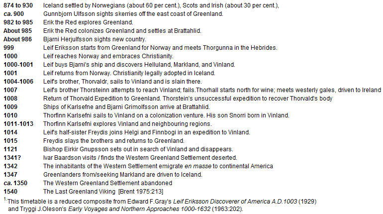
from 874-1540 CE in the table below,1 it may
be helpful to consider the standard chronology in the light
of information provided in a relatively
obscure source, namely The
History of Greenland by David Cranz published in 1767.
DAVID
CRANZ AND THE HISTORY OF
GREENLAND
Questions
concerning authenticity
aside, we may start here with the date of missionary David Cranz's
arrival
in Greenland in
1761 and later introduction to his
History of Greenland wherein he described this relatively
barren land as he
himself experienced it, i.e.,
Whoever
has seen the Norway coast, can form a pretty good idea of Greenland,
only with the difference, that here hills are not enriched with trees
nor valleys with grass, and also that the mountains do not run up high
and pointed only at a distance from the sea, but close by it.
However, here and there are long flat mountains to be seen, but these
are clad with perpetual snow. (David Cranz, The
History of Greenland Containing A Description of The Country and Its
Inhabitants, J. Dodsely, London
1767:4)
Not
exactly "Greenland" then, although this particular observation concerns
the
latter
part of the Little Ice Age in any case. Nevertheless, the
"perpetual snow" mentioned here is readily
recalled in the naming of Iceland
(Cranz,
1767:242)
According
to the
account of the learned Icelander Arngrim Jonas, Iceland was
accidentally discovered by a Norwegian called Naddoc (who intended to
go to the island Faeroes) and it was named Snowland... Flokki (later)
called it Iceland from the great quantity of ice.
Moreover,
given that snowfall pertains to the growth of the
Greenland icecap it would be both reasonable and accurate to call this
the salient feature, and thus suggest that Greenland was originally
"Snowland" with modern Iceland "Fireland" in keeping with the Greenland
Duality discussed in the previous section.
But
in any case, as
far as the eastside-westside problem is concerned, perhaps a better
understanding can be gained from the inclusion of the
eastern side
of Greenland in the historical descriptions provided by Cranz,
i.e.,
The name
Greenland was given to the east-side
of this land several hundred years
ago, by the Norway men and Icelanders, who first discovered it, and the
reason of the appellation or epithet Greenland was, because it looked
greener than Iceland. But the east-side, which is commonly called
Old or Lost Greenland,
is now almost
totally unknown because ships
cannot navigate this coast, on account of the great quantities of ice.
Some are of the opinion, that that Old Greenland so pompously described
by the Iceland authors as adorned with churches and villages, is now
lost and not to be found; and therefore are curious to know if we
cannot gather some account of it from the Greenlanders. But
the west-side may with the same propriety as the east-side, be called
the old lost Greenland (which is now found again, since ships have
sailed hither), for the old Norwegians have houses and churches there
too, plain traces of which are still to be found and the soil produces,
now at least, as much as the east-side, which was so famous and is so
much sought for. (David Cranz, History
of Greenland, 1770:2-3; emphases
supplied)
The
main point stressed here is that during
the time of the Medieval Warm
Period--especially the interval from 1050 through 1250
CE--conditions for maritime traffic between Iceland and Greenland
would
in all likelihood have been optimal,
at least
for certain parts of the year. Thus, unless later commentators were unaware
of the Medieval Warm Period
it is difficult to explain why
they considered that the eastern side of
Greenland was not only ice-blocked, but also largely uninhabited during
the earlier period. Nor do the additional distances required to round
the southernmost point of Greenland en
route to the western side follow the usual step-by-step
expansions expected after the initial sighting of the Gunnbiorn
Skerries on the eastern side. Again, unless, the Medieval Warm Period
was unknown to those with their own agendas and their own versions of
history.
At which point we may return to David Cranz and a
discussion
from the Annals of Old Greenland
that tells
the story of Erik the Red's three-year banishment from Iceland
and subsequent exploration of Greenland. Here, however, there are one
or two
notable
differences from modern accounts, especially with respect to both the
eastern side of
Greenland and accepted chronology, for according to Cranz,
Eric the Red:
§2 ...
coasted south-west, and
wintered in an
agreeable island near a sound, which he called “Eric’s Sound. The
next year he examined the mainland, and the third year went back to
Iceland. In order to entice people to go to his new country, he
called it Greenland, and painted it out as such an excellent place for
pastures, wood, and fish, that the next year he was followed thither by
25 ships full of colonists, who had furnished themselves richly with
household goods and cattle of all sorts; but only 14 of these ships
arrived. In
process of time more colonies came after, forth out
of Iceland and Norway and flooded the country
with inhabitants by
degrees both on the east and west-side, so that they were
computed to
be a third part as numerous as a Danish episcopal diocese.
§3 The
time of these events is recorded different. There are two
head-fountains of Greenland history: One is the Iceland Chronicles of
the very ancient Northern Historian Snorro Sturlesen, who was
nomophylax, or justitiary of the Ice-land Government about the year
1215.
His account is
preferred not only by the learned Arngrim
Jonas, adjutor of bishop Giernbrand Thorlak in Iceland in the beginning
of the last century, but also by the king’s historiographer Thormoder
Torfaeus, a native of Iceland, in his Groenlandie antigua, which I have
made the most use of.
These date the
discovery of Greenland in
the year 982. But on the other hand we have some Greenland Annals in
Danish verse, by a Divine, Claudius Christophersen, or Lyscander, who
suppose the discovery to be in the year 770. And this
calculation
seems not only to have some foundations in the antiquities of Iceland,
but is
corroborated by a Bull issued by Pope Gregory IV. A.N.
835,
wherein the conversion of the northern nations, and in
express
words the Iceland and Greenland diocese is committed to the first
northern apostle Ansgarius, who had been appointed Arch-bishop of
Hamburg by the Emperor Lewis the Pious. If the Bull is
authentic,
which we find no reason to doubt, Greenland must have been discovered
and planted 250 years earlier, about 832, by the Icelanders or
Norwegians.
§4
But
a greater
disagreement prevails in the discrepancy in counting, not
only between the records of Iceland and the Danes, but also between the
Icelanders themselves, neither could the Icelander Torfaeus reconcile
them after all his labours.
In his accounts, he follows chiefly the draughts of Ivar Beer who
was the Greenland bishop’s steward and justitiary, in the 14th
century. According
to the account Greenland was inhabited and
filled on both the east and west side. The east-side, which
is
now called old or lost Greenland,was divided into two
parts by a
promontory at the 63rd degree called Herjolf’s Nefs. (David
Cranz, The
History of Greenland Containing A Description of The Country and Its
Inhabitants. Translated from the
High Dutch J. Dodsely, London 1770:243-245; emphases supplied)
This
1760's chronicle is certainly at odds with
modern understanding of the matter, especially the date of
colonization. But how, and
not least of all when, did
these differences
occur? Well,
as explained by Joseph Fischer (1903:23-24) the modern
establishment of the Eastern Settlement on the west side
of Greenland
came to pass some twenty-five years after the publication Cranz's History of Greenland,
i.e., around 1792:
We may
endeavour to put together from these varied sources a picture of the
Norse colonies in Greenland, but then comes the question: “Where were
the old settlements ?” The solution at the first glance seems very
simple. The names Eystribygð (Eastern settlement), and
Vestribygð (Western settlement), seem to denote, without a shadow
of a doubt, that the colonies lay partly on the east and partly on the
west coasts of Greenland. In fact, before this it had been very
generally accepted that the eastern settlement was undoubtedly situated
on the east coast of Greenland, and some authorities have always
maintained this view, in most recent times Nordenskiöld;1
but the
majority of scholars now lean to the opinion that both colonies were
situated on the west coast of Greenland. Ruge, in his critical
review of the Periplus, only repeats the view of Nordenskiöld,
without mentioning the decided negative of Storm.3
It
may therefore be
not without interest to examine this instructive question of dispute in
somewhat exhaustive detail.
Early in the 16th century the Danes seriously took up the idea of
tracing the settlements in Greenland, but started with the firm
conviction that the eastern settlement must be on the east coast. This
opinion held the field, till, in 1792, Peter von Egger, in his prize
essay, Üeber
die Lage des grönlandischen. Ostdistriktes, proved from the
ancient sources of authority that “the old Eystribygð in Greenland
was not on the east coast, at that early period quite inaccessible, but
on the south-west coast.” Graah made researches (1828-31) which
confirmed Egger's conclusions, but without much permanent result, as
Major points out, because Graah had preconceived notions, and did
not examine the east coast of Greenland. Major was not satisfied with
Graah's argument, and went carefully through the old Norse authorities,
and particularly Ivar Bardsson. He finally came to the same conclusion
as Graah and Egger. Major is right when he considers the solution of
the riddle to lie in the correct location of the Cape Hvarf
(“Turning-point”). Ivar bases his theories on the eastern and western
districts on the following grounds: To the east of this there are only
uninhabited tracts, whose fjords are remarkable for the abundance of
fishes, while on the west of Hvarf there is a succession of places and
fjords, which are also set out in the Sagas, and belong to the eastern
district. Between the two districts there extends a desert territory 12
miles in length. At the most southern point of the western district
stood the great church of Steinesnes.3
Major weighed the evidence
carefully and came to the conclusion that Hvarf must have been a point
to the south of Greenland, and so the eastern district must have been
immediately to the west of southern Greenland. (Joseph Fischer, The
Discoveries of the Norsemen in America
with special relation to their early cartographical Representation.
Trans. Basil H. Soulsby, Burt Franklin, New York 1903:23-24)
3 Storm's
critique of
“Periplus,” p. 159. His
words are: “Nordenskiöld has already many years ago protested
against
‘the official chorography of Greenland,’ in assigning the eastern
settlement to the south-west coast of Greenland, but the basis of his
argument is weak and has never to my knowledge convinced any scholar.
The arguments used in his “Periplus” are not new, and have, I believe,
been altogether upset by the discoveries in the district of
Julianehaab, described in the Mitteilungen
über Grönland, part 16, 1896.”
S
o
there you have it; a "prize
essay" written in 1792 reinforced by
notable authorities plus a broadside at Nordenskiöld
who maintained otherwise. But as for
both Eastern and Western Settlements on modern Greenland, well, no one is
arguing that there were not likely to be Norse
settlements on the west side, or anything like that. What is suggested,
however,
is that the
present-day Eastern and Western settlements
of modern Greenland are NOT
necessarily the Eastern and Western Settlements of the Icelandic
Sagas anyway. This is one reason (one might
suggest) why so much difficulty with the
directions and
distances in the Sagas occurs, especially when the latter are
applied to the
Atlantic
side of North America. In fact, one could continue in this vein
and
suggest that this was "Iceland" and not
Greenland in any case. And even here the Icelandic "Book of
Settlements" is not so much an end of the matter as the opening up of
another potential can of worms. The Landnámabók was
itself written long
after the time allotted to the settlement process
and the Vinland voyages of "around a thousand years ago." In
fact,
information concerning the settlement phase is
based essentially on the
following later works (Pálsson
and Edwards 1972:5):
Ari's
Book of
Settlements (early twelfth century)
Styrmisbók
(c. 1220)
Melabók
(c. 1300-1310 )
Sturlubók
(c. 1275-80)
Hauksbók
(1306-08)
Skardsárbók
(before 1636)
Thórdarbók
(before 1670)
Because
of the lengthy interval involved even the stated reason for the
publication seems to have a dubious ring to it ( " Methinks they doth explain too much "
), i.e.,
In
theThórdarbók version of the Book of Settlements the
following apology is made for the study of the settlements and
genealogies:
People often say that writing about
the Settlements is irrelevant
learning, but we think we can better meet the criticism of foreigners
when they accuse us of being descended from slaves or scoundrels, if we
know for certain the truth about our ancestry. And for those who want
to know ancient lore and how to trace genealogies, it's better to start
at the beginning than to come in at the middle. Anyway, all civilized
nations want to know about the origins of their own society and the
beginnings of their own race.
This passage is obviously taken from a medieval source, apparently
Styrmisbók, and there is reason to believe that it may have been
taken from the original version of the Book of Settlements and so
reflect the early twelfth century attitudes of Ari Thorgilsson. What is
particularly interesting about this is the underlying suggestion that
the study of Iceland's beginnings was stimulated by foreign
misconceptions. It must have been well-known in Western Europe that
Iceland (insofar as it was known at all) was inhabited by
Scandinavians, who were frowned upon because of the viking raids. The
Book of Settlements shows us that there were relatively few vikings
among the settlers, most of whom were peaceable farmers, possibly in
some cases with good family connections in Scandinavia or the British
Isles. But these royal ancestries are not to be trusted, though it
would be difficult to say whether the genealogies were actually
invented by Ari and other learned men in the eleventh and twelfth
centuries. It should be noted, however, that some ancestors styled as
kings in Hauk Erlendsson's version are not so styled in the earlier
version of Sturla and probably not in Ari's or Styrmir's. (The Book of Settlements:
Landnámabók. translated by Herman Pálsson
and Paul Edwards, University
of Manitoba Press, Winnipeg 1972:7; italics supplied)
So where does this
leave us? It leaves us wondering to what extent the little-known
"Medieval Warm Period" and "Little Ice Age" may have contributed to the
currently accepted distribution after the 1792 "establishment" of both
Eastern and Western
Viking
settlements on the west coast of modern Greenland. More important,
however, remain the related issues, i.e.,
whether there were ever
Settlements of the east side, and why--for
whatever reasons and after at least 350 years of occupation--that the
Vikings are still
thought to have not only gone virtually nowhere else, but also to have
simply faded
away.
THE
"NOVA
GROENDLANDIAE" MAP
As for
the east-west settlement issue, just how convincing was the "prize
essay" of 1792, and if correct, then just how wrong was David Cranz?
And also, why
should such a disparity exist between the two histories? But most important of all, how can we explain the multiple locations and all the
details
on the eastern side of
Greenland shown on the
"NOVA
GROENDLANDIAE" map
accompanying
David Cranz's 1767 History of
Greenland ?
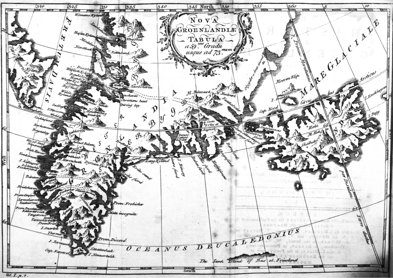
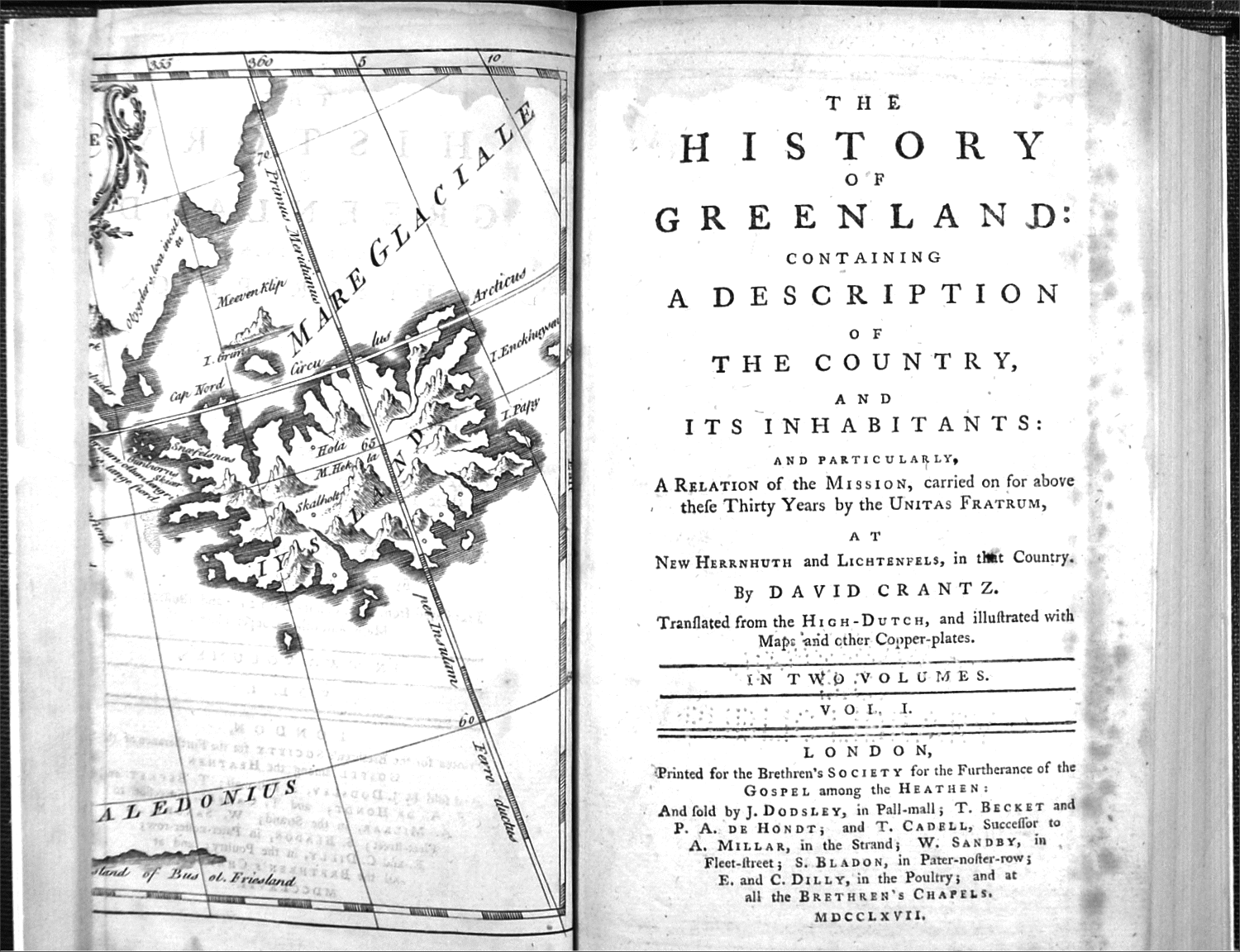
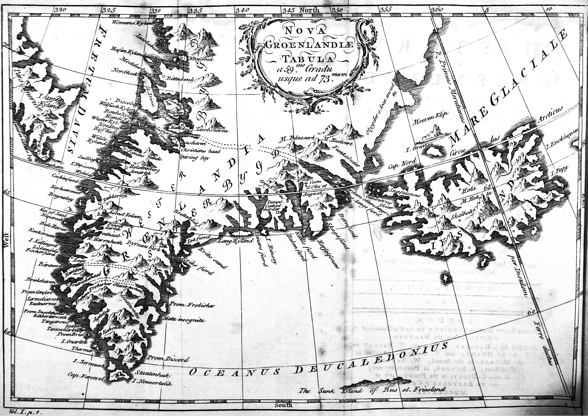
MAP
5a. THE NOVA
GROENLANDIAE MAP (Folded; Vol. I, p. 1.) accompanying
David Crantz's History
of Greenland. (1767?)
[ Larger (1500
x 1128 pixels, 485 kb) ]
MAP
5b. THE NOVA
GROENLANDIAE MAP Unfolded (Vol.I. p.1, David Cranz
1767? )
[ Larger
(2000
x 1415 pixels, 810 kb) ]
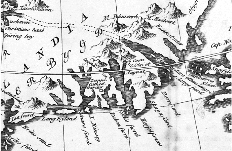
Map 5c below is a reduced segment of
the NOVA GROENLANDIAE map
that shows a
number of totally unexpected features, including a list of places on
the eastern side that includes
"Eric's Fiord," "Eric's
Sound," "Brattalhid," the
cathedral at "Gardar" and two additional churches--all apparently located on the eastern side of
Greenland.
MAP
5c. NOVA
GROENLANDAE II (
David Cranz 1767? )
A
further surprise shown above in another reduced segment (Map 5c) are
the
"Gunbioerns Skioer" between northwestern Iceland
and the southeast coast of Greenland. The latter have been dismissed outright by some or explained
away as mirages by others, although
according to John Fiske (1892:242)
the "sheers" simply no longer exist:
Midway
between
Iceland and Greenland there appears to have stood, in the Middle Ages,
a small volcanic island discovered by that Gunnbjörn who first
went to Greenland. It was known as Gunnbjörn's Skerries, and was
described by Ivar Bardsen. This island is no longer above the surface,
and its fate is recorded upon Ruysch's map of the world in the 1508
edition of Ptolemy: "Insula haec anno Domini 1456 fuit totaliter
combusta," – this island was entirely burnt (i.e. blown up in an
eruption) in 1456; and in later maps Mr. Major has found the corrupted
name "Gombar Scheer" applied to the dangerous reefs and shoals left
behind by this explosion.
(John Fiske. The Discovery of America,
Macmillan, London, 1892:241-42)
Nevertheless, they
do not appear to be shown submerged on
this map, and though the distance between Iceland and
Greenland is foreshortened, the "sheers" are generally where they were supposed to have
been.
Far more
interesting, however, are the three sets of
double-dashed lines
between the
east and west coasts of Greenland, with only the middle set remotely
explainable by
the two-part division at the 63rd degree of latitude mentioned earlier.
MAP
5d. NOVA
GROENLANDIAE III (
David Cranz 1767? )
But if so, why are there two
more sets
of double lines on this Map, the lowest around the
62nd parallel, and a
second between the 67th and 68th parallels terminating on the west coast around
Jacobshavn, and what might be their
purpose? Could all three be "overland" routes
across
the Greenland icecap? Not according to modern history and
Fridjof Nansen's forthright claim that
he was
the first to cross Greenland
in 1889, as the publication describing this feat the following year--The
First Crossing
of Greenland--subsequently
proclaimed. But was he really
the first to do so, and does not the archeological
evidence on the west side of Greenland establish that the "Eastern
Settlement" was indeed located on that side of Greenland in any case? Not
necessarily, at least according to David Cranz, who "explained" in the
first pages of his History that:
The
name greenland was given to the east-side of this land several
hundred years ago, by the Norway men and Icelanders, who first
discovered it, and the reason of the appellation or epithet Greenland
was, because it looked greener than Iceland. But the east-side,
which
is commonly called Old or Lost Greenland, is now almost totally unknown
because ships cannot navigate this coast, on account of the great
quantities of ice.
Some are of the opinion, that Old Greenland so
pompously described
by the Iceland authors as adorned with churches and villages, is now
lost and not to be found; and therefore are curious to know if we
cannot gather some account of it from the Greenlanders. But the
west-side may with the same propriety as the east-side, be called the
old lost Greenland (which is now found again, since ships have sailed
hither), for the old Norwegians have houses and churches there too,
plain traces of which are still to be found and the soil produces, now
at least, as much as the east-side, which was so famous and is so much
sought for. (David Cranz, 1767:2–3)
Thus an account that not only
includes
the east side of Greenland, but also the
effects on
maritime
transportation of
the unrecognized Little Ice Age.
A
MUTUALLY BENEFICIAL COOPERATIVE VENTURE
More significantly, consider the strategic
positions of the western locations of the
three
sets of dotted lines displayed on the NOVA GROENLANDIAE MAP.
But first
and foremost, what
is one to make of this map?
All that will be said at the moment is that
this large and incredibly
detailed map was the folded first page of a 1903 edition
of the History of Greenland (1767)
obtained
from a public library and not (perhaps significantly) an academic
institutiion. As for
questions
concerning its authenticity (or otherwise), these will be deferred
until later for reasons that willl become increasingly apparent as we
proceed.
Secondly, where (and
how) might "Thule" as a geographical extremity fit into all of this?, i.e.
the Ultima Thule of ancient
history as opposed to the like naming of
the whale-hunting Alaskan Inuit, who "about a thousand years ago" swept rapidly across the
top of North America as far as Greenland and ultimately (it is
claimed) replaced
the Dorset.
Did this
not take
place then? According to the
archeaological record it seems that it did, but even so problems
remain--not so much the rapid west-to-east migration of the
Thule per
se--but
why in the easternmost location the newcomers travelled so far north to "Thule" itself on
the upper
northwest
coast of Greenland, almost
ten
degrees above the Arctic
Circle. And also a place where Peter Freuchen, who visited the region
with Knud Rasmussen (1935:45) cautions us to "remember that the
Thule District–as it was named because it is the
northernmost in the world–is not teeming with game.” So what other reasons
could there have
been to swing so far north to such basically inhospitable latitudes,
not only in
western Greenland but also above the 79th parallel to Bache
and Knud Peninsulas on the east
coast of Canada's Ellesmere Island, as Peter Schlederman's research
from 1975
through 1996 established? Although partly
explained in terms of
obtaining northern trade goods and foodstuffs etc., was it really
necessary to travel that far north
and then west
for items undoubtedly available further south?
Or were there other reasons for their presence there in
addition to carrying out these relatively mundane activities?
Enter now the
Vikings and
continued Viking transits across the top of North America in the years
that followed the early
voyages
of discovery recounted in the Sagas. Although subsequent activities would depend in no
small way on what the
Vikings wished to accomplish overall, it can be suggested that
instead of expending their own ships, manpower and time on
subsistence needs and/or intermediate transportation within the Arctic
regions, that as part of the
greater scheme of things the Vikings most
sensibly sought local
specialists to
assist with routine but necessary tasks, starting with Greenland
itself. And if assistance was initially unavailable there--either in
sufficient numbers or for lack of requisite skills in
the Eastern and Central Arctic (the Dorset?)--then
it may have been worthwhile to
encourage an influx of "foreign
specialists" to fill
the void. Needless to say, indigenous peoples from elsewhere in the
North skilled in hunting whales and marine mammals, with their own
shallow-draft, small and high capacity
boats (Kayaks and Umiaks) familiar with the rigours of the North
would
have been
virtually ideal, initial
linguistic differences notwithstanding.
Enter next
then, whale-hunting Inuit from Alaska--shortly thereafter the Thule
(perhaps)--who
would readily meet all such requirements. Thus for the most part(?)
invited specialists, who
arrived--not so much out of desperate need or as invaders--but as willing
participants in a
mutually
beneficial cooperative arrangement over and above quests
for
more plentiful hunting grounds or possible conflicts within their
own
traditional
Alaskan territories. To which may also be added continued assistance
rendered on both sides of Greenland,
specially in the regions of the east coast arrival points and the
ice-cap routes, and not necessarily limited to this alone. There would
also be the linguistic side of the matter, as well as transportation
and sustenance, both across the Ice-cap and in the regions far to the
west beyond Greenland.
Thus perhaps (in part at least), a
suggested
cooperative venture between the Norse and Alaskan Inuit (subsequently
the "Thule") that may indeed have commenced "about a thousand years
ago"
following
initial Viking explorations to the West, and continued on until either
the
Little Ice Age closed the western routes, or all unauthorized movements
aided by the ex-Greenland Vikings finally ceased completely following
their
own ultimate departure.
As
for the degree of assistance rendered and rewards
received, in some respects new and more plentiful hunting grounds might
have been more than
enough for ex-Alaskan Thule, especially if augmented by
additional "payments" for specific
tasks and duties rendered. One can only theorize about such
possibilities, but it is perhaps telling that when a Canadian
government expedition led by J. W. Tyrrell
in 1893 encountered Inuit far inland along the
Thelon/Akilinik river system the latter not only provided them with "a
sketch map of our course thence to the 'sea' or Hudson Bay" (Tyrrell
1893:119), but also, in their swift and maneuverable kayaks these same
Inuit, though unasked also appointed themselves guides and
helpers: "We were pleased to
learn from the natives that there were no more rapids or
obstructions to be encountered. As we proceeded, however, we found the
current both strong and swift, and quite rough in some places, but the
Eskimos in their kyacks shot ahead from time to time and showed us the
best channels."(ibid). This
kind of assistance would have had
the
same or greater value further
north, especially among the more tortuous segments through the
Arctic Archipelago, and indeed just about anywhere along the Arctic
coast.
Even so, this is
merely one possibility. Other valuable services might have included
habitation, procurement, distribution, preparation and dissemination of
foodstuffs--here not least of all seal oil for winter heating, etc..
And also,
perhaps,
intermediate transportation duties utilizing smaller Viking ships
and/or Umiaks, with partly Inuit crews familiar with the way, or even
fully so in the case of the latter vessels. All of which, of course,
would require considerable planning and efficient organization, though
not necessarily on a year-round basis, but over peak and
optimum periods for travel, etc. But in any case,
given the lengthy interval involved--a minimum of three and a half
centuries--there
would have been
time enough to consolidate both the means and methodology required.
As for records and remnants of a transient Norse presence at "Thule"
sites along the way, this would difficult to detect, apart from the few
indications already found that are largely downplayed by an insistence
that all rectangular stone structures in the Arctic
are of purely
Inuit origin.
But in any event, towards the end, with visits to
Greenland restricted
to Norwegian ships and as the Medieval Warm Period began to subside,
the
Little
Ice Again also set in around Greenland and across the
Northwest
Passage. Thus there would have been increasingly less contact with the
Inuit, and if
the disputed migration had also come to a satisfactory conclusion,
little or no further
need for assistance. Therefore it would not be surprising if only
a residual memory remained among the Greenland Inuit, that others stayed where they
were either by choice or circumstance, and that in some instances
back-migration to Alaska may also have
taken place, as indeed discussed in an alternative norse-related
context by
James Robert Enterline (2002:142).
PORTS AND POINTS OF DEPARTURE
In light of the above,
the Nova Groenlandiae Map assignments, and the
Pacific Northwest Hypothesis, a scenario that differs markedly
from prevailing views concerning what occurred in the Eastern
Arctic "about a thousand years ago" may now be proposed.
Namely, that
the considerable longitudinal extent of the Thule migration and the
activities at
high
latitudes in the east may be explained by a mutually beneficial
arrangement
between the Norse and the Thule that encompassed the beginning, the
maximum, and ultimately the end of the Medieval Warm Period. Thus in due order and also from north to south to north,
Western, Middle and Eastern "settlements" on the west coast of
Greenland may now be
considered in functional terms to be Viking arrival and
departure
ports as shown on Map
5e below:
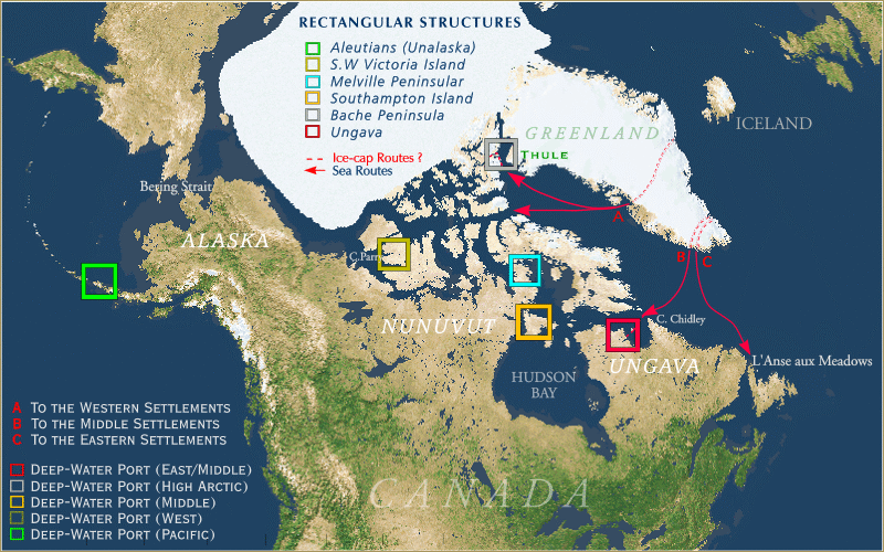
MAP
5e. Major Viking
Ports for the Eastern, Middle and Western Settlements
of North America
Even so, "ports" A, B
and C may
not correlate
with established
archaelogical settlements on the west side of Greenland
today. Nor indeed should the former necessarily replace the latter
entirely, for things may not be quite that straightforward anyway, i.e.,yet again another set
of dualities intended to preserve and protect the many-sided truths
of this
matter.
But in any rate,
a cooperative venture during the time when optimal
conditions for successful transits of
the Northwest Passage likely existed and a high latitude route via
Bache
Peninsula and Sverdrup Pass may have represented a swifter and more
practical
alternative to those at lower latitudes. Or in addition, perhaps, since
the scenario presented here includes
the possibility of large-scale movements as well as on-going visits to
the Pacific Northwest and voyages of
discovery further afield.
A
LENGTHY, DANGEROUS AND UNCERTAIN VENTURE
We come now to
a matter that rarely seems to be considered in discussions concerning
"The Northwest Passage," namely the distance that remains after passing
through the
Arctic Archipelago.The latter is recognized today to be merely the first part of the Canadian segment
of the Northwest
Passage, either via the lower latitudes from Cape Chidley and the
Labrador Sea in the East to Cape Parry
and the Beaufort Sea in the West, or via the upper latitudes from
Baffin Bay in the East to the Beaufort Sea in the West via Lancaster
Sound, etc. Either way, neither
represent the Northwest Passage in
toto, but more to the point, even after completing this first
segment further lengthy journeys
remain in our present Pacific Northwest context. Firstly, westward
along the North Slope of Alaska, then south to Bering
Strait (more than 1200 miles) followed in turn by another 800 miles or
so to the first practical gap in the Aleutians, a grand total of more
than 2,000 miles before sailing eastward to the
Pacific Northwest. Not only this,
but immediately after passing through the Arctic Archipelago the
coastal route swings north again before rounding Point Barrow above
71 degrees just as winter is fast approaching. Or is
it? Or better stated, in light of the considerable distances
involved,
irrespective of the Medieval Warm Period and optimal conditions,
attempting such lengthy transits in one season would, more likely than
not, always be a
lengthy, dangerous and uncertain venture.
THE
ALTERNATIVE, IF NOT THE NORM
Which is not to say
that the Passage
could not have been accomplished more easily and more swiftly, but
merely
to suggest that other options might
nonetheless have been required. Moreover, remaining
with the grander scheme of things, completing the northern section of
the Northwest Passage would, above else, depend on speed and
efficiency, even for single ships and small expeditions. Larger groups
would have additional requirements, and likely more problems if they
were to
remain together, with all expeditions requirng meticulous planning and
organization beyond that already gained
by mounting
long-range Viking raids, etc. Over time, however, additional holding
and transfer
points could become established and maximised to allow for
wintering-over
should this become necessary, or even at times standard practice. Here
at least
we already have locations critically
posiitoned across the Canadian North, but this said,
further refinements may still be added. The need for speed
through the Northwest Passage itself could have been handled by larger Viking
ships over the longer, open-water hauls with the shorter, more
circuitous routes delegated to smaller Viking ships and/or Umiaks, with
or
without the predominant use of sails. The
latter would no doubt
be advantageous at times, but rowing continuously
during the long daylight hours available at high latitudes would
largely circumvent delays caused by
unfavourable winds and
adverse weather. In short, the lighter, shallow-draft Viking
ships and/or
Umiaks could continue across the North in all but the foulest
weather,
with the latter the most flexible of all. Such vessels might still be
damaged from time to time, but rarely (if ever) locked in the winter
ice and crushed like so many large sailing ships that later met
this almost inevitable end.
Even so, failure to
clear the Northern
regions
before winter finally set in would result in severe consequences,
though less
so if this was anticipated and steps were taken to minimise the
difficulties. Nevertheless, such delays would still consume time and
multiple resources throughout the long, dark and cold winters of the
North. But it may still have been unavoidable, and at least from time
to time it may have become a practical alternative, if not the norm.
And not a secret either, just a possible and natural consequence of the
many difficultites inherent in the journey.
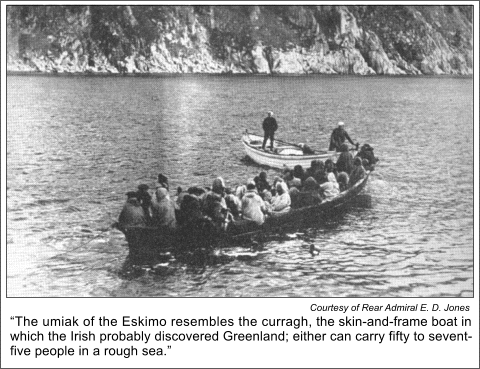
A TRIP BY GREENLAND UMIAK
As for
the
capabilities of Umiaks, the experiences of Peter Freuchen, who to took
a short trip by Umiak to procure sled dogs for the
Mylius-Erichsen.Expedition to Map North-eastern Greenland serves to
emphasize both
the capabilities of this kind of vessel and also the value (if not the
necessity) of shared duties in the Arctic. Umiaks were considered to be
"Women's Boats" and as such generally crewed by them. Except, it seems,
when passengers such as young Peter Freuchen--fresh off the boat from
Denmark--gallantly offered to lend a hand:
We went by
“women's boats" because the oarsmen are all women. It
would have been a disgrace for a man to ride in a skin boat except as a
passenger or a steersman... On my way to buy the dogs I sat in the
stern of the skin boat watching the tactics of the kayakmen with utter
fascination. But I was not accustomed to sitting idle while women
worked, so I insisted upon taking an oar, to the great amusement of
both the men and the girls. A few hours of the pace set by the women
left me gasping, and it took no great amount of persuasion to make me
relinquish my oar to the embarrassed young woman who had been trying to
coach me.
The stamina and strength of these girls is astonishing. They sing
through the whole day's rowing. Their songs are usually improvisations
to fit the occasion, sung to some familiar Danish tune. They laugh and
joke and tell stories as they row, often kidding the passenger who does
not understand what they are saying.
Many of those in my boat were elderly women...
The trip took us thirteen hours and I thought surely the girls
would be completely exhausted. Yet when they were told that there was
to be a dance that night in the post manager's workhouse, they whooped
with joy. After a day's rowing, a night of dancing would be just the
needed relaxation! (Peter Freuchen, ARCTIC
ADVENTURE: My Life in the
Frozen North. Farrar & Rinehart, New York 1935:10, AMS
Reprint
1976).
A CANADIAN UMIAK IN HUDSON STRAIT
A few years
earlier (1903-1904) the report of a Canadian govenment expedition to
Hudson Bay and the Arctic Islands by the D.G.S. Neptune included a photograph of a
sizable umiak in Canadian waters at Wakeham Bay. It is included here
because it well illustrates the dimensions and capabilty of such
vessels,
though not everyone would agree entirely with its accompanying caption.
Fig.
5f.
"Woman's Boat" at Wakeham Bay, Hudson
Strait. Early 1900s
Albert P. Low, THE
CRUISE OF THE NEPTUNE:(1903-1904)..
Nevertheless,
although it will not be discussed here and now a considerable Irish
component to this matter undoubtedly exists.
A LONG,
DIFFICULT AND UNPLEASANT JOURNEY
But in any case,
with
wintering-over included, it would require two years to reach the Pacific
Northwest, and a futher two
years for the return journey. Allowing a minimum of
one year to transact business, etc., it would therefore at best take
five years to
complete a round trip from Europe. Thus a long,
difficult and unpleasant journey at the best of times, but a worthwhile
one-way voyage for
those hoping for a new life in "Greenland" and "Vinland," albeit,
perhaps, without permissions or blessings from the European powers
that be. But suppose that these same
powers not ony laid claim to the new territories, but also demanded
obediance, and not least of all, tithes and tributes from those who had
settled there?
Did
this ever happen? Possibly, or at least the dire
prospects of such a
round trip seem to have been given serious consideration, with the
former
perhaps even the
subject of an actual complaint.
Witness,
for example, the following footnote explaining the selection
of certain “Papal Letters Concerning the Bishopric of
Gardar in
Greenland during the Fifteenth Century"--Letter II in particular:
1. In
1893 an American in Rome, Mr. J. C. Heywood . . . brought out, in a
very small edition (twenty-five copies) a book of photographic
facsimiles of documents in the Vatican relating to Greenland and the
discovery of America, Documenta
Selecta e Tabulario Secrete Vaticano. The Latin text of those
here presented may be found in Fischer, Discoveries of the Northmen, pp.
49-51. A translation made for the
Tennessee Historical Society by Rev. John B. Morris and printed
in Vol. IX. of the society's organ, the American Historical Magazine. Using
this translation, we have printed Letters IX. and X. as the only ones
that contain anything of particular interest concerning the Gardar
bishopric in Greenland, excepting, possibly, the following sentence
from Letter II (December
4, 1276), to the Archbishop of Drontheim: ‘Your Fraternity having been
explicitly directed by letters apostolic to visiting personally all
parts of the kingdom of Norway, for the purpose of collecting the
tithes due the Holy Land, has informed us that this seems almost
impossible, when
it is taken into consideration that the diocese in
Greenland is so remote from your metropolitan see and kingdom that five
years or more would be consumed in going thither and returning.’
It has
been inferred, on account of the length of this time, that the Vinland
colony was included. There is no documentary evidence of this.
The
papal letters contain no reference to Vinland. (The Northmen, Columbus and Cabot,
985-1503. Ed. Julius E. Olsen, C. Scribner’s
sons, New York, 1906, Barnes &
Noble reprint, New York, 1967:70-71.Emphases supplied)
As
far as tithe-collecting in Europe may be concerned, would (or should) it
require two years
in each direction plus another just to collect tributes from modern
Greenland? This would seem unlikely,
but it would be almost a certainty if both "Greenland" and "Vinland"
lay
on the far side of the World and the far side of North America in
addition. To which may also be added that although using more modern
ships, it took David Cranz only 76 days to reach the west coast of
Greenland from Denmark (Copenhagen) in 1761, and departing at a later
time in the year 98 days for the return leg, thus less than six months
travel by sea for the entire trip.
But in any case, the major
point of interest here is not so much the references to
"Vinland" at the end, negative though they are, but very the fact
that Vinland is mentioned at all, which indicates--rather than
suggests--that Vinland
did indeed exist, and
moreover, that Vinland must almost
certainly have been located a
considerable distance from Scandinavia and Europe since the
essence
of the complaint was
that: “five
years or
more would be consumed in going thither and returning.” The
latter
interval has already been "explained" above in terms of wintering-over
in the
Northwest Passage in both directions,
which in our present context
would indeed include a round trip to and from "Vinland" in the Pacific
Northwest. Lastly, with space always at a premium, transporting
tithe-collectors and the like over such distances
would have been an unwanted imposition and an unproductive
burden.
As such one cannot discount the possibility that the
difficulties en route may
have been amplified rather than diminished, including, perhaps,
even deliberate wintering-over, intended, as the French would say, "to
encourage
the others." Moreover,
even if collectors and administrators, etc., did manage to arrive in the
Pacific Northwest,
apart from being unwelcome they may also have been fundamentally
unsuccessful in
pursuing their duties. At which point their only hope would be
permission to remain there in perpetuity as opposed to a swift and
hostile conclusion to
the matter.
In any event, although feasible
(as opposed to being impossible), wintering-over in
the
Arctic regions would always be an undesirable option, but as the
Medieval
Warm Period began to wind down it might well have
become more a fact of life as one-season transits through the Northwest
Passage came to a close. Or because of this, a secondary form of
movement was adopted simultaneously out of necessity, or
according to a plan that increasingly involved the interior of North
America as opposed to northern coastal cruising. Thus by extension, the
summer
use of
rivers augmented by overland routes in both summer and winter. It is at
this juncture that one begins to realise (or at least suspect) that
this whole matter has a number of complex aspects, not least of all the
possibility of large-scale movements
into
Hudson Bay for
points south and southwest into and across North America. These aspects
will be examined in detail in the next section.
THE
GROENLANDIAE MAP--TRUE OR FALSE?
So, The NOVA GROENLANDIAE MAP:
1. Is it completely
genuine?
2. Is it entirely fraudulent?
3. Is it something in between?
Here I must admit to reading the History of
Greenland by
David
Cranz belatedly,
largely because of highly negative and dismissive prevailing attitudes
towards
the latter's work. In retrospect I should have known better--as
should
others, I would hazard--but that is another matter for another time.
Frankly I am still puzzled by
the details, and not least of all--true or false--by the limited
treatment
of this fascinating map in present-day literature. However, some things
seem clear
enough, including the location of the Prime Meridian (zero degrees longitude) assigned to Greenwich in
1881. In the present map, however, the Prime Meridian passes some eighteen degrees
futher west
through Iceland (and by extension southwards through the Canary
Islands) thus it is undoubtedly an earlier assignment. Although this does
not in itself prove the map is genuine,
it is nevertheless closer to the publication date of the History of
Greenland
in 1767. Always assuming,
of course, that the map was indeed an integral part of the initial
publication and not a later addition. In any event, I will this leave
matter and like elements to experts, noting only that both the map
and the double-dashed lines across Greenland undoubtedly provide room
for thought in addition to sufficient details that just might be in
keeping with a lengthy Norse presence in this land that extended for at
least three and a half centuries.
This said, and whatever
the outcome, the production and publication of a
highly detailed,
full-page, fold-out map not only indicates a
considerable amount of scholarly effort, it also represents a sizable
expenditure
of both time and--not least of all--money. None of which necessarily
establishes that the map is genuine, of course. Nevertheless, these
aspects tend to make the
"additions" to the so-called "Vinland Map" appear almost purile by
comparison. Not that there is any wish to resurrect the latter here
given that it has
been
duly and sufficiently discredited by now, especially by Kirsten
Seaver (1995-2001), the detailed
review of the parent publication and map by Lars
Lönnroth (1997:115-20) and the rejection of the Vinland map on nautical
grounds by G. J. Marcus (1981:xii). As the latter
pointed out:
In
most general histories the maritime aspect of affairs is by far the
most neglected side of the matter. The truth is that the academic
authority shies away from the difficulties and dangers of a whole range
of problems that demand highly specialized knowledge to which as a rule
he does not attain. The protracted and for the most part pointless
controversy that arose some years ago concerning the authenticity of
the ‘Vinland Map’ was a notable example of academic ignorance of the
‘sea affair’. But for this ignorance, the pretensions of the ‘Vinland
Map’ would surely have been rejected out of hand. As it was, a great
deal of time and energy was expended to little or no effect.
The fundamental weakness of the academic approach in
this field is that the savant, however erudite, is for the most part
totally lacking in practical experience and understanding (G. J. Marcus, The Conquest of the North Atlantic,
Oxford University Press, New York 1981:xii).
This I
include as a caution for those who may wish to dismiss the NOVA GROENLANDIAE MAP outright on
one hand, or embrace it uncritically on the other. It may, I suspect, be more
option #3 than either of the two polar opposites (no pun intended). But
either way it
also brings with it further complexities concerning not only the date
and place of origin but also the
fundamental purpose behind its original inclusion.
As
for the "authenticity" of the NOVA
GROENLANDIAE MAP this may depend in part on the following
section. Suffice it to say at this juncture, however, that like it or
not, it at least sheds additional light on what is becoming an
increasingly complex matter in both temporal and geographical terms.
BIBLIOGRAPHY
Brent,
Peter.THE
VIKING SAGA, Tinling, Prescott, 1975.
Cranz,
David. The History of
Greenland Containing A Description of The Country and Its Inhabitants.
Translated from the High Dutch J. Dodsely, London 1767.
Enterline, James Robert. Erikson, Eskimos,
and Columbus, The Johns Hopkins University Press, Baltimore,
2002.
Farley, Gloria. In
Plain Sight. ISAC Press, Columbus, 1984.
Fischer, Joseph. The Discoveries of
the Norsemen in America with special relation to their early
cartographical Representation. Trans. Basil H. Soulsby, Burt
Franklin, New York 1903. (Reprinted in 1970).
Freuchen, Peter. ARCTIC ADVENTURE: My Life in the Frozen
North. Farrar & Rinehart, New York 1935.
Fischer, Joseph.
The
Discoveries of the Norsemen in America
with special relation to their early cartographical Representation.
Trans. Basil H. Soulsby, Burt Franklin, New York 1903.
Fiske, John. The Discovery of
America with some Account of Ancient
America and the Spanish Conquest, 2 Vols., Macmillan and Co.,
London
1892.
Gathorne-Hardy, G. M. The Norse
Discoverers of America: The Wineland
Sagas. translated and discussed by G.M. Gathorne-Hardy with a
new
Preface by the Author and a new Introduction by Gwyn Jones. Clarendon
Press, Oxford 1970:55–56. [Original version published in 1921]
Ingstad,
Helge.WESTWARD TO
VINLAND: The Discovery of Pre-Columbian
Norse House-sites in North America (trans from Norwegian by Erik
J. Friis), Macmillan of Canada, Toronto, 1969.
Jóhannessen, Jón. Íslendinga Saga: A History of the
Old Icelandic Commonwealth. Trans. Harald Bessason, University
of Manitoba Press, Winnipeg 1974.
Lönnroth, Lars. Review of The Vinland Map and the
“Tartar
Relation” by Raleigh A. Skelton, Thomas E. Marston, and George D.
Painter (New Haven, Yale Univ. Press, 1995) in
alvíssmál 7
(1997:115–20).
Low,
Albert P. THE
CRUISE OF THE NEPTUNE: Report on the Dominion Government
Expedition to
Hudson Bay and the Arctic Islands on Board the D.G.S. Neptune 1903-1904,
Government Printing Bureau, Ottawa, 1906.
Marcus, G. J. The
Conquest of the North Atlantic, Oxford University Press, New
York 1981.
Nansen,
Fridtjof. In Northern Mists,
2 Vols. Frederick A Stokes, New York, 1911.
_____________ Farthest
North, Harper & Brothers, New York & London. 1897.
_____________ The First Crossing
of
Greenland, Longmans, Green & Co., New York, 1890.
Oleson,
Tryggi J. Early
Voyages and Northern Approaches 1000 - 1632. McClelland &
Stewart, Toronto 1963.
Olsen,
Julius E. The Northmen, Columbus and
Cabot,
985-1503:The Voyages of the Northmen. Ed. Julius E.
Olsen. C. Scribner’s sons, New York, 1906. Barnes
and
Noble reprint, New York, 1967.
Pálsson,
Herman and Paul Edwards. Trans.The
Book of Settlements:
Landnámabók. University of Manitoba Press,
Winnipeg, 1972.
Rasmussen, Knud. ACROSS ARCTIC
AMERICA: Narrative of the Fifth Thule Expedition, Greenwood
Press, New York, 1969 (originally published in 1927 by G.P. Putnam’s
Sons.)
Reeves,
Arthur. M. The
Finding
of Wineland the Good: The History of the Icelandic Discovery of America,
Burt Franklin, New York, 1895.
_____________, North
Ludlow Beamish, and Rasmus B. Anderson, The Norse
Discovery of America, The Norrenoena Society, London,
Stockholm, Copenhagen, Berlin, New York,1906.
Schlederman
Peter.
VOICES IN STONE: A Personal Journey
into the Arctic Past, Komatik Series No.5, Arctic Institute of
North
America, Calgary, 1996.
_____________ Crossroads
to Greenland: 3000 years of prehistory in the Eastern High Arctic.
Calgary Arctic Institute
of North America, K.series No.2, 1990.
_____________
"Eskimo and
Viking
Finds in the High Arctic," National
Geographic Magazine, Vol. 159, No. 5, May 1981.
_____________
Thule Eskimo prehistory of Cumberland Sound, Baffin Island,
Canada, National Museum of Canada, Ottawa, 1975.
Seaver,
Kirsten. Maps, Myths, and Mern.
Stanford University
Press, Stanford, 2004.
_____________
"Renewing the
Quest for Vinland: The Stefansson, Resen and Thorlaksson Maps." Mercator's
World, No. 5
Vol 5. Sept/Oct 2000.
_____________
"Good Bye Columbus
I,"
Letters to
the Editor, Mercator's
World, No. 5
Vol 5. Sept/Oct 2000.
_____________
"The Vinland Map". Mercator's World,
No. 2 Vol 2. Mar/Apr. 1997.
_____________
The
Frozen Echo, Stanford University Press,
Stanford, 1996.
_____________ 'The Vinland Map' Who
Made it and Why. New Light on an Old Controversy" The Map
Collector,
No. 70, Spring 1995.
Stefannson, John."The Land
of Fire, National Geographic Magazine,
Vol. XVIII, No 11, November 1907.
Tyrrell,
J. W. Report
of J. W. Tyrrell,
D.L.S. Exploratory Survey Between Great Slave Lake and Hudson Bay,
Districts of Mackenzie and Keewatin. Govt.
Printing Bureau,
Ottawa, 1902.
THE
LAST VIKING
Introduction to The
Last Viking
Part 1. Viking
Press and
Viking
Ships
Part 2. West by Northwest
Part 3. Three Steps Back
Part 4.
The Nova
Groenlandiae Map [Current Selection]
Part 5. The Mysterious
Akilinik of the Greenlanders
Part 6. Symbols, Markers and
Indicators
Part 7. Reflections
in the
King's Mirror
Part 8. South by Southeast
Part 9. The
Copper
Canoe
Part 10. The Warp and the Weave
Part 11. Helluland, Markland
and
Vinland
Part 12. The Golden
Apples of the Sun
Maps: Partial Map Listing
for the Last Viking
Postscript 1: A Fir Tree of the
Mind
(pdf)
Postscript 2: RongoRongo and the
Raven's Tail
OTHER: Easter Island
Stone Structures
Copyright ©
1999.
John N.
Harris, M.A.(CMNS). Last Updated on December 22, 2023.
Return
to spirasolaris.ca


