
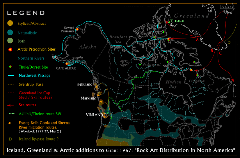
1. The Akilinik would not have remained so long "mysterious" (known only, so far as the writer is aware, through Greenlandic folk-lore) if travellers in northern Canada had taken the trouble to make geographic inquiries and to record the native names of conspicuous natural features. It is one of the large rivers of Canada and one of the chief loci of commercial activity and cultural development of Arctic America. (Vilhjalmur Stefansson. "Prehistoric and Present Commerce among the Arctic Coast Eskimo." Geological Survey of Canada, Museum Bulletin No.6, Ottawa, 1914:21)
Unfortunately, the exact point of departure for the overland segment of the above is unknown and it may well be coincidence that the direction taken thereafter generally matches the newly suggested routes--the Akilinik/Thelon included. Then again, as taken up in Part VIII, the Norse adventurers still end up (it is suggested) in Helluland in the Pacific Northwest when the next part of Bard's Saga is examined in more detail. Moreover, both the overall concept and application here are certainly helpful, as are the references to Hellulland and Greenland, with the latter that of the Greenland duality, i.e., North America itself, and accordingly, with Helluland (as before) likewise located in the Pacific Northwest.. . . came to the wastes of Greenland. The winter was approaching by then, so they stayed through the winter.
They went away from there in the spring, each bearing his own provisions.
First they went overland in a south-westerly direction; then they turned across the land. They came to glaciers first ... (rest omitted).
(Sarah M Anderson, trans. Bard's Saga, in Hreinsson, Vidar. Ed. The Complete Sagas of Icelanders Including 49 Tales. Leifur Eiriksson Publishing, Reykjavik, 1997:262; emphases supplied; added for completeness (ibid), in the end "they all went back the same way.")
Beginning at Black Lake, you make a long portage northward to a little lake, then across five or six more small ones and a corresponding number of portages, and a large body of water called Wolverine Lake will be reached. Pass through this, and ascend a river flowing into it from the northward, until Active Man Lake is reached. This lake will take two days to cross, and at its northern extremity the Height of Land will be reached. Over this make a portage until another large lake of about equal size is entered. From the north end of this second large lake, a great river flows to the northward through a treeless country unknown to the Indians, but inhabited by savage Eskimos. Where the river empties into the sea we cannot tell, but it flows a great way to the northward. (J. W. Tyrrell. ACROSS THE SUB-ARCTIC OF CANADA, A Journey of 3,200 miles by Canoe and Snow-Shoe Through the Barren Lands, Coles Publishing, Toronto, 1973:8) [originally published in 1898]
The river in question did indeed turn out to be the Thelon, although along the way it was referred to as the "Telzoa" (broad shallow river; Tyrrell, 1898:82). More to the point, however, the survey necessarily included the place where the Akilinik/Thelon flows into Baker Lake, which was described in terms of the river's potential value for inland transportation as follows:
At the mouth of the river the water was found to be shallow–in some places not more than three or four feet in depth–and for some distance out into the lake shoals were observed. Small sailing vessels or York boats would, however, have no difficulty in getting in, but it would be difficult to take the former any great distance up the river on account of the rapids. Large properly constructed river boats might be taken up stream without difficulty for a distance of 150 miles to the confluence of the west branch, and how far they might be able to ascend that large stream it is impossible for me to say. With the exception of perhaps one spot–the canyon rapid north of Tobawnt Lake–I believe the whole river from the Height of Land to Baker Lake might be navigated by river or York boats with comparative ease. At the rapid a portage could be made or possibly a navigable channel might be discovered. (J. W. Tyrrell. ACROSS THE SUB-ARCTIC OF CANADA, A Journey of 3,200 miles by Canoe and Snow-Shoe Through the Barren Lands, Coles Publishing, Toronto, 1973:173) [originally published in 1898]
THE
THELON RIVER--ONE OF THE FINEST IN CANADA
However,
it required a further government survey of the region between Great
Slave Lake and Hudson Bay in 1900
(again by J. W. Tyrrell)
to fully appreciate the
Aklilinik/Thelon route. Some idea of its suitability
for inroads into North America can be gained from the expedition's
final report:
1st. The obtaining of a correct topographical map of the routes traversed, in connection with which may be mentioned the discovery of the Thelon river–one of the finest in Canada–navigable for river steamers or other boats of light draught all the way from Hudson bay to the forks of the Hanbury, a distance of 550 miles; excepting perhaps at two rapids on the river above Baker lake, where some improvement to the channels might be made. Just what length of time this route may be open for navigation I am unable to say precisely, but would judge that the river portion must be open at least five months, and the inlet and larger lakes about a month less, i.e., during the months of July, August, September and October.
Thus the possibilities and extent of navigation from Hudson bay towards the west, by way of Chesterfield inlet, have been pretty well determined.
In the Mackenzie basin, Charlton harbour, at the head of Great Slave lake, limits navigation from the west, and on its northern shore by the mouth of the Lockhart river is as pretty a town site as can be found in Canada. Between these two terminal points the only existing way of communication is by means of the excellent canoe route followed by my party ...
... Beside the discovery of the Thelon as a commercial waterway the resources of its valley should be of great interest, particularly its timber and herds of musk oxen, both of which are of great value to Canada.
For the preservation of the musk ox oxen–which may be so easily slaughtered–and are already rapidly diminishing in number, I would suggest that this territory between the Thelon and Back rivers, be set apart by the government as a game preserve.
The chief food supply of the country lies in its great bands of caribou and its fish of various kinds, which are abundant in all the lakes and streams of the district.
The Thelon valley, though affording fine grazing lands for musk oxen and caribou can scarcely be looked upon as a desirable agricultural district, although I judge from the growth and great varieties of plants observed there, that some of our hardy vegetables could be grown in the Thelon valley (.J. W. Tyrrell (Report of J. W. Tyrrell, D.L.S. Exploratory Survey Between Great Slave Lake and Hudson Bay, Districts of Mackenzie and Keewatin. Govt. Printing Bureau, Ottawa, 1902: 35-36)
... in the shape of stone pillars, well and uniformly built, but for what purpose I confess I cannot tell. If they had been located at conspicuous points, or upon hill-tops, I would say they were intended for landmarks. Several were found on the shore of the bay forming the eastern extremity of the lake, and others in more or less obscure places. I am inclined to think the object in building these stone pillars has been in some way connected with the hunting of musk oxen or deer, but they were evidently not intended merely for shelters or hiding places. (J. W. Tyrrell. ACROSS THE SUB-ARCTIC OF CANADA, Coles Publishing, Toronto, 1973:113) [originally published in 1898]
This tantalizing hint, along with further information provided by archaeologist Elmer Harp, Jr. concerning the "nangissat, or hopping stones" examined at Beverly Lake site BvL-2 at 64̊ 39' 25N., 99̊ 57' 25W (Arctic Institute of North America, Technical Paper No. 8, 1961) suggest that such structures may have relevance to the present inquiry. Not as "hopping stones" though, but more likely as directional markers at places of singular importance. In this example the nangissat was aligned from "northwest-southeast" (Harp 1961:22) while travellers arriving from the east via Hudson Bay, rather than intuitively continuing south or southwest into the Interior, would instead be required to proceed in a northwest to southeast direction. In other words, to follow the reciprocal of the route taken by the Tyrrell expedition, who until they found this spot were becoming increasingly alarmed by their progress to the northwest rather than to the northeast as they had anticipated.
THE STONE STRUCTURE AT ENUSKO POINT,
SOUTH-WEST BAFFIN ISLAND
From a wider but still related perspective it may
(or may not) be coincidental that a complex set of stone alignments at
Enusko Point on the southwestern extremity of Baffin Island (Wilson
1969:17-22) lies at 64̊ 34' 16N,
i.e., at almost
the same latitude
as the Beverly Lake nangissat. Here once again the location of the
Enukso Point
structure could be critical, with options northwest to Igloolik (then
Fury and Hecla Strait), or due south to the east side of Hudson Bay, or
alternatively, westwards towards Southampton Island and then inland via
Chesterfield Inlet to the plentiful Thelon/Aklinlik region
and possibly points further south.
STONE STRUCTURES ON LAWRENCE ISLAND,
ALASKA
In the same vein, but this time
on the far western side
of
North America Henry
B. Collins examined
a number of similar structures on St. Lawrence Island (south of Bering
Strait) and suggested that "they
might have been connected with the Thule culture" (Collins 1937-356).
This location could again be critical with continental mainland options
to both east and west, and also due south to the Aleutians, followed
(theoretically) by latitude sailing due east to the Pacific Northwest.
STONE ROWS IN GREENLAND
Lastly, in pursuing the
distribution of these
enigmatic structures Elmer Harp Jr. included a work by M. P. Porsild
entitled "On Eskimo stone rows in Greenland formerly supposed to be of
Norse origin" (1927), which--"formerly"--or otherwise, is still of
interest here, as is the following summation by
Elmer
Harp, Jr:
I think we may confidently suggest that the nangissat were associated with the Thule culture. Furthermore, as additional scattered traits point to a penetration of Thule people into the middle Thelon country, I think we may properly link the nangissat to their occupation there.
Complex D, therefore, although lacking clear definition, contains a positive component of Thule culture. It can be assumed that its bearers entered the middle Thelon country via Chesterfield Inlet and Baker Lake for two purposes, the fall caribou hunt, and to collect driftwood for sledge parts, kayak frames, etc. This phase can tentatively be dated from A.D. 1200-1400. (Elmer Harp, Jr. The Archaeology of the Lower and Middle Thelon, Northwest Territories. Arctic Institute of North America , Technical Paper No. 8, Ottawa, 1961:60; emphases supplied)
The
latter dates--1200 to 1400 C.E--extend from the peak of the Medieval
Warn Period into the Little Ice Age, an interval that towards the end
includes the date assigned to the disputed exodus from Greenland of
1342 CE.
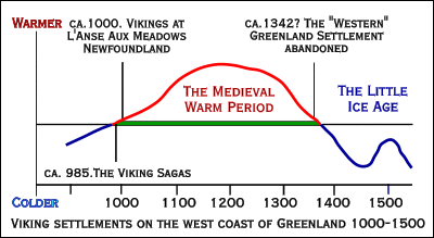
FIG. 5e. Medieval
Warm Period, Little Ice Age, and demise of the "Western" Greenland
Settlement
MALAISE – THE MAN WHO TRAVELLED TO AKILINEK.
This story has been collated from two separate copies, one of which was written down from the verbal narration of an East Greenlander. Akilinek signifies a fabulous country beyond the seas. (Introduction by Helge Larsen in Hinrich Rink. Tales and Traditions of the Eskimo, McGill-Queens University Press, Montreal, 1974:169 (Reprint of the 1875 edition, W. Blackwood, Edinburgh. Emphases supplied)
THE ANGAKOK'S FLIGHT TO AKILINEK.
The following three tales are here given separately, but nevertheless put under one number, their contents being, on the one hand, interesting with regard to the information implied about the art of angakut (plur. of angakok) in general, while, on the other, they are somewhat imperfect and obscure, so as to make it difficult to decide whether we have one or two original stories before us. The first was written down in North Greenland before 1830; the second in the southernmost part of Greenland, about 1860; and the last has been written down by the author himself from a verbal narration, but is given here only in an abridged form. Akilinek is the fabulous country beyond the ocean. (Introduction by Helge Larsen in Hinrich Rink. Tales and Traditions of the Eskimo, McGill-Queens University Press, Montreal, 1974:271 (Reprint of the 1875 edition, W. Blackwood, Edinburgh; emphases supplied)
Lastly, a short tale that is illuminating, puzzling and also (it would seem) highly condensed:
THE INHABITANTS OF AKILINEK.–Iviangersook, while travelling far and wide for some time, settled down in Akilinek, leaving descendants there. Many years after, some people from the farthest north, in crossing the ice, came to a crevice far off the coast, and said some talk with people who appeared on the opposite side and announced themselves as Iviangersook's descendants in Akilinek. The countrymen from each side{?} alternately enumerated all the products of their homesteads. (Hinrich Rink. Tales and Traditions of the Eskimo, Translated from the Danish; new introduction by Helge Larsen. McGill-Queens University Press, Montreal, 1974:169 (Reprint of the 1875 edition, W. Blackwood, Edinburgh; emphases supplied)
THE REINDEER-HUNTERS WHO NEVER CAME BACK
People over in Akilineq, the country on the other side of the sea, often did not return when they went out reindeer-hunting. (Knud Rasmussen THE PEOPLE OF THE POLAR NORTH: A RECORD. Compiled from the Danish Originals and Edited by G. Herring, illustrations by Count Harald Moltke. Kegan, Paul & Trench, Trübner & Co. Ltd. London, 1908.207; emphases supplied).
Hanbury's Ark-i-linik is Thelon River. This pseudo-Eskimo name for the river, which has induced Stefansson to make a fantastical comparison between this river and the Greenland legendary Akilineq, is due to a misunderstanding. The word means "that on the other side of something" and is used of the ridges on the south side of Thelon River, the camp being pitched on the north side, but, according to Eskimo usage, cannot be used for the river itself. (Kaj Birket-Smith, The Caribou Eskimo: Material and social life and their cultural position. The Report of the Fifth Thule Expedition, 1921-1924. Gyldenal, Copenhagen,1929:30)
CHAPTER I: OLD FRIENDS IN NEW SKINS
I HAD halted to thaw my frozen cheeks when a sound and a sudden movement among the dogs made me start.
There could be no mistake as to the sound,–it was a shot. I glanced round along the way we had come, fancying for a moment that it might be the party behind signalling for assistance; but I saw them coming along in fine style. Then I turned to look ahead.
I had often imagined the first meeting with the Eskimos of the American Continent, and wondered what it would be like. With a calmness that surprised myself, I realized that it had come. Three or four miles ahead a line of black objects stood out against the ice of the fjord. I got out my glass; it might, after all, be only a reef of rock. But the glass showed plainly: a whole line of sledges with their teams, halted to watch the traveller approaching from the South.
One man detached himself from the party and came running across the ice in a direction that would bring him athwart my course. Evidently, they intended to stop me, whether I would or no. From time to time, a shot was fired by the party with the sledges.
Whether the shots fired and the messenger hurrying toward me with his harpoon were evidence or not of hostile intent, I did not stop to think. These were the men I had come so far to seek from Denmark and from my familiar haunts in Greenland. Without waiting for my companions to come up I sprang to the sledge, and urged on the dogs, pointing out the runner as one would a quarry in the chase The beasts made straight for him, tearing along a top speed. When we came up with him, their excitement increased; his clothes were of unfamiliar cut, the very smell of him was strange to them; an his antics in endeavoring to avoid their twelve gaping maws only made them worse.
"Stand still!" I cried; and, taking a flying leap out among the dogs, embraced the stranger after the Eskimo fashion. At this evidence of friendship the animals were quiet in a moment, and sneaked off shamefacedly behind the sledge.
I had yelled at the dogs in the language of the Greenland Eskimo. And, from the expression of the stranger's face, in a flash I realized that he had understood what I said.
He was a tall, well-built fellow, with face and hair covered with rime, and large, gleaming white teeth showing, as he stood smiling and gasping, still breathless with exertion and excitement. It had all come about in a moment,–and here we were!
... These men, then, were the Akilinermiut,–the "men from behind the Great Sea," of whom I had heard in my earliest youth in Greenland, when I first began to study the Eskimo legends. The meeting could hardly be more effectively staged; a whole caravan of them suddenly appearing out of the desert of ice, men, women and children, dressed up in their fantastic costumes, like living illustrations of the Greenland stories of the famous "inland-dwellers." (Knud Rasmussen, ACROSS ARCTIC AMERICA: Narrative of the Fifth Thule Expedition, Greenwood Press, New York, 1969:3-5 (originally published in 1927 by G.P. Putnam’s Sons; emphases supplied)
CHAPTER VII: WITH NO EDITORS TO SPOIL
Out of fifty-two stories which I wrote down among the Padlermiut at Hikoligjuaq, no fewer than thirty were identical with ones I had already heard in Greenland, and this despite the fact that for thousands of years past, no intercourse had taken place between the two groups of people.
An unquestionable connection exists between the Greenlanders and their Canadian kinsfolk in the matter of story and legend. (Knud Rasmussen, Narrative of the Fifth Thule Expedition, Greenwood Press, New York, 1969:88 (originally published in 1927 by G.P. Putnam’s Sons; emphases supplied).
[ Where did the Naujan Eskimos come from, and what became of them? ]Looking now to the westward, we find in Alaska a race of big men, who hunt the whale, live in permanent dwellings on the coast, use the bola, make earthenware, and have almost the same types of implements generally as those we found at Naujan; old finds from Alaska also exhibit even more marked resemblance to the Naujan type. The Thule folk then, must have come from Alaska, this is beyond question. They spread in a mighty wave from west to east, reaching right across to Greenland. (Knud Rasmussen, Narrative of the Fifth Thule Expedition, Greenwood Press, New York, 1969:116-117 (originally published in 1927 by G.P. Putnam’s Sons; emphases supplied)
It soon becomes apparent that they link up in two directions across the Eskimo region; with Alaska on the one hand and Greenland on the other. At Thule, in northern Greenland, a find has been made, the oldest of any extent from the whole of Greenland, which points to precisely the same type of culture as that which we found at Naujan; and we have therefore called it the Thule type. Similar finds have been made both in west and north Greenland, and the Polar Eskimos of the present day are very much like these Thule folk in many respects. The Greenland Eskimos, then, must have passed through these central regions at a time when they were still inhabited by the Thule folk.
For my own part, I accept that the archaeologists may be almost correct concerning an initial west-to-east migration from Alaska to Greenland of the so-called Thule "about a thousand years ago." Where I differ in essence and in detail is that I find it difficult to accept the prevailing assumption that this movement took place spontaneously in the first place, and entirely without any Norse-based impetus or interrelationship in the second. Here again, one of the main indicators that lends support to the latter option is the location of Greenland's Ultima Thule itself, and more pertinently still, Norse indicators found to the north and to the west of Thule on Ellesmere Island. There is a sound reason for a Norse presence at such high latitudes in terms of a possibly swift and direct route (albeit a composite one) across the Arctic Archipelago and on through the Northwest Passage, with or without any assistance from the Thule.(1) There was an initial southward movement of Thule people along the west coast of Hudson Bay during the 12th and 13th centuries. This movement was an integral part of the original Thule expansion out of Alaska and across the North American Arctic. In the area of concern here it probably took people at least as far south as Churchill.
(2) Sometime during the centuries that followed, but prior to the beginning of the 17th century, the Thule population disappeared altogether south of Eskimo Point, and it was reduced substantially toward the north. Just why this would have happened remains a problem, but it probably had to do with the unstable climatic conditions of the 16th century, which probably reduced the local game supply (Burch 1978).
(3) Sometime later, in the 17th century, there was a migration of people from the Copper Eskimo area to the shores of Hudson Bay. The migrants were numerous enough to assimilate and/or exterminate their predecessors, with the result that their housing style and dialect quickly replaced the earlier forms without causing a break in the continuity of occupation. If this hypothesis is correct–and it is the only one yet advanced to account for such a wide variety of data–then the in situ transition model does not apply to the Caribou Eskimo area.
On a more general level, I question the conventional view that all historic Canadian Eskimo cultures developed in situ from an original Thule base. The historic cultures developed from a Thule [203] base, all right, but in a much more complex way than the in situ transition model would allow. I believe that future research will demonstrate that the central Eskimos in general just barely survived the little ice age of A.D. 1400-1850; only tenacity of purpose, considerable ingenuity, the invention of the dome-shaped snow house and a number of population shifts made it possible. It is remarkable that that view would be debatable. On a priori grounds it would seem extraordinary to have a population expand dramatically over thousands of miles of territory in the space of 300 years or so, as the Thule people did, only to have their descendants, who followed the same basic life style, essentially sit still for 700-800 years thereafter. The Canadian Arctic never was so densely inhabited for inter-regional population movements to be impossible or even particularly difficult. (Ernest S. Burch, Jr. THE THULE- HISTORIC ESKIMO TRANSITION ON THE WEST COAST OF HUDSON BAY. In THULE ESKIMO CULTURE: AN ANTHROPOLOGICAL RETROSPECTIVE, Ed. Allen P. McCartney, National Museums of Canada [Mercury Series] Ottawa, 1979:202-203).
All arctic communities have traditions and histories that tell of long journeys to both known and unknown destinations, usually in search of resources needed by communities under stress. The histories, however, almost never say when the journeys were made, or what the terminal points of the journey were. Some identify Akilineq as the goal of the journeys, but the place name is little help in identifying locations. One or two actual places are, or have been, known by the name; one such is the Akilineq Hills near where the Thelon River flows into Lake Beverley in the Northwest Territories. However, most references to Akilineq, which means "the place across," are to unknown lands, which heroes of the past often sought, sometimes found, and from which they usually returned.
The Ammassalik people of East Greenland have an especially extensive and detailed collection of histories that suggest that their ancestors, like the Coronation Gulf people, may have responded to problems of diminishing resources in the late sixteenth and early seventeenth centuries by attempting to reach unknown lands across the sea to the east. (Renée Fossett. IN ORDER TO LIVE UNTROUBLED: Inuit of the Central Arctic, 1550–1940. University of Manitoba Press, Winnipeg, 2001:75; emphases supplied)
From Greenland to the East
In the 1850s the Danish government commissioned naturalist Hinrich Rink to investigate the state of trade and government in its Greenland colony and, after receiving his report, appointed him Director of the Royal Greenland Trade. In 1861 he began publishing Atuagagqdliutit, the first Greenlandic language newspaper. One of his purposes was to provide a vehicle for Greenlanders to record their oral traditions and histories. In 1875 he published a selection of the stories, with comments about the nature and regulation of Greenlandic storytelling.
Greenlandic storytellers of the time made a clear distinction between two kinds of stories. Oqalugtuat (plural; singular is oqalugtuaq) were very old stories known almost everywhere from western Alaska to eastern Greenland, many of which have their counterparts in Siberia. The oqalugtuag often incorporated supernatural occurrences, and were intended to give instructions for proper living, rather than to relate facts about past events. Oqalualat (plural; singular is oqalualarut) were accounts of actual events, [76] often within living memory, but never more than 100 to 150 years old; that is, within five or six generations of their telling, and known only locally. One of the characteristics of western Greenlandic storytelling noted by Rink was that each story was prefaced by a clear statement of the category to which it belonged. Both kinds of stories made references to Akilineq, but not as just a distant and well-endowed place, as it is in the stories from other parts of the arctic. In the east Greenlandic oral tradition, in addition to being distant and rich in resources, it was also always a "country beyond the seas.''
In 1883 to 1885, Gustav Holm, ethnographer and leader of the Danish Polar Expedition to Ammassalik in east Greenland, collected a number of puzzling stories about visits the Ammassalik people of east Greenland had made to Akilineq. The references were even more specific than in the west Greenland histories. The people of Ammassalik consistently placed Akilineq "far out at sea towards the east" The animals there were said to be very big and the inhabitants not quite human. Because he was repeatedly told the clouds over Akilineq were distinctly visible from the Blosseville Mountains north of Ammassalik on a clear day, Holm concluded that the people were referring to Iceland.
Akilineq is the scene of the action in the well-known story of Kamikinak, an Ammassalik boy of notably small stature. One day, after his mother had called him "a puny good-for-nothing," he took his kayak out to sea. Eventually he arrived at an island where he met a very large man with strength enough to pluck both Kamikinak and his kayak out of the sea. The man became Kamikinak's foster father and took him to his home in Akilineq, where all the men were tall. In time, Kamikinak grew to similar size and then returned to his own country.
Another story, apparently (and perhaps significantly) known only in Ammassalik, concerns five brothers. The first brother went out to sea and did not return; the second went in search of him and also did not return. A third brother disappeared on the same errand. The fourth brother took up the search and also went eastward out to sea. While he was resting on the beach of an uninhabited island, he was discovered by one of his missing brothers. Together they went even farther out to sea until they lost sight of the island where they had met, and came to yet another island, the second in the series of islands in the story. The brother who had been missing did not live on this island, but he had left his sled and a dog team there. After travelling a great distance on the ice, and losing sight of the land where the sled had been, they came at last to Akilineq, the third island in the series. In a house surrounded by clouds, the brothers joined several other people [77] feasting on whale meat and ringed seal. None of the company felt satisfied by the meal. Shortly after, they were all sick. The fourth brother then returned to his own home, where the fifth brother had remained, and reported that all three of their missing brothers lived in Akilineq.
Holm also recorded stories of giants, the not-quite-human persons who appear in all Eskimo and Inuit oral literatures from Alaska to Greenland. One tale told to Holm at Ammassalik in the 1880s described houses with chimneys, an architectural detail unknown among Eskimo and Inuit except in Alaska and the Mackenzie River valley, but common in Iceland.
Scholarly research into the meanings of folkloric materials such as the Ammassalik stories is only just beginning at places like the Alaska Center for the Study of Native Languages. We still have very little understanding of how historical fact, prescriptive parable, and fictional embellishment are combined in oral traditions and histories, and almost no understanding of how to separate the various elements. Given our present state of understanding, we cannot identify historical material in the Ammassalik stories with any kind of certainty. What is clear is that stories about journeys eastward from Ammassalik into or across Denmark Strait were not especially rare. Some details in the stories suggest a degree of historical accuracy: the description of dwellings with chimneys; comments on the visibility of Akilineq from the Blosseville Mountains; the account of an ice crossing from one island to the next in the story of the lost brothers; and the account of a house surrounded by clouds, which could be a description of island fog. The Ammassalik stories fall into the category of oqalualarutit (in West Greenlandic, oqalualarut), which means they were intended as true histories of actual events that took place no more than five or six generations earlier; that is, within the past 100 to 150 years. Therefore, the actual events would date to a generation living around 1700.
(Renée Fossett. IN ORDER TO LIVE UNTROUBLED: Inuit of the Central Arctic, 1550–1940. University of Manitoba Press, Winnipeg, 2001:75-77; emphases supplied)
She had heard of Akilinirmiut, but always supposed (never was told) that they were ' Kitegaryum akiani,' i.e., across the sea (north) from Kittegaryuit. She heard it frequently told that the valuable beads came from the Akilinirmiut. This would make it seem likely that Akilinirk was Siberia,but [they had] never heard of such a name applied to any part of Siberia." (Wissler 1914: 331; emphases supplied).
... of whether the historic Salish culture, as Vancouver and Simon Fraser first saw it almost two hundred years ago, with its comparative simplicity and passivity, was nearer than the more elaborate and aggressive northern cultures to an original common coastal way of life out of which they all developed. Philip Drucker, one of the more important anthropologists to deal with this question, has suggested that there must have been a kind of primal culture founded by an early Mongoloid fishing and hunting people, who came across the Bering Strait land bridge from northeastern Asia and made their way down the coast towards California at the end of the Ice Age, about ten thousand years ago. He believes that both the Aleuts and the Alaskan Eskimos are descended from this original migration, and that among the Coast peoples, the Nootka and the Kwakiutl (who both belong to the Wakashan language group) are isolated representatives of the same heritage. But the Coast cultures, as we have known them in historical times, he believes to have developed as a result of the mingling of this original strain with two later streams of migrants who found their way south from the mountainous hinterland where they had already established themselves as hunting peoples the Haida, Tsimshian, and Tlingit descending the northern rivers, and the Salish coming down the Fraser. (George Woodcock. Peoples of the Coast: The Indians of the Pacific Northwest, Hurtig, Edmonton 1977:42–43; emphases supplied)
During the centuries that followed the waning of the Marpole culture around 400 A.D., other people and other influences seem to have moved into the Fraser Valley, until the situation stabilized round about 1200 A.D. with the culture particularly associated in the minds of archaeologists with the old village of Stselax on the Musqueam reserve near Vancouver, which all the available evidence suggests has been inhabited continuously for more than seven hundred years. The period from 1200 to Simon Fraser's arrival in 1808 seems to have been one of extraordinary cultural stability—even stagnation.
... Yet in two important respects the Stselax culture differed from that of Marpole. Mortuary practices changed from burial in the local midden to the custom—continued well into the nineteenth century—of wrapping dead people in mats or blankets and depositing them in grave houses outside the village or even in canoes perched in trees; only the shamans were still buried in the ancient way, but in their cases the burial was a good distance outside the village. This quite radical change of practice suggests the influence of some group moving in from outside the area, probably from the north (George Woodcock. People of the Coast: The Indians of the Pacific Northwest, Hurtig, Edmonton 1977:41–42; emphases supplied).
BIBLIOGRAPHY
Maps: Partial Map Listing
for the Last Viking
Postscript 1: A Fir Tree of the
Mind
(pdf)
Postscript 2: RongoRongo and the
Raven's Tail
OTHER: Easter Island
Stone Structures