Between 19I9 and 1927, a heated debate appeared in the pages of the Spokane Chronicle and Spokesman Review newspapers concerning the origin of Columbia Plateau rock art. No fewer than two dozen published articles expounded the views of Professor Oluf Opsjon, who argued vigorously that the carvings and paintings were runes documenting the exploration and colonization of the Plateau by Vikings at about A.D. 1000.while during the Fifth Thule Expedition (1921-1924) it was established that:
The archaeological site known as Naujan (called auyat by local people) is one of the most important of its time period. Here in 1922 Therkel Matthiassen, a member of the Danish Fifth Thule Expedition, conducted the first scientific archaeological investigations in the Canadian Arctic. He excavated twelve of the twenty house ruins and defined the culture of the people who had lived in them... The ancient occupants of these shelters are known as the Thule (pronounced Too-lee) people. Ancestors of the modern Inuit, they had migrated eastward across the Canadian Arctic from Alaska about 1000 years ago. They settled at Naujan around A.D. 1200, and were hunters of the great bowhead whales. (The Prince of Wales Northern Heritage Center: Naujan: Repulse Bay )Twelve out of twenty house ruins? What became of the rest, and was this sort of data and that obtained from other Thule sites (e.g., Nunguvik) sufficient justification to define a new culture in the Arctic? Apparently it was, for Mathiassen's 1920's Thule-Alaskan concept was happily embraced thereafter with the Northwest Passage effectively sealed shut by the accompanying west-to-east incursions of the "Thule" peoples. Moreover, all subsequent settlements have also been explained in terms of this same Thule culture. But even so there are a number of problems with the suggested influx of Alaskan Inuit whalers into the Eastern Arctic. Firstly, Peter Schlederman (1981:594) has pointed out that the notion of Whaling as a primary Thule activity is not necessarily supported by the available evidence, at least on Ellesmere and Skraeling Islands:
Although some of our later discoveries on Skraeling Island confirm the practice of whaling, I believe that its importance has been exaggerated. Baleen and whalebone are durable items, and they were obviously reused in Thule house construction. I estimate that all the whalebone in the Bache Peninsula represents a total of no more than 30 or 40 whales. Since the Thule culture flourished on Ellesmere Island on and off for about seven centuries, whaling hardly seems to have been a mainstay of the economy. (Peter Schlederman, "Eskimo and Viking Finds in the High Arctic," National Geographic Magazine, Vol. 159, No. 5, May 1981:594)Secondly, the notion of large scale Inuit movement over such vast distances - literally thousands of miles from Alaska to Greenland - is at odds with the knowledge and experience necessary to survive in these harsh and unforgiving regions. It is not by chance that the Inuit refer to themselves in terms of a predominant activity, or people of a specific area, i.e., Netsillingmiut - "People of the Seal" as explained by Rachel Qitsualik, who lists more than 60 such groups in her Inuit Map of Nunuvut and the Northwest Territories. These specialized and localized names reinforce the realization that it is would be a major undertaking to leave a known ecological niche with well-established seasonal rounds for an entirely new one. Yet for the Alaskan Inuit to have reached the west coast of Greenland this would have to have taken place each time they moved, and in each instance there would still be the ever-present necessity of having to prepare and provide for the long arctic winters. Nor should this be confused with traditional local movements between summer and winter camps in known environments. So perhaps a few Alaskan Whale hunters moved east from time to time, but that far and in sufficient numbers to replace the Dorset peoples in the Eastern Arctic? Hardly likely. So what did happen?
MAP 1b. THE SHORT-HAUL ROUTES TO NORTH AMERICA
Then there is the
likelihood of early exploration
into and around Hudson Bay, connecting up with the various river
systems there - the Missinaibi and the Albany down to the Great Lakes,
for example, south and southwest via the Severn and Nelson, or westward
via the Churchill and the Saskatchewan Rivers (for the Nelson River,
see: Michael A. Zalar's Cartographical
Speculations and a short discussion concerning a possible Viking
journey south via Hudson Bay). Here one would not require the Northwest
Passage
at all, simply the route into Hudson Bay itself. Moreover, even in the
present century a conservative estimate of over 100 days between July
20 and November 1 is available for safe navigation through Hudson
Strait to the port of Churchill (see: "The Possibilities of the Hudson
Bay Company," National Geographic Magazine, Vol. XVIII, No. 3,
1907:209).
Moreover, given relatively easy access
into Hudson Bay it seems reasonable to suggest that exploration into
the heart of North America could have been attempted around or
shortly after the time of the Sagas, i.e., "about a thousand years
ago." In view of the lengthy period under consideration, however,
(from at least 1000 to 1250 CE) it would be difficult to put a limit
on just how far such expeditions might have travelled, let alone what
may
or may not have resulted. Nevertheless, there might still be a few
residual indicators, e.g., in the occurrence of pre-industrial ceramics
in the Canadian Provinces that provide the suggested access to the
western interior via Hudson Bay itself. Here at least the time
element is correct (if not almost familiar), i.e., the text accompanying Civilization.ca's "Gather
Around this Pot - South Indian Lake, Manitoba presentation states:
This is a shallow ceramic container that has been interpreted as a plate or possibly a lamp. It was found in 1971 at site HiLp-3 on Southern Indian Lake in Northern Manitoba ... These artifacts are quite distinctive and limited in distribution to Northern Manitoba where they are part of the Kame Hills Complex, an archaeological culture dated to between 250 and 1100 years ago and believed to be ancestral to the Cree people who inhabit the region today. The shallow container is decorated with the same basic elements as are found on the more numerous globular pots (for example see Exhibit Specimens 6 and 7). The upper surface of the rim is marked with a double row of punctates which raised bosses on the opposite surface. Similarly, there is a pattern on the plate made with punctates whose meaning is open to interpretation. (emphases supplied)
The location of the Manitoba site (A) is shown below. Site B (in Saskatchewan) is similarly described in "Gather Around this Pot - Amisk Lake, Saskatchewan as follows:
This is a ceramic container of a variety known as Clearwater Lake Punctate. It was found on Whitefish Island on Amisk Lake, Saskatchewan in the 1950's by Gina Sewap, of the local Cree First Nation. Its distinctive features include an encircling ring of exterior punctates which raise interior bosses, located just below an everted lip. The body of the pot is textured with cord or textile impressions. Pots of this variety are found over a wide area including parts of Eastern Saskatchewan, Manitoba and Northwestern Ontario. They were being made during the late prehistoric period, dated to between 250 and 1100 years ago. These ceramics are believed to be ancestral to the Cree people of that region. (emphases suppplied)
Map 2d. Pre-Industrial Era Ceramics in Manitoba (A), Saskatchewan (B), and NW Ontario
Thus, though perhaps
coincidentally, ceramic
items of
the type reported above occur in regions that provide lengthy routes
into the Interior from Hudson Bay via major western rivers, notably the
Churchill and the Saskatchewan to the west, with other river routes (red on Map 2d) also available
to the south.
Before moving on it is appropriate here to suggest that although the importance of river transportation in North America has been acknowledged, the significance of coastal routes and the potential for connecting with the former has been largely under appreciated. Yet rivers have long provided the means for covering great distances in relatively small vessels that depend almost entirely on rowing or paddling (in the present context see: Canoe Saskatchewan Waterways) . Here one might suggest that greater emphasis should be placed on the historical importance of all major North American river systems. In addition to the Hudson Bay rivers mentioned above, we may include the Mackenzie and Yukon rivers in the Northwest, the Fraser, the Columbia and the Snake from the West Coast, east of the Rockies the Bow River and the Qu'Appelle to Lake Winnipeg, and the Red River of the North down to Minnesota. Then there are the Missouri, the Colorado and the Arkansas rivers of the Western Interior, and further east the Ohio and the mighty Mississippi, as indeed already emphasized by Gloria Farley in her 1994 publication In Plain Sight (see especially Chapter 2: They Came in Ships).
In general it may be
observed that apart from the
St. Lawrence, eastern rivers are not necessarily that useful for deep
inland
excursions into North America. Thus when archaeologist Robert McGee
writes:
"The Vikings got here first, but why didn't they Stay?" (Canadian
Geographic
Magazine, August/September 1988) a partial answer might be that as
far
journeying inland was concerned, the Hudson Bay route may have been
preferred
- whether approached via the Greenland and Ellesmere Island coastlines,
or
into Hudson Strait from Greenland across the Davis Strait. Or even
continuing
down the Eastern Seaboard, around Florida and into the Gulf of Mexico
to
the Mississippi Delta and on perhaps to Mexico, and - all difficulties
and
hardships notwithstanding - through the Northwest Passage for the
Pacific
Northwest and beyond, both to the west and to the south. Lastly, since
neither
the destinations nor the agendas associated with the sudden departure
of
the Vikings from Greenland are known, the assumption that they crossed
to
North America and simply settled there may itself be only part of a
more
complex equation. Perhaps some did stay, but not necessarily in great
numbers
in the east, or again, perhaps others moved further and further south
on
both sides of the continent. Unlikely premises to be sure, yet the
possibilities
nevertheless remain, even if they are at odds with prevailing
viewpoints
on the matter.
THE WAY WEST: THE
BLOCKED PASSAGE.
Collecting the various indicators mentioned in
previous sections, even at this early stage nagging questions begin to
arise--not
least of all how is it that so little real progress has been made with
respect to possible Viking incursions into the northern regions of the
Americas. Their
presence on this continent was after all recognized as long ago as the
1960's
following Helge Ingstad's discovery of the Viking settlement at L'Anse
Aux
Meadows in Newfoundland. One would have surely expected a major
increase
in interest and concerted efforts to determine where else the Vikings
may
(or may not) have landed-- at least on the eastern shores of Canada, if
not
further inland. But unfortunately and for whatever reason, very little
in
the way of positive action in this regard appears to have taken place,
or
perhaps better stated, what has been done since that time has either
been greatly minimized or largely ignored.
But in any event, once the Vikings were established
on the west coast of Greenland at the end of the first millennium it is
reasonable to suppose that they would have explored the potentials of
the Labrador/Ungava Peninsula region quite early on. Furthermore, given
the proximity to the Treeline
and the availability of game, wildfowl, marine animals, etc., hunting
sites--both
short and long-term-- might reasonably have become small,
semi-permanent settlements
with or without the assistance of the local Inuit. It would therefore
seem
a logical step to investigate such possibilities and look for signs of
passage
there, if nothing more. As it happened, excavations on the west side of
Ungava
Bay carried out in the 1950s and 1960s by Canadian archaeologist Thomas
Lee
did indeed suggest a Norse presence in the region (see Map 2a
and Lee's published research in the bibliography). But although Lee's
investigations
preceded Helge Ingstad's1961 discovery of the Viking settlement at
L'Anse
Aux Meadows in Newfoundland and also continued parallel with it, no
great
interest appears to have been developed concerning the possible
presence
of the Norse in either northern Labrador or the Ungava region. While it
cannot
be said that Lee's material was suppressed per se, it hardly
seems
to have been entirely welcome either, and even now it appears to be
largely
ignored. In fact it seems likely that it would have remained that way--
detailed
inclusion in James Robert Enterline's VIKING AMERICA (1972)
notwithstanding--had
it not been for Farley Mowat and his recent book: The Farfarers
(Seal
Books, Toronto,1999) which in effect made Lee's findings and
conclusions
available to all.
Then there is the major site at Native Point on Southampton Island to be considered--a place that would have been a logical continuance for Vikings westbound across the top of Hudson Bay from the Ungava Region. Major site? It would seem so, and a major oddity into the bargain in terms of its limited excavation and subsequent position in the general scheme of things. Writing in the November 1956 issue of the National Geographic Magazine Henry B. Collins (anthropologist for the Smithsonian Institution) describes his 1954 visit to the Native point as follows:
In all my years of Eskimo archaeology I had never seen anything to compare with the ruins that lay before me. Some 90 semisubterranean dwellings, the largest aggregation of old Eskimo house ruins in the Canadian Arctic, spread over a 30-acre expanse. Jumbles of stone from walls and roofs filled the sunken interiors and entrance passages of the best preserved houses. Of others, only slight depressions in the grassy terrain remained. Skulls and bones of animals eaten by the Sadlermiuts, mostly seals, caribou, and walruses, littered the ground outside the ruins. Hundreds of stone cairns and meat caches stood near the site and ranged about it for miles around. More than 100 human burials dotted the vicinity. Usually the bodies rested in carefully constructed stone vaults, but some lay on the surface with only a surrounding enclosure of stones. To excavate the site completely would have required an army of archaeologists. We would be able only to sample it, digging just enough to obtain a rounded picture of the material culture and way of life of the Sadlermiut Eskimos. (Henry B. Collins, "Vanished Mystery Men of Hudson Bay," National Geographic Magazine, Vol. CX, No. 5, November 1956:669-686, emphases supplied).What became of the Sadlermiut of Southampton Island? The all too often tragic story of contact, disease and ultimate disaster it would seem, as Collins explains:
Victims of pestilence after pestilence, the Sadlermiuts numbered scarcely more than 70 survivors in 1896. Then, in the summer of 1902, a ship stopped to trade at Cape Low, Southampton Island. Sadlermiuts who came in contact with the crew contracted disease. Carried home to Native Point, they infected the last remnant of the Sadlermiuts. Visitors to Native Point the following winter found a scene of death. Not an Eskimo had survived. Some lay in their houses on sleeping platforms; others on the ground outside, where their dogs still ran about. In a corner of one of the stone ruins I found the tiny skeleton of an infant and imagined its last futile wailings for a mother who could no longer tend her child.("Vanished Mystery Men of Hudson Bay," National Geographic Magazine, Vol. CX, No. 5, November 1956:674).So passed the Sadlermiut--an unusual people who spoke an unusual dialect, and also, it would seem, people who originally came from Baffin Island to the east. As for Native Point, it cannot be said that it was completely ignored either, for Dr. William E.Taylor (a Canadian archaeologist who accompanied Collins on the 1954 trip to Southampton Island) published a paper on the site under the auspices of the Canadian Museum of Civilization in1960. As Farley Mowat recounts in the FarFarers (1999:267-273, see below) Taylor subsequently took over from Thomas Lee and also worked on some of the Ungava sites, but he seems to have done did little more to investigate the suspected Norse presence there, or indeed actively support the notion. A few years later in the 1960's the same William E. Taylor also participated in the on-going excavations of the Viking settlement at L'Anse Aux Meadows in Newfoundland. It seems unlikely that the subject of other Norse locations in eastern Canada did not crop up during this time, and that Taylor--who had visited both Native Point on Southampton Island and the Ungava Bay region as an archaeologist--would not have been eagerly questioned about this. Given the subsequent lack of interest in these lower arctic regions, one can only wonder what Taylor--subsequently lauded as "Canada's first professional Arctic archaeologist"--may (or may not) have said on this particular subject. But either way it seems to have done him little harm. As Farley Mowat records: "In 1967 Dr. William Taylor became director of Canada's National Museum of Man, a post he held (as director, then as director emeritus) until 1994, when he died, full of honours and distinctions." (The FarFarers, Seal Books, Toronto, 1999:273).
The museum was subsequently renamed the Canadian Museum of Civilization; in an April 2000 the institution announced in the following communique that:
Several months ago, archaeologist Patricia Sutherland discovered specimens of spun yarn, as well as artifacts showing traces of unusual woodworking techniques, from the remains of the Palaeo-Eskimo settlement of Nunguvik on northern Baffin Island. She has since found similar collections of yarn and worked wood at three other Baffin Island sites over 1,000 kilometers south of Nunguvik, and what appear to be comparable specimens have also been reported from a site in northern Labrador. All of these sites were occupied by Dorset culture Palaeo-Eskimos, who inhabited the Arctic before the arrival of the Inuit beginning about a thousand years ago.What this release fails to mention, however, is that the pieces of spun yarn and wood from Nunguvik were discovered in the 1980's and that they had been sent to the museum years ago where they remained neglected and unprocessed. It was only Sutherland's expertise gained in Greenland on one hand and her diligence in recognizing the similarities of this material when she recently came across it on the other that brought the matter to light. The positive actions that followed are encouraging, but it is difficult to agree with the first part of the release that claims: "This project has the potential to tell a chapter of Canadian and North American history that was not previously thought to exist." The statement completely downplays the discoveries of Norse items in the High Arctic made by Peter Schlederman in the 1970s (see the latter's: "Eskimo and Viking Finds in the High Arctic," National Geographic Magazine, Vol. 159, No. 5, May 1981; also below) and also makes no mention of the many sites investigated by Thomas Lee in the Ungava Region alluded to earlier--the results of which have long been available (see the Bibliography below).
Since neither the Palaeo-Eskimos nor their immediate Inuit successors spun yarn or worked wood by sawing, nailing and morticing, the artifacts pointed to another culture. These technologies are characteristic of medieval Europe, including the Norse farming society which developed in southwestern Greenland between approximately A.D. 1000 and A.D. 1450.
Previous evidence of Norse contact with the Aboriginal peoples of Arctic Canada has been limited to fragments of metal or other artifacts that could have been obtained through brief coastal trading contacts. The material which Sutherland has discovered suggests a more extensive association by Europeans with the people of Baffin Island and adjacent regions and possibly a degree of contact which was sufficiently intense to influence the technology of the local people. Radiocarbon dates on samples of spun yarn and other specimens also suggest that a European presence in Arctic Canada may have begun earlier than previously thought. One of the first challenges of the Helluland Archaeology Project will be to assess the date of the apparent European material in the region. ("New archaeology research project explores possible early European contact in Canadian Arctic," Canadian Museum of Civilization, April 25, 2000, Hull, Quebec)
Leif Eiriksson's successors in Greenland eventually vacated that land and spread throughout North America, as far as Alaska, meanwhile sending to Europe geographical information that sparked Columbus' voyage." (Robert James Enterline, VIKING AMERICA The Norse Crossings and their Legacy, DoubleDay, Garden City, 1972:xviii).No doubt these were major points of contention almost guaranteed to be opposed by champions of the status quo when the book came out. To make matters worse Enterline also included a third--the first part of the work itself, namely a possible location for Vinland on the west side of Ungava Bay. Say what one will--agree or disagree--it was a thoroughly researched, detailed approach to the subject. As indeed was the entire book--the second part of which still likely remains one of the most detailed scholarly discourses on the question of prior knowledge of the Americas by and before Columbus.
With their ships, the Norsemen could in one or two summers make the voyage between Alaska and Greenland which had taken the Eskimo people centuries to accomplish. It is not really necessary to have steel-bowed supertankers with gigantic engines to sail through the Northwest Passage so long as one does have patience, understanding of ice conditions and skill in ship handling (Robert James Enterline, VIKING AMERICA The Norse Crossings and their Legacy, DoubleDay, Garden City, 1972:91).Naturally enough, in pursuing his thesis concerning the western side of Ungava Bay Enterline paid due attention to archaeologist Thomas Lee's findings there. Furthermore, in pursuit of the suggested westward expansion of the Norse across the Canadian arctic he also covered a further contentious issue--the possibility of inter-marriage between the Norse and the Inuit, noting the controversy such suggestions had generated in the past:
A subject that goes hand in hand with the question of mutual interaction of the Norse and Eskimo cultures after a hypothetical permanent move to the central Arctic is the question of interracial mixing. Ever since Viking times the Norsemen have left their genes behind at places they visited, and the question is not one of whether or not mixing took place. Rather, the question is whether it took place to such an extent that the ultimate disappearance of the Norsemen can be attributed to their complete absorption into the Eskimo race. When two different races occupy the same territory they tend to maintain their racial separateness so long as they maintain their cultural and economic separateness. But once the different cultures have become amalgamated, many of the taboos against intermixing disappear. In 1942 Knud Fischer-Moller reported the finding in a Greenland church graveyard of two skeletons having features that prove that mixing was not unheard of even in the settlements. The political infusion of Germanic studies during the second quarter of the twentieth century may have prevented some Teutonic scholars from considering this question rationally, but before that time there were many adherents to the theory that the Norsemen had been completely absorbed into the Eskimo race. As early as 1776, an Icelandic scholar propounded the theory of racial absorption, and around the turn of the twentieth century this came to be known as the Nansen Theory. The trouble with this theory was that it was based primarily upon inductive speculation rather than upon much explicit evidence. Then in the early 1900s a discovery by the adventurer Klengenberg and investigations by the anthropologist Vilhjalmur Stefansson brought to light the apparent presence of European genes among a small group of Eskimos who had previously been isolated from all contact with modern white man. This tribe, known as the Haneragmiut, lived at the heart of the region I have just been discussing, in southwest Victoria Island. Entries in Stefansson's diary include descriptions such as:
' There are three men here whose beards are almost the color of mine, and who look like typical Scandinavians . . . men with abundant three-inch-long beards...The faces and proportions of the body remind of "stocky," sunburned, but naturally fair Scandinavians ...One woman, of twenty, has the delicate features one sees in some Scandinavian girls, and that I have seen in only one of the half-white girls to the westward (Mackenzie River), and in her to a less degree than here.'
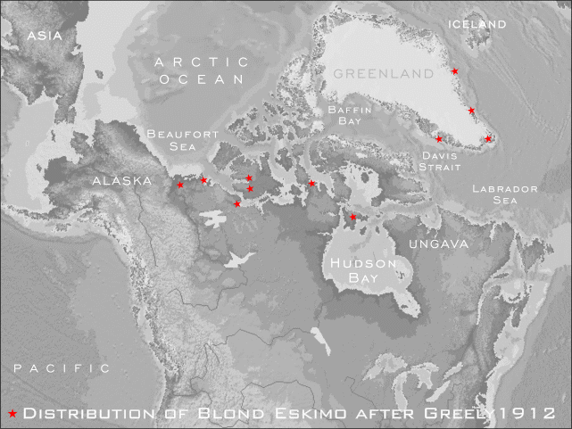
That such copy would be overplayed by newspapers is completely understandable, and these people were immediately dubbed the "Blond" Eskimos. Soon Stefansson was being confronted with accusations of fraud no less vehement than those that met Stanley when he announced his finding of Livingston. Even Stefansson's professional stature as an anthropologist was brought into question when a specialist in ethnology on a later expedition, Jenness, was apparently unable to locate this tribe. Furthermore, Jenness tried to explain any such characteristics which might exist as pathological deformities, and noted the absence of any European skeletal features. The controversy then quickly escalated when Jenness' own scientific method as well as the accuracy of his observational reports were called into question.Enterline's ameliorating closure notwithstanding, the critics still seem to have had their way, with the subject rarely broached or even acknowledged up to the present day. Perhaps it is still a polarized issue, but even if Stefansson's original material is bought into question it remains difficult to dismiss the reports of atypical (if not European) featured Inuit encountered by many early arctic explorers. This aspect was in fact well exemplified by Major General A.W. Greely in a 1912 paper entitled: "Stefansson's Blond Eskimos" (National Geographic Magazine, Vol. XXIII, No.12 December 1912:1225-1238). The title may have been a trifle unfortunate, but the quotations themselves seem stark enough, and it is hard to imagine that the principal recorders--many of whom left their names across the Canadian Arctic--would have had any reason to be untruthful about what they saw and recorded; e.g.,
Certainly to use Stefansson's observations as an argument for the ultimate absorption of the Norsemen into the Eskimos is, in any case, going too far, for there is not available any dependable knowledge of the relative population levels of either the Norsemen or the Eskimos at the time. Even to use the "Blond" Eskimos as an argument for the very presence of Norsemen in the central Arctic is going too far without more agreement among anthropologists. The entire subject of Eskimo anthropology is a highly factionalized and controversial one, and a not-too-out-of-date survey of the relevant literature has been given by Maksim Levin. In any case, modern studies of genetic drift make it clear that one must hesitate about jumping to conclusions when dealing with such small populations. (James Robert Enterline, VIKING AMERICA, Garden City, 1972:135-138; emphases supplied).
1821 Sir Edward Parry on the shores of Lyon InletNoteworthy here are the references to Coppermine and Prince Albert Sound, i.e., those regions originally associated with Stefansson's "Blonde Eskimos" as shown below in Map 5a-- a wide range of locations that extends from the east coast of Greenland, through the Northwest Passage and Canadian Arctic Archipelago almost as far West as the Yukon coast:
1821 Dr. Alexander Fisher, surgeon of Parry's expedition
1824 Capt. G. F. Lyon, near Cape Pembroke, Southampton Island.
1833 Capt. John Ross in his journey to Back River.
1821 Sir John Franklin, near the mouth of the Coppermine River.
1837 Thomas Simpson, west of the Mackenzie River.
1838 John Dease on the lower Coppermine River.
1838 Thomas Simpson near the mouth of the Coppermine River.
1848 Dr. Richardson during his "boat journey through Rupert Land."
1849 Dr. John Rae.
1825-1827 Sir John Franklin in the Cape Bathurst region.
1851-1852 Capt. R. Collinson, in Walker Bay, Prince Albert Sound.
1865 Pere Emile Petitot, Cape Bathurst.
1868 Pere Emile Petitot, Fort MacPherson (on the Peel River).
Dr. Alexander Armstrong, surgeon of McClure's ship Investigator, who found that:
"the Eskimo of Wollaston land were living under the same conditions as when visited by Stefansson."
Map 5a. The Distribution of the Blond Eskimo (after Greely 1912)
In November of 1913, two Oblate priests, Jean-Baptiste Rouvière and Guillaume LeRoux, were murdered by Inuit near Coppermine. The crime, caused by misunderstanding on the part of the Inuit and insensitivity on the part of the priests, was investigated and two Inuit were taken to Edmonton in 1917 for trial. They were sentenced to life imprisonment at Fort Resolution, but were released in 1919. An inevitable result of this case was the establishment of new police posts and the undertaking of regular patrols in the region.No necessarily invited guests, it would seem, which makes one wonder about the reception of the first priest to visit the Cowichan Valley on Vancouver Island (the suggested location for Vinland in the present hypothesis). He too, it seems, outstayed his welcome, though not quite so forcibly in this case:
It is uncertain where or when the first Europeans set foot in the Cowichan Valley. The first recorded presence was that of Reverend Father Honoré-Timothée Lempfrit, a Roman Catholic missionary who arrived at the mouth of the Cowichan River in 1850... Although he was probably encouraged to travel to the region at the invitation of Chief Tsulchamet, by May 1852 he ran into difficulties with the Cowichan First Nation and was ultimately driven from the valley... The cause of Father Lempfrit's problem has never been fully discovered, but it was serious enough that James Douglas upon hearing from the Cowichan themselves immediately ordered a canoe sent to retrieve the priest. Douglas later felt compelled to discourage "the hasty zeal of the Roman Catholic Missionaries" in Cowichan traditional lands. (Daniel P. Marshall, THOSE WHO FELL FROM THE SKY: A History of the Cowichan Peoples, Rainshadow Press, Duncan, 1999:96-97).Unfortunately, in the Pacific Northwest the tide of "progress" washed in more and more outsiders, and with them came the inevitable contagious diseases from which the local populations had little or no immunity. The result was the 1862-63 smallpox epidemic in British Columbia, which started after a ship from San Francisco docked at Victoria, British Columbia in March 1862 (Marshall, 1999:123). Although the fatality rate in the province was reportedly as high as 62 percent, losses among Haida of the Queen Charlotte Islands were far worse, for they were to receive a double visitation. A 1999 television program on Nan Sdins Park by the Historylands series described what took place there during the last month of 1863:
Trade with the White Man may have brought greater prosperity, but it also brought diseases--measles, diphtheria, cholera and chicken pox. The true devastation was still too come--the introduction of smallpox into the community was documented by Francis Poole, a miner at SkinCuddle Inlet:Further south the Coast Salish were among those who gained a measure of protection by way of vaccines during the1862-63 outbreak, but even so it seems that there were some already willing to consign them to past history, as Daniel P. Marshall reports:"December 1863. At New Aberdeen we had compassionately taken a European on board as a passenger via the Queen Charlottes to Victoria. As ill-luck would have it, what should he do but fall sick of smallpox some days before we arrived at the coppermine. I entered a vehement protest against his being put on shore, knowing only too well the certain consequences. Scarce had the sick man landed when the Indians again caught it, and in a very short space of time, some of our best friends of the Nan Sdins had disappeared forever."
Over ninety per cent of the population died. The prosperous village was decimated to the point that it was no longer viable as a permanent settlement. By 1884 there were only thirty former inhabitants encamped there."
(see also: Page 5; Gwai Haanas National Park by Great Canadian Parks )
An examination of the "Committee on Public Expenditure" Report, 3 May 1864, reveals that $9700 had been budgeted in 1863 and 1864 for the express purpose of extinguishing First Nations' claims to the Cowichan, Chemainus, and Saltspring Island Districts, monies that were never spent. One suspects that with the full impact of the 1862 smallpox epidemic having taken its terrifying toll on the Cowichan Nation, the colonial government held back these funds, perhaps believing that they were witnessing the end of the people. A British Colonist article from 1866 lends credence to this commonly held Hwunitum' view of the time.
The grasping avarice of the white man and the seizure of Indian lands has been the cause of internal wars and troubles in other countries and may perchance be the same in this. Should such happen, where would be the advantage of the supposed white settlement upon this coveted land? ... The Indian lands must be kept for the Indians, and the Government should, by every means in its power, induce them to cultivate their patches... who begrudge them a few acres for his necessities? It is probably true that the race is destined to disappear, not so much from its own fault as the vices that have been brought into it by the 'chosen people;' but for heaven's sake let us not make the years they have to live those of misery, or inductive of revenge, but seek to assuage the troubles, so as to enable the last man to sit down by the placid stream of the Cowichan, and sing of his ancestors, lament the loss of the tribe, but at the same time say, God's will be done! (Source: Daniel P. Marshall. THOSE WHO FELL FROM THE SKY: A History of the Cowichan Peoples, Rainshadow Press, Duncan, 1999:116).Home truths and fine sentiments, though patronizing, but as for the last line--God's will be done? In this appalling context? Small wonder that Alexander von Humbolt, on witnessing a South American slave market condoned by European priests in 1800 should observe: "Religion is able to comfort people for wrongs performed in its name" (Smith, 1990:230). And little wonder again, that most who have read the various journals of "Conquest" in the "New World" can feel anything but abject shame and horror at the atrocities inflicted time and time again against innocent peoples. Peoples whose only crimes were that they held different beliefs and occupied rich territories desired by those who arrived with superior weapons, self-justifying dogmas and scarcely a shred of human decency among them. At which point it seems relevant to return to the question at hand, i.e., why the Greenland Vikings departed when they did, where they might have gone and what they may have attempted to accomplish in doing so.
THE
GREENLAND DUALITY I
Returning to the Vinland issue, for the reasons
stated earlier and those that follow here I do not intend to give a
blow-by-blow account of the Viking Sagas or their attested variants,
nor do I intend
to dispute in depth other interpretations of them or the suggested
locations for Helluland, Markland and Vinland.
Instead I have adopted the view that if a duality existed in the case
of
Helluland that it may have been more than mere poetic licence and that
the
duality was likely far more extensive in addition. The concept of
duality
does not originate here, it was in fact discussed by Joseph Fischer
some
years ago in an entry in the Catholic Encyclopedia entitled: PRE-COLUMBIAN
DISCOVERY OF AMERICA :
History is silent as to later voyages to Helluland, but the role played by the Land of Stone is all the more important in legend and song, in which its situation changes at will. The Helluland of history lay to the south of western Greenland, but the poetic Helluland was located in northeast Greenland. To reconcile both views, Bjorn of Skardza devised his theory of two Hellulands, the greater in northeastern Greenland, and the smaller to the southwest of Greenland. Rafn arbitrarily located greater Helluland in Labrador, and the lesser island in Newfoundland. (Joseph Fischer: Pre-Columbian Discovery of America, transcribed by Michael Donahue; emphases added).The last two allocations notwithstanding, the notion of duality provides a functional fit for the present hypothesis, particularly the Helluland located "to the southwest of Greenland" when it is understood that "Greenland" is North America and that it is the West Coast of North America that is under consideration. Thus it is suggested that a true duality may well have existed throughout to protect and preserve those Vikings who had left Greenland in defiance of the Church. Or alternatively, that the confusion was injected by the Church itself to mask the reality of the Vikings' deeds and the scope of their endevours. But either way, there are names that are indicative or descriptive, names that commemorate events, and some that honour groups and individuals. But now and again there are names that simply do not fit at all, such as "Greenland."
It is as rational to call this Iceland as it is to call an ice-sheet measuring several hundred thousand square miles Greenland...Thus based on salient features:
Iceland is the centre of a sub-ocean volcanic region, and no region of Earth has an equal title to be called the "Land of Fire."
(John Stefansson, "The Land of Fire," National Geographic Magazine, Vol. XVIII, No 11, Nov 1907:741-742.)
Modern Iceland becomes "Fireland," as befits it.and green the latter it assuredly is in many locations, particularly in the Pacific Northwest. Moreover, with this configuration Helluland, Markland and Vinland still lie to the west of "Greenland," as do the "Bear" islands, "Wonder Beaches," "Keelness," the mild climate and all the fauna and flora referred to in the Sagas, including the salmon, halibut, whales, timber, wild wheat, and not least of all, the grapes representative of Vinland itself--to be precise, the Oregon-grape, specifically, Tall Mahonia (Mahonia aquifolium ) that still grows in the Cowichan Valley in the southwest corner of Vancouver Island--where the Cowichan Lake region is: "the Warm country," or, "land warmed by the sun." (G.P.V and Helen Akrigg, British Columbia Places Names, 3rd. Edition, UBC Press, Vancouver, 1997:54)
Modern Greenland becomes "Iceland," as befits it.
Modern North America becomes "Greenland," as befits it.
Thus the suggested Fireland-Iceland-Greenland shift does surprisingly little to the Sagas in a negative sense. In fact, certain aspects of the geographical side of the matter now begin to fall into place. For example, the west coast location for Vinland remains in accord with Adam of Bremen's understanding as early as 1070 CE, that Vinland was to the west of "Greenland." Moreover, there is the strange fact that although there are Eastern, Middle and Western Viking Settlements on present-day Greenland, all three are in fact located entirely on the west coast of the island. But from the shift in perspective suggested here, this is not "Greenland" anyway, but simply "Iceland," which might well explain why this peculiarity exists. It also provides a new insight into the often quoted criticism levelled at Eirik the Red, namely that he deliberately overstated the virtues of the new "Green" land to encourage settlers to move there from "Iceland." Here again the shift in perspective suggests that Eirik the Red was entirely truthful, and indeed even a settlement on the west side of Ungava Bay a little further south would have been a vast improvement, for here one would not only be below the Arctic Circle, but also near the Treeline and regions where both freshwater fish and caribou would be plentiful.
Then there is the question of what effect this might have on reports of specialized trade items obtainable only from "Greenland." Even without this complication Viking ships must surely have plied arctic waters beyond the "Western" Settlement if only to get to the northern hunting grounds, not to mention round-trips to Iceland and Scandinavia to trade their shipments of rare northern goods, i.e., ivory, skins and birds of prey fit for kings alone, the Gyrfalcons. Then again, perhaps the scarcity was also a function of the Greenland Duality, for as far as the trade in the latter was concerned Kirsten Seaver states:
Difficult to catch even in Greenland, gyrfalcons were worth a fortune by the time they reached Europe; the Duke of Burgundy is said to have ransomed his son from the Saracens as late as 1396 for twelve Greenland falcons. In 1276, just when Archbishop Jon was fine-tuning his laments, the Norwegian king sent the English king a princely gift of three white and eight grey gyrfalcons, a large number of ermine pelts, and a complete whale's head with all the baleen still attached. In the spring if 1315, Edward II of England sent a man to Norway to buy falcons and hawks--hardly a sign that these birds were now a glut on the market.That "Greenland" Gyrfalcons appear to have been a high demand, low availability item seems indisputable, yet invoking the "Greenland Duality" it is a simple matter to find a likely source, one that naturally enough is located on the "green land" that is North America. Nor is it a matter of scouring maps either, the answer is clearly indicated in archaeologist Thomas Lee's neglected work concerning Norse indicators on Ungava Peninsula, namely his: "Archaeological findings, Gyrfalcon to Eider Islands, Ungava 1968." (Centre d'études nordiques, Université Laval, Travaux divers, No 27 1969).
On the contrary, by 1337 gyrfalcons had grown in such short supply that Bishop Hakon of Bergen was obliged to write to King Magnus that he had not been able to obtain for either white or grey falcons from an unnamed "Scottish page," and the situation was no better three years later. When the Bergen Bishop wrote in November of 1340 to report to King Magnus about tax collections, he noted that Raimundo de Lamena, who was supposed to receive falcons in payment for apothecary goods, had not been able to get more than two or three birds from the royal palace in Bergen. These incidents strongly suggest that both white and grey gyrfalcons, which had been a prized Greenland export since the beginning of the settlement, were valuable as ever in the second quarter of the fourteenth century. If anything, there was a shortage of supply. (Kirsten Seaver, The Frozen Echo, Stanford University Press, Stanford, 1996:82.)
The corollary to the
Greenland Duality also
suggests something else--that Eastern, Middle and Western Settlements
should also
exist on the "Green-land" that is North America. Whether the Eastern
Settlement lies in the Ungava Bay region or much further south is
debatable, as, no
doubt, is a presumed location of a Middle Settlement somewhere in the
Central
Arctic. As for a Western Settlement, this may or may not be found
somewhere
close to Yakutat Bay in Alaska (or better, perhaps, neighbouring Icy
Bay
a little to the west). Moreover, once the latter possibility is
accepted
other aspects of the matter also fall into place--not least of all the
statement
by Nicholas, Abbot of Thingeyre (d. 1159) that:"south of Greenland lies Helluland, next lies
Markland,
and from there it is not a great distance to Vinland the Good." This is the indicated path south from the Yakutat region
of
southern Alaska shown on Map 4. But nevertheless it still remains a
voyage
from "Greenland" to Vinland by way of Helluland and Markland, and it is
also
a route generally in keeping with the times and distances outlined in
the
Sagas.
But what of the initial long haul from modern
Greenland through the Northwest Passage itself? Would there or should
there be any
mention in the Sagas of this lengthy and hazardous journey--one that
would
take all summer and at times necessitate wintering in the arctic
regions
with all its hardships and privations? Had any obvious references been
included
in the Sagas the matter would have been understood long ago, but
nevertheless, with due reservations concerning the contents of the
Sagas outlined in the Introduction, consider the following passage from
the Sagas that concerns a voyage from "Iceland" to "Greenland" that
apparently took an entire summer
to complete:
I plan to fall back on the promise of my friend Eirik the Red, which he made when we parted from each other in Breidafjord, and if things go as I would have them, I mean to go to Greenland this summer.'... Thirty men decided to undertake this voyage with him ... In due course they put to sea. As they set off the weather was fine, but once they were out at sea the good wind dropped; they were caught in a great storm, and made slow progress the whole summer through. Next sickness broke out in their company, and Orm died, as did Halldis his wife, and half their ship's company. A big sea got up, and they suffered great hardship and misery of all kinds, yet with it all reached Herjolfsnes in Greenland right at the start of winter. (Gwyn Jones, The Norse Atlantic Saga, Oxford University Press, Oxford, 1964; emphases supplied)Place names cause difficulty here, though that is to be expected now; but in any case, what other voyages--inclement weather notwithstanding--could possibly last the whole summer through? And then again, what might be expected if an unscheduled wintering-over in the Arctic might have taken place--perhaps a function of late-arrival caused by unusual ice conditions and/or adverse weather? Even if one was familiar with the requirements for wintering-over in the northern regions late-arrival would pose great problems, not only in terms of game and seal-oil, but also the stockpiling of fish that although plentiful in mid and early summer, might still not be readily available later in the season. Nor for that matter are all regions of the arctic necessarily plentiful even in summer--a situation exacerbated by the need for ships in transit to proceed on schedule -- hence, perhaps the slow progress and the sickness that accounted for half the ship's company mentioned above.
This expedition set out in the year 986 (or possibly 985), and its leader was Eirik the Red. He had originally come to Iceland from Norway but had been declared an outlaw in his new country, whereupon he had sailed his ship westward across the open ocean in order to seek a land which other sailors had barely glimpsed. He became the actual discoverer of Greenland, and he spent three whole years exploring its south-western coasts. Following his return to Iceland he took the initiative in organizing this large expedition and assumed leadership of the pioneers who were to colonize the new land. He must indeed have been a remarkable man. The voyage was a hazardous one, through the drift-ice and the stormy seas along the coasts of Greenland. Fourteen ships arrived at last in the south-western part of the island; the rest were either shipwrecked or forced to turn back. The newcomers settled along strips of land in the shadow of the great inland glacier and prepared for a new life.(Helge Ingstad, WESTWARD TO VINLAND: The Discovery of Pre-Columbian Norse House-sites in North America, (translated from Norwegian by Erik J. Friis) Macmillan of Canada, Toronto, 1969:15; emphases supplied)Here once more the information can be understood in terms of the Greenland duality; the first three years referring to the initial exploration of the "south-western coasts" of the Pacific Northwest from a base perhaps located between Kodiak Island and Yakutat Bay. Secondly, the dangers and difficulties of the Northwest Passage itself, i.e.,
The voyage was a hazardous one, through the drift-ice and the stormy seas along the coasts of Greenland. Fourteen ships arrived at last in the south-western part of the island; the rest were either shipwrecked or forced to turn back.(Helge Ingstad 1969:15)And thirdly, an eventual "Western" settlement on the southern coast of Alaska, i.e., "in the south-western part," perhaps at Yakutat, or Icy Bay with its nearby glaciers.


Part 4. The Novae Groenlandiae Map