
There remains one further matter concerning Thule that was related by Pytheas: the curious phenomenon he called the 'sea lung'. As Polybius quoted him, he said there is neither sea nor air, but a mixture like sea lung, in which earth and air are suspended; the sea lung binds everything together. Much dotty ingenuity has been devoted to explaining this weird statement. A common suggestion is that sea lung means jelly fish, but that does not help to explain the environmental conditions that Pytheas was trying to indicate. Nansen thought he meant the 'ice sludge' in the sea that is found around drift ice, but had to admit that it was unlikely that Pytheas sailed far enough from land to encounter driftice (if, however, Thule was Iceland, he would not have had to travel so far). A recent historian of the Arctic supports Nansen's view, seeing in Pytheas' sea lung a word picture, perhaps, of the gentle and rhythmical undulation of the ice rising and falling with the movement of the sea, linked possibly with some suggestion of the exhalations of the sea-mist which so often hangs, cold and dank, above the ice edge in the Arctic'. After that it is a relief to turn back to the critical Polybius, whose reaction to Pytheas' word picture can be imagined. His sarcasm is withering. Still, we cannot tell whether Polybius quoted Pytheas with perfect accuracy in the first place, and while future attempts to account for the sea lung' will be enthusiastically welcomed by students of the curious it probably must remain, like other details of Pytheas' voyage, an insoluble puzzle. (David Mountfield, A HISTORY OF POLAR EXPLORATION, Dial Press, New York 1974)
Not a word of his original narrative of this epic voyage, On the Ocean, survives . But it seems to have contained a wealth of information about the relatively unknown lands of the north, which was quoted by later writers, albeit skeptically. It is clear that he visited Britain and the northern isles of Shetland and the Orkneys. He described the amber island of Abalus, now thought to have been Heliogoland, whose inhabitants traded amber with the Teutones of Jutland. Pytheas seems also to have sailed far north up the western coast of Norway, to a land called Thule, six day's sail north of Britain. It was a rainy, sunless place, where the inhabitants lived by agriculture. They grew millet, which they threshed in covered barns, and supplemented their diet with herbs, roots and berries. No one can now be sure where Pytheas' Thule lay, but it must have been far north of the Arctic Circle because the daylight in summer lasted 24 hours. It was the end of the inhabited world, beyond which stretched a primordial confusion of the elements: snow-clad mountains spouting fire, icebergs drifting in a boiling sea, and even farther on a sort of primeval jelly on which it was impossible to walk or to sail. It was neither water, air nor ice, but a mysterious substance which the explorers named 'the lung of the sea'. One day's sailing further to the north, the water was solid ice. (Markus Magnusson: VIKING: Hammer of the North, Orbis, London, 1976:10, emphases supplied).
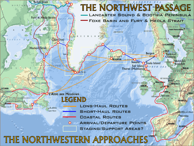
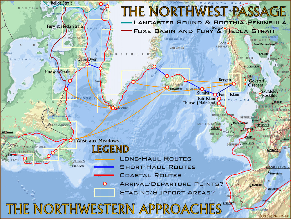
Map 1a. The Northwestern Approaches to the Americas. Larger map (150dpi. jpg)
Achieved an unexpectedly high speed of 7 knots under oars, probably because she rode up out of the water and skimmed along in a semi-planing posture, almost like a power boat. Experiment and theory thus show that in favourable conditions the Viking longship could have achieved high speed under oar or sail, provided that she had a competent crew. (James Graham-Campbell, THE VIKING WORLD, Francis Lincoln, London, 1980:62)

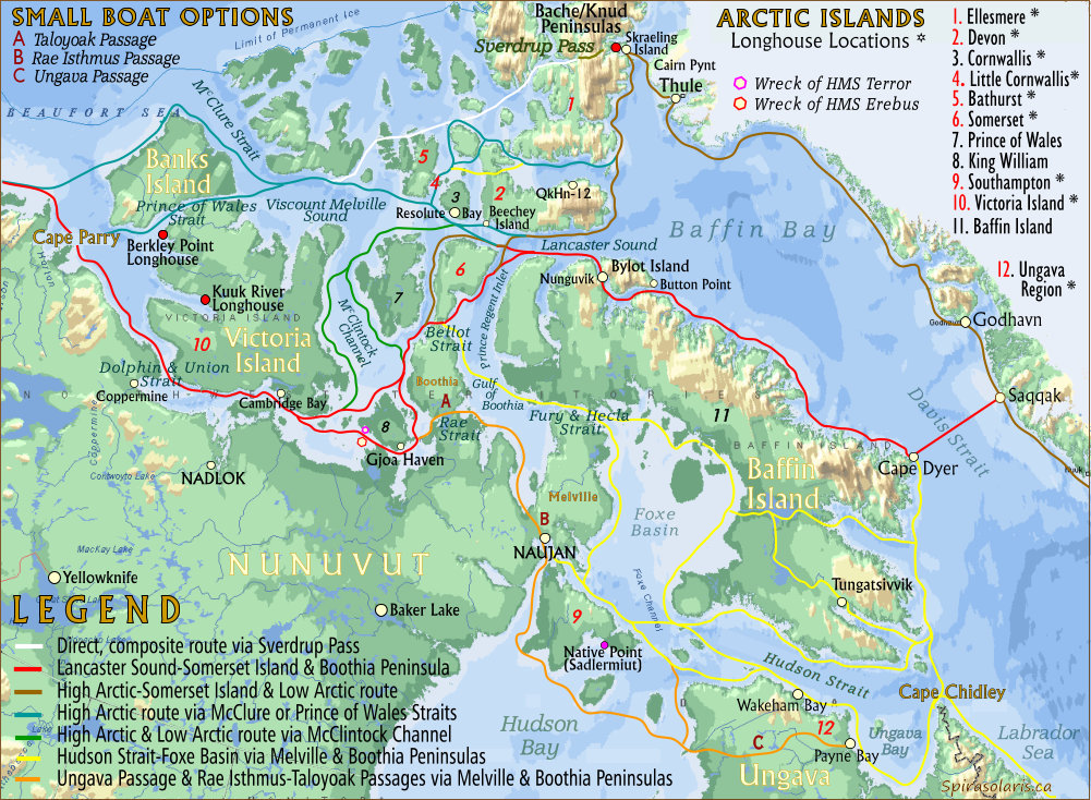
Map 2. The Northwest Passage: High and Low Arctic Routes Larger map (150dpi. jpg)

Map 3. Ice Coverage along the Northwest Passage in Early Summer Larger map (150dpi. jpg)
As the twelfth century ended, the climate reversed. Ice crept southward, all over Europe snow fell lower on the mountain slopes, upland trees died. Pack-ice cluttered the coasts of Greenland, then tightened an Arctic noose to strangle movement.
Nadlok's carbon-dated floors and levels show a 1450-1750 A.D. occupation in the Little Ice Age, a time of deteriorating climate when ocean temperature fell 1-3 deg. C and the Arctic summer front retreated 4-5 deg. of latitude. Sea ice stayed all year in sheltered Bathurst Inlet and east Coronation Gulf, inevitably disrupting sea-mammals and their hunters, but with little effect on caribou.
For the first century or so of their Greenland colonization, the Vikings and their descendants enjoyed a reasonably prosperous and pleasant life there. Greenland's climate c. 1000 A.D. was in an extraordinarily warm phase, and the name Eric chose for his new land may not have been quite the real-estate promoter's con-job as has been assumed. Even 350 years later, after a general global cooling had altered Greenland's climate for the worse, Ivar Bardson wrote that "On the mountains and lower down grow the best of fruits, as big as apples and good to eat. There also grows the best wheat that exists." Life in Greenland was hardly the rough outpost existence we might expect....
However by 1200, climatic change allowed the arctic ice pack to creep farther southward, making navigation in Greenland waters increasingly hazardous -- even in summer. Ships came now only sporadically, and some years none called at all. In 1261, the Greenlanders felt obliged to accept union with Norway and subjection to the Norwegian crown, in return for which two ships would be sent per year. This effectively shut the Hansa markets off from Greenland trade, and sometimes even the promised Norwegian vessels didn't make it through the ice. The colonies' decline accelerated.
Further searches turned up box sections made of oak--a common Scandinavian wood not native to arctic Canada--parts of barrel bottoms, European-style knife blades and spear points, and medieval chain mail. In addition, a piece of woolen cloth found on Skraeling lsland reveals a weave pattern typical of Norse farming settlements in southern Greenland, founded in 986 by Eric the Red. An unlikely trade item for Eskimos, who wore tailored skins and furs exclusively, the cloth may well have reached the island on the back of a Viking. He may not have been the first Norseman to arrive, however. An enigmatic two-inch carving from an early 12th-century house may be a rough portrait of an earlier Viking visitor. Clearly native in style, the carving exhibits features the author believes are distinctly Norse: straight eyes, a straight mouth, a pointed chin, and what looks like a cap. A copper blade taken from the floor of the same house may confirm his hunch. If tests show the metal did not originate in North America, they may indicate that Norsemen encountered Eskimo settlements in the Smith Sound region even before the two peoples came in contact farther south in Greenland. Viking trading and exploration parties had reached Labrador by 1000. But clues of voyages farther north at this time were not discovered until three years ago, when the author began uncovering Norse artifacts in arctic Canada. (Peter Schlederman, "Eskimo and Viking Finds in the High Arctic", National Geographic Magazine, Vol. 159, No. 5, May 1981:578)
People of the Dorset culture held sway over most of the Arctic, from Greenland nearly to the Mackenzie Delta, for roughly 2,000 years, from about 800 B.C. until 1300 A.D.. They figure prominently in the myths and folk memory of contemporary Eskimos. "Tunit" they are called, a race of giants, preternally powerful. "They could haul a walrus across the ice as easily as we pull a seal" Igloolik Eskimos say. But their art is diminutive and delicate, tiny men and masks, bears and birds, some less than an inch in size, carved of bone, stone ivory , or driftwood, and yet usually only an inch or two in size; faces carved in tight groups into bone or ivory measure merely fractions of an inch. (Fred Bruemmer, "The Petroglyphs of Hudson Strati,"The Beaver, Summer 1973:34)
In many ways, the whole Viking endeavor was no more than the active aspect of the Viking belief, a version of their own legends, an extension of the ancient sagas, an attempt to force the undivined future into a shape of their own choosing. Considering this, therefore, one is forced to ask why these vigorous, self-sufficient and often self-satisfied northern communities ever succumbed to Christianity at all. This used to be a simpler question to answer than it is today, for to Christian historians the superiority of their own belief seemed self-evident. Today, with Christianity itself on the wane, one sees the conversion of the Vikings in a quite different way: what on earth possessed them to jettison a religion which had served them so well for a new preaching totally at odds with almost every aspect of their lives? (Peter Brent, THE VIKING SAGA, Tinling, Prescott 1975:148)
La Verendrye's discovery of a runic inscription near the Mandan village can possibly be linked to a second theory about how the tribe acquired its Nordic genetic strain. Eric Thorwaldsson, better known as "The Red," founded two separate colonies of expatriate Icelanders on Greenland's southwest coast in 986. The larger and more southerly, "Eastern," settlement eventually numbered some 3,000 souls (c. 1,100), while the "Western" settlement, 300 miles to the northwest in the region of present day Godthaab, never grew to more then 300-350 population. Lief Ericsson's introduction of Christianity to Greenland in 999 resulted in 16 churches eventually being built throughout the two settlements. The cathedral at Gardar was said to have been a fine edifice; its surviving foundation shows that it was 84' long and 60' wide. The bishop's residence, built after a resident bishop was appointed in 1112 ("Bishop of Greenland and Vinland in partibus infidelum"), was even larger than the cathedral.
By 1340, nearly all of the Western Settlement's 190 farms had been expropriated by the Church in lieu of payments for indulgences, special masses for the departed, etc. The once free and independent Greenlanders were reduced to the status of serfs and tenant farmers on their own former holdings. In 1342 the Western Settlement apparently decided en masse to clear out for parts unknown An ancient account says:
"The inhabitants of Greenland fell voluntarily away from the true faith and the Christian religion, and after having given up all the good manners and true virtues, turned to the people of America ('ad Americae populosse converteunt' ) Some say that Greenland lies away near the western lands of the world."
At the time, Magnus Eriksson, a devout and zealous Christian, was king of Norway and Sweden. In 1347, King Magnus donated a large sum of money the Greenland Cathedral, and was less than enchanted when, a year later, a ship with 17 Greenlanders arrived in Bergen bearing news of the Western Settlement's disappearance.
In 1354 Magnus commissioned Paul Knutson, a judge and member of the Royal Council, to mount an expedition to search for the fugitive Greenlanders and restore them to the true Christian faith. Knutson chose an elite cohort of men, Norse and Swedes, and set sail to the west in a knarr (royal trading vessel). Some speculate that Bishop Gislrikt of Bergen, an Englishman, may have recommended Nicholas of Lynn, an English Franciscan friar famous as an astronomer, to Knutson as a navigator. Surviving members of the Knutson expedition returned to England and Norway in 1363 or 1364 with Ivar Bardson, a priest from Greenland. Nicholas of Lynn presented himself to the kings of England and Norway with a written account of a voyage to the northern seas entitled Inventio Fortunata.
In 1866, remains of a small vessel were reportedly found buried in sand and clay during excavation of a marshy pond in Cedar Rapids, Iowa. According to an eyewitness account, the boat was about 25 feet long with "considerable sheer," and a narrow, wedge-shaped stern with carvings on it. The witness, J.P. Hammond, said that the strongly built and obviously very old boat "agreed closely" with a real Viking boat he had seen on display.
In 1898 Olof Ohman, a Swedish immigrant living near Kensington, Minnesota, uncovered a large, flat stone while pulling tree-stumps on his farm. The "Kensington Stone" is inscribed with runic characters which read:
"8 Goths and 22 Norwegians on exploration journey from Vineland throughout the West. We had camp beside 2 skerries one day's journey north of this stone. We were out fishing one day. After we came home, found 10 men red with blood and dead. A[ve] M[aria], Deliver from evil! Have 10 men by the sea to look after our ship, 14 days journey from this island. Year 1362."
One hypothesis posits that the Knutson party searched in vain for the lost Greenlanders along North America's east coast, eventually entering Hudson Bay. At the mouth of the Nelson River (both the bay and river appear on the Gemma Frisius globe of 1537, 73 years before Henry Hudson sailed the area), a boat party of 30 men left a skeleton crew aboard the knarr and journeyed inland in a rowing boat, proceeding upriver into Lake Winnipeg, then down the Red River into present day Minnesota.
There, 10 of the party were killed and scalped by hostile natives, The survivors, fearing for their own lives, chiseled a message on a large flat stone at an island stopover. Perhaps because of shorthandedness, their boat became wrecked, stranded, or just too heavy to handle, and had to be abandoned.
They eventually make contact with friendly aboriginals. Accepting that without the boat, they have no hope of returning to the waiting ship, the Scandinavians resign themselves to remaining with the Indians. Meanwhile with winter closing in, the waiting men in Hudson Bay reluctantly weigh anchor and return to Norway under command of Nicholas of Lynn. There is no record of Paul Knutson ever returning to Europe, so he may have been with the marooned boat party. Eventually the castaways marry Indian women and teach them the rudiments of Christianity. If this indeed approximates what took place, it would account for the Mandan enigma.
Fundamental
requirements for transiting the
Northwest Passage obviously include ships, maritime competence and
arctic knowhow, and all of these - as far as the Greenland Vikings are
concerned - already appear to be in place. Even so, it would be
difficult, if not almost impossible to proceed clear through the
Passage in a single summer, although a warmer climate would obviously
be beneficial even if it did not permit a single-season passage. Then
again, who is to know how far they might have been able to travel in
three or four months, or indeed whether they could have used the
shorter High Arctic routes if they were indeed open in their day.
Taking the conservative approach, however, it is likely that at least
one winter would have to be spent in the Central Arctic, perhaps at a
location roughly half way or other locations depending on the route
chosen. Either way it would
not be the daunting prospect it might seem; the Vikings had after all
wintered
in settlements further north along the west coast of Greenland thus it
would
not be a new experience for them.
The exact route they may have
taken is not
immediately apparent, but nor is it our primary concern. Either way
after wintering-over and preparing for the next leg after entering the
Beaufort Sea there would still be many more difficult miles ahead.
First they would need to proceed along the Yukon coast, then past the
Alaskan North Slope and south past Seward Peninsula. Continuing south
and then west again along the Aleutian Islands they would eventually be
able to swing south through Uminak Pass to finally reach the Pacific
Northwestern regions of North America. Was this their heading and their
destination? It is suggested that it was, at least initially, but
before getting to the precise locations additional groundwork is
required.
SUGGESTIONS OF A VIKING PRESENCE IN THE ARCTIC
The household furniture consists of stone kettles or pots, and wooden troughs of various sizes, with dishes, scoops and spoons made of musk-ox horns. The pots are carved of a pepper-and-salt stone which appears to be very porous, but us nevertheless perfectly tight and will sound as clear a note as a china bowl. Some of these pots are large enough to contain five or six gallons. It is impossible that these poor people can perform this arduous work with anything other than harder stones as tools, yet these kettles are far superior to any I ever saw on Hudson's Bay, every one being ornamented with neat mouldings around the rim, and some of the large ones with a kind of flute-work at the corners. In shapes they are a long square, somewhat wider at the top than at the bottom. Strong handles of stone are left at each end to lift them up. (Farley Mowat, Coppermine Journey, McClelland & Stewart, Toronto, 1958:103; emphases supplied)It seems likely that the material used to make these utensils was soapstone, but although the sizes and the ornamentation appear to be unusual, this hardly proves that they were Norse in origin. Nevertheless, the question that now comes into focus is just what would be indicated if the Vikings had indeed made their way thorough the Canadian Arctic Archipelago.
It was originally held that not a single shred of hard of evidence for a Norse presence in North America existed. This view was modified by Helge Ingstad's discovery of a small Viking settlement at L'Anse aux Meadows in Newfoundland in the 1960's, but it was still a limited eastern indicator and the northern route West has remained pre-empted by Matthiassen's Thule-Alaskans. However, in an article in the magazine INUKTITUT (Spring 1987) Father Guy Mary-Rousseliere published some of his own findings at the Dorset/Thule site at Nunguvik on northeastern Baffin Island, a site previously examined by Matthiassen in 1923. Among Father Guy Mary-Rousseliere's findings at Nunguvik were models of skis (for photographs see the Nunguvik link):
Other wooden artifacts include frame parts of a small kayak model, the front part of a full-size sled runner with holes and grooves for lashing the shoeing (many pieces of sled shoeing of baleen, ivory and antler have also been found) a complete model of a ski (pointed and curved at both ends like old Lapp and Siberian types) and parts of three similar models...Skis were previously thought to have been introduced into Canada from Europe (Father Guy Mary-Rousseliere, INUKTITUT, Spring 1987; emphases supplied)In addition, Peter Schlederman's more recent research at Skraeling Island also suggests something quite different. There are indeed indications of a Norse presence in the High Arctic, as the latter explains in amplification of an earlier Viking find:
It has been three years now since that piece of rusted armour came to light. Two members of our 1980 team, Peter Francis and Carol Franchette, located additional Norse artifacts including boat rivets and knife blades. The Thule houses have also yielded an oak box section, parts of bottoms of wooden barrels, and numerous iron and copper pieces. One of the most revealing finds was a piece of woolen cloth whose date was established by radiocarbon tests at about A.D.1250. Hoping for identification of the cloth, I took it to Else Østergaard of the National Museum staff at Brede in Denmark, my native country. After careful analysis, she pronounced the cloth definitely Norse in origin and the type of weave common to the Viking colony in southwest Greenland. (Schlederman 1981:600)
In 1978, prior to our work on Skraeling Island, we had begun to excavate one of the most exciting ruins Tore and I had located in our original survey.. It was the stone foundation and part of the walls of a late-period Dorset longhouse situated near the shore of Knud Peninsula just south of the Bach Peninsula. The house was an immense structure even by present standards, measuring 5 meters in width by 45 meters in length (16 by 148 feet). It was not a house in the sense of an enclosed building, but a framework of waist-high walls built of boulders. I believe it served as the foundation for a row of skin tents such as the Dorset people doubtless used. One of the most striking features of the site was a long row of outdoor hearths located some distance from the house and extending 32 meters from end to end. The row contained 18 individual hearths, each one separated from its neighbor by a stone platform undoubtedly used for temporary storage of food. This multiple arrangement of outdoor hearths is unique; nothing like it has ever been identified among prehistoric living sites in North America.Unique it may be, but it is certainly understandable in terms of Viking incursions and provisioning needs, and because of its size and unique structure, far less understandable if restricted to Inuit activities alone. (for a further alternative hypothesis, see also Gavin Menzies, 1421:The Year China Discovered the World, Bantam, Toronto, 2002:299-302).
Almost every little hollow or more-or-less-level bit of ground on the island seems to have its stone tent ring, some of them 20 feet in diameter. There are also numerous depressions Lee said were the remains of semi-subterranean winter houses of ancient pre-Eskimo cultures. Near the east end of the island we came to three cairns, cylindrical and about six feet high. They don't look anything like the Eskimo inuksuit [stone markers] I've seen all over the Arctic. I made the point to Lee and he agreed: "Yes, too big. Too regular. Too well made. Not Eskimoan at all."However, the main thesis proposed by Farley Mowat in The Farfarers differs markedly from this viewpoint, for as he explains in the introduction (1999:xv), the thesis itself grew out of a "conviction that the Norse were not, after all, the first Europeans to cross the Western Ocean". Although the latter - the "Albans"- become The Farfarers, Farley Mowat nevertheless still provides an excellent summary of the Norse viewpoint suggested by Thomas Lee's researches in the Canadian Arctic. Thus he continues:
We trudged back along the south shore. The tide had fallen so far that the sea was only distantly visible across a vast, glistening plain of jumbled rocks, boulders and mud. Lee pointed out a sort of broad pathway or ramp running seaward from the high-tide line. Somebody had put in a hell of a lot of work clearing it of the worst of its jagged rocks. Again Lee ruled out natives: "No Eskimo would go to that much trouble to make a boat landing. They wouldn't need to for kayaks and canoes. I think this must have been a haul-out for big boats."
Lee trotted me into a bit of shelter behind a ridge of frost-shattered rock, to the site he was digging. Not very impressive. A muddy rectangle about 45 feet long by maybe 15 wide, with turf, moss and stones stripped away to a depth of a few inches, at which point the diggers had hit bedrock. I could just make out the remains of some low stone walls. Lee waited about 10 seconds for questions, then beat me to the punch. This is some sort of longhouse. Not the kind the Six Nations and other Indians built in the south, but its own kind. There are three like it on Pamiok -- two this size and one much larger. The Eskimos say there're several more to the north. Nothing like them has ever before been described in Canadian archeology. "I've traced the outline of this one. See, it's somewhat boat-shaped, with slightly curved sides and rounded ends. The walls were of stone and turf and low -- four feet at most. I've found little in the way of artifacts except a lot of Dorset-culture litharge [scraps and flakes of flint], much of it on top of rotted turf from fallen walls. Dorsets [a pre-Eskimoan culture] seem to have camped here after this longhouse was abandoned."
He led me up an easy slope and I almost stumbled over the ruin before I saw it. Boulders, tumbled every which way, blended so well with the mess of other rocks, it needed to be pointed out to me. Then I could make out the shape of what looked like a tomb for Gargantua. It was at least 80 feet long, maybe 20 wide, and bloody massive! In some places the walls still stood three feet high but were mostly broken down, with their boulders rolled into the central space. I say boulders because that's what a lot of them were. Lee guessed some weighed more than a thousand pounds. All were coated with a layer of lichens that must have taken hundreds of years to grow. Looking across this enormous jumble, Lee summed up his thoughts: "Difficult to believe this was built by Eskimoan people. What earthly reason would they have had? Eskimos may have sometimes pitched their tents inside these longhouses, and Dorset and Thule-culture [paleoEskimos] probably did the same. But I doubt any of them built these longhouses." "Then who did?" He smiled quizzically. "Well, now, Mr. Mowat, I suppose that's for me to find and you to ask. At this stage a cautious professional wouldn't say. But I don't think you'll be surprised if I predict they'll turn out to be Europeans. Possibly Norse." (Farley Mowat, The FarFarers, Seal Books, Toronto, 1999:6-11, emphases supplied)
In the years ahead, Lee and I became friends, exchanging findings and opinions. He supplied me with copies of his meticulously detailed archeological reports. I gave him the results of my research into early Norse history. In 1967 he went back to Ungava and found an even larger longhouse on another island a few miles north of the Payne. He then returned to Pamiok and began an intensive investigation of the big house there. This dig required three seasons to complete and yielded remarkably little enlightenment in view of the enormous amount of time and energy Lee expended on it. Nothing emerged to satisfactorily explain its purpose or identify its builders. It remained an enigma, beset with mysteries.Farley Mowat's proposed solution to this enigma turns out to be a very neat, highly functional way of wintering-over in the Arctic regions. In short, the latter suggests that the roofs in question were essentially the inverted boats of the Farfarers, thus he states:
One of these was how the Pamiok big house or, indeed, any of these Arctic longhouses, could have been roofed. Lee's excavations (together with those undertaken in later years by other archeologists on similar sites) have failed to produce evidence of roof supports, whether of wood or of such possible substitutes as whale bones. Furthermore, the nearest timber suitable for roof construction at the time they were built was at least 120 miles to the southward of Pamiok, and 1,500 miles to the south of a group of similar longhouses found in the 1970s on the shores of Kane Basin in the High Arctic.
The roof question has bedeviled every archeologist who has investigated it. Some have concluded the longhouses weren't "houses" at all and so need never have been roofed. But, if not houses, what were they? The orthodox opinion seems to be that they served some kind of ceremonial or religious purpose; but there is no evidence to buttress such a hypothesis and the distribution of the sites makes such an explanation inherently improbable. Lee suspected the structures were temporary shelters built by Norse voyagers visiting the region around A.D. 1000. Indeed, ground plans of Norse croft houses of that period in Iceland, the northern British Isles, and parts of Scandinavia resemble these Canadian Arctic longhouses. All are long and narrow, often with slightly curved side walls. Proportions and dimensions are generally comparable. There the resemblance ends. Norse (including Icelandic) longhouses were invariably roofed, with sod, turf, bark or thatch supported upon robust wooden frameworks which have, almost without exception, left archeologically identifiable traces. A number of years were to pass following my visit to Pamiok Island before the Arctic longhouses began revealing their mysteries to me. They first did so on the far side of the Atlantic Ocean. (Farley Mowat, The FarFarers, Seal Books, Toronto,1999:11-12, emphases supplied)
As many explorers would discover the hard and sometimes fatal way, surviving the harshly inimical Arctic winter is no easy matter. Food and shelter are the prim requisites. Food can be found by those who know where and how to look, but finding shelter may be something else. Aboriginal Arctic dwellers solved that problem with the snow house. Valuta seekers found their solution in boat-roofed houses, a construction which had been traditional with them for centuries past. Their own vessels, upturned on foundation walls built of stones and tightly clinked with moss or sod, could protect them from the most extreme winter weather. (Farley Mowat, The FarFarers, Seal Books, Toronto,1999:187, emphases supplied)The latter also notes further that:
It is no accident that the largest assemblage of boatroofed house foundations in the high north is concentrated around polynyas. Most are in the Smith Sound region, the remainder being adjacent to polynyas as far south and west as Devon, Little Cornwallis, Bathurst, and Somerset islands.All of which can be seen from at least two external perspectives - certainly the Farfarer scenarios proposed by Farley Mowat, but also that of Norse incursions deep into the Arctic Archipelago, and even perhaps through the Northwest Passage when the implications of the site on the west coast of Victoria Island are taken into consideration. Moreover, it is not difficult to see that both the upper and lower entrances to the Northwest Passage are also involved (if not directly indicated) as shown in Map 2 above.
One striking exception exists near the mouth of the Kuuk River on the west coast of Victoria Island. Slightly over one hundred feet long, this low-walled structure discovered by Dr. Robert McGhee, head of the scientific section of the Archaeological Survey of Canada, stands alone on a desolate stretch of stony beach. Of the right dimensions to have supported two vessels overturned end to end, it may have been built by farfarers seeking an unclaimed polynya or forced far to the west by adverse ice conditions. On the other hand, McGhee has pointed out that the Kuuk River leads to a glacial deposit of native copper known to have been exploited by the Inuit, which could have been a source of copper for valuta seekers too. Probably because of its isolation, the Kuuk River example is the best preserved of the forty-five boat-roofed foundations so far described or excavated. Most of the others have been quarried by natives for stones with which to build tent circles, meat caches, and shelters. Thule-culture people, impelled by a powerful animosity towards the original builders, may even have deliberately destroyed some of the foundations by systematically tumbling their walls. However, more than enough remain to provide a good idea of what the structures must once have looked like, of how they were built, and of how they functioned. Although varying from about thirty to a hundred feet, the majority are of the order of fifty feet in length. Except for those few designed to support two, or even three, ships set end to end, they have an average length-to-width ratio of 3.5 to1, roughly the same as that of north European working ships from circa A.D. 1000. Walls were built only high enough to accommodate the curving shee of the covering vessel and to provide internal headroom. Few seem to have been even as much as four feet in height. Since there is little soil or sod in the high Arctic, foundations were constructed entirely of stones (sometimes very large ones) chinked with moss and lichens. In the subarctic they were generally built of sods ballasted with stones. Turf and sods reinforced with wood provided building materials south of timber line--a combination that time has reduced to almost invisible mounds. Most were sited close to the high-tide and storm line. In several instances, rocks fouling a landing beach seem to have been cleared away to protect fragile vessels from damage when they were hauled ashore. Once emptied of gear, ballast, and supplies, a fifty-foot skin boat would have been light enough to be manhandled to a mating with a prepared foundation. Larger vessels may have been moved on rollers, then overturned and eased into position using their own spars as levers.
There seems to have been only one (necessarily low) door, located in a side wall. There were no window openings, but well-oiled sea mammal skins are remarkably translucent. During the long winter night, the houses would have been lighted and, in the high Arctic, perhaps heated (Inuit style) by lamps fuelled with sea-mammal oil. Farther south, where wood was available for fuel, smoke could have presented something of a problem. But it would have been no trick to cut a smoke-flap in the "roof,' an aperture that could have been easily patched before the vessel again took to the water.
Heating the entire interior of a large boat-roofed house would have been difficult. However, heatable cubicles could have been fashioned using animal skins (preferably caribou) for ceilings and curtain walls. This is a system I have myself used to good effect in the barrenlands of Keewatin. Boat-roofed houses would have provided spacious, comfortable accommodations for the times when they were being built and used. They would also have ensured the best possible protection, from weather and from hungry animals, for the vessels themselves during the long winter months. (Farley Mowat, The FarFarers, Seal Books, Toronto,1999:189-191, emphases supplied)
But the Farfarers
were earlier than the
Vikings, at least according to the time scales allotted to the Sagas,
i.e., around the end of the First Millennium. Then again, however, the
dates of the Oseberg and Gokstad burial ships - ca. 800 and 850 A.D.
respectively - indicate that in technical terms at least, the Norse
already had ships up to the task, and even these dates do not rule out
the possibility of earlier excursions. Interestingly enough, the design
of these earlier vessels may shed some
light on the inverted hull/roof scenario. Inverting canoes for cover on
shore, etc. has origins that probably extend back to the earliest forms
of
river
transportation. When applied to larger craft, however, size, weight and
construction also enter into the equation, as does the size of the
crew.
In the case of the Tune, Oseberg and Gokstad ships, however, there were
no fixed rowing benches. The usual and most probable explanation given
for
this is that the crew used their own sea-chests--a theory supported by
the
fact that sea-chests found in the Oseberg ship were exactly the right
height
for this purpose. There are undoubtedly distinct advantages in not
having
fixed rowing benches incorporated into the design. Firstly, there is
the
saving in total weight; secondly, the removal of such chests along with
their
contents would be beneficial when such ships are brought ashore and/or
maneuvered
on land. Lastly, if the practice of inverting hulls is also a design
consideration,
then valuable head-room would also be gained by eliminating built-in
benches
altogether. This, of course, brings us back to the stone longhouses in
the
Arctic Regions, where adequate quarters and shelter from the elements
would
have been of paramount importance for the Greenland Vikings hoping to
survive
the long arctic winters, be it on Greenland, Ellesmere Island, Ungava
or
even further west.
Lastly, it is generally agreed
that the Oseberg
and Gokstad ships were masterpieces of design that combined beauty with
functionality; what also might be added here is that such
ships--ideally,
perhaps a 40 or 50-foot variant of the Gokstad design with a determined
crew, or as we shall see later, some of the Skuldelev/Roskilde
designs--could
have gone just about anywhere on Earth.
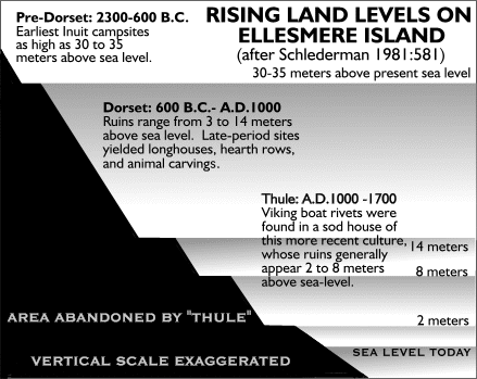
the sea-level in the Arctic was also quite different from that of the present day, as seen from the following data for Ellesmere Island: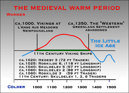
Fig. 2. The Medieval Warm Period, Little Ice Age and the Vikings
Fig. 3. Rising Land Levels on Ellesmere Island, 2300 BCE to 1700 CE
... were near the sea on a beach. Since then, the land has risen, and today the houses are over twelve metres above the sea's level and one hundred metres from its edge. The ancient occupants of these shelters are known as the Thule (pronounced Too-lee) people. Ancestors of the modern Inuit, they had migrated eastward across the Canadian Arctic from Alaska about 1000 years ago. They settled at Naujan around A.D.1200, and were hunters of the great bowhead whales. (source: Naujan: Repulse Bay )To which may also be added my own observation in the late 1980's of stone tent circles near raised beaches on Jenny Lind Island even further west along the lower reaches of the Northwest Passage. Here the beaches in question were again higher and at least half a mile from the current shoreline.
PETROGLYPHS AND
STONE CAIRNS
But are there any indicators to support the
suggestion that the Northwest Passage itself may have been conquered in
earlier times? Particularly intriguing in this last context are
unexplained stone cairns in the Pacific Northwest reported by Frederica
de Laguna (1971:82) in her amplified edition of George Thornton Emmons'
The Tlingit Indians, which also contains a relevant point
concerning Pacific Northwest petroglyphs:
Most permanent but least intelligible of all of the earlier works of the Tlingit are the petroglyphs which are of frequent occurrence on the shore in the vicinity of old living sites, throughout the inland waters of southeastern Alaska. The present generation, even the oldest natives, have no knowledge of their origin or use, and even deny that they are the work of their ancestors, attributing them to a stranger people who preceded them and left such signs to mark their movements or to guide others who might follow.(Frederica de Laguna, George Thornton Emmons' The Tlingit Indians, 1991:178, emphases supplied)As far as North American petroglyphs are concerned, it is necessary to make two things clear from the outset. Firstly, there are many, many petroglyphs on this continent and it is recognized that the overwhelming majority of them are indigenous. Furthermore, even those that might be considered to have possible Norse connotations may still be relatively few in number. Nevertheless, it is still possible to suggest that certain symbols above all others may be applicable in this context - especially the "spiral", the "sunburst", and what are often termed "Spirit Faces." And even here the vast majority, although perhaps relatable, may nevertheless still be native in origin, form and continuity. Nor, in any case, do such symbols originate with the Norse since they are almost global in their distribution and also far older.
THE STONE CAIRNS
Returning to the unexplained stone cairns, Frederica
de Laguna adds her own observations on the subject to those of George
Thornton Emmons as follows:
More baffling than petroglyphs and stone carvings are cairns of piled stones to be found on the mountains well above timberline, both on the mainland and on offshore islands. They have no relation to the Russian occupation, and are not boundary marks. They are away from any trails or lines of travel, at altitudes of from two to three thousand feet, located on clear stretches, generally on mountain tops. The oldest natives can give no explanation of them, beyond the story that when the great Flood covered the earth, those who survived in canoes floated up and moored their craft here with great bark ropes, the decayed ends of which it is claimed can still be seen. [Cairns like these were said by the Tlingit of Angoon and Yakutat to be "nests" or forts made by survivors of the Flood to protect themselves from the bears that were driven to the summits of mountains by the rising waters (de Laguna and McClellan, field notes, 1950, 1952). Stone piles have been noted by some members of the U.S. Geological Survey, who offered no explanation for them. My archaeological party of 1935 explored a pile of stones on a high ridge above the middle Yukon River, between Nulato and Holy Cross; this "cairn" was due to frost action, according to our geologist, Jack Eardley. But this explanation may not apply to all such piles.] The following locations of such cairns are known, others may still be discovered: On a mountain 2,500 feet high, above Union Bay and Ernest Sound, on Cleveland Peninsula, there are four or five pyramidal or circular piles of stones. Watson, half-breed, knows about this. On a mountain on Etolin Island is a cairn of boulders. At Gambler Bay, on Admiralty Island, on a mountain about 2,000 feet high, there are five piled stone monuments, three to four feet high: one is about eight feet long, one somewhat in the shape of a J, two are pyramidal, and one is oblong. Cook of Juneau, a prospector, knows about two piles of stone, J-shaped and pyramidal, on a mountain about 2,500 feet high, above Pybus Bay, Admiralty Island. [These may possibly be some of those reported back of Gambler Bay.] On the mountains on the eastern shore of Lynn Canal, some thirty miles from tidewater, following the valley of the "Katzheen river" [Katzehin River, "Tabooed River"], and overlooking the glacier from which the river flows, are two pyramidal cairns, carefully constructed of slate, for the most part. This was evidently for durability, since the rock in the immediate vicinity is softer sandstone. These cairns are some four hundred feet apart, bearing north and south from each other. They are respectively 3 ½ and 4 ½ feet high, and 3 ½ feet wide at the base, and taper to a point. While these cairns are known to the Chilkat, the latter have no knowledge of their origin or use, except that they are similar to others found on islands to the southward which certainly had no connection with the Russian occupation. These cairns above Lynn Canal might be considered as boundary monuments to define the inland limit of Russian territory, since they are thirty miles inland, which marked the extent of the coastal strip of southeastern Alaska claimed by the Russians. On the Chilkat divide, near the summit of the coastal mountains, overlooking Rainy Hollow, and about ten marine leagues [about forty-four statute miles on a direct line] from tidewater, is what the natives term, "Stone House." This is just beyond the summit, on a level, moss-covered plain, free from any obstructions, and visible for all directions. It originally consisted of three great slabs of granite placed on end, and inclined toward one another to form a pyramid. One of these in time has disintegrated, as is attested by the broken pieces at the base. The two remaining stones still support each other. They are 5 feet high, 4 inches thick, and respectively 4 and 6 ½ feet wide at the base. Such unwieldy stones must have been transported at great labor from an old streambed several hundred feet distant. This must have been the work of a party of Russians who visited the Chilkat in 1838 and placed such a monument to mark the boundary of southeastern Alaska ["Russian America"], preparatory to leasing the littoral to the Hudson's Bay Company in 1840. This is the belief of the Chilkat people, as attested by the affidavits of some eighteen of the older Tlingit of Klukwan which I took in 1902 when acting as Boundary Commissioner under the Secretary of State. From the character of this monument it does not seem to be related in any way to the piled rock cairns found at other places. [Just what Emmons found, or did not find, is a puzzle. No "boundary marker" or "stone house" was mentioned in the testimony published by the Boundary Tribunal. What Emmons described may have been an emergency shelter built by natives (or white prospectors?) for anyone caught in a storm on the pass. Shelters in the cracks of "a loose mass of huge boulders piled over each other" on the Chilkoot Pass were called by the Tlingit "stone houses," but Schwatka (1893:81) did not indicate whether these were man-made or natural piles. Also not mentioned in the testimony to the Boundary Tribunal, as well as in Emmons's notebook, were the half-dozen postlike stones, about three feet high (?), set in a line (or lines)--an arrangement that would suggest "boundary markers." Were they set by the Tlingit to define the "boundary" beyond which Athabaskan traders might not come? Or were they "scarecrows," built in connection with a caribou fence? (The Tlingit Indians, by George Thornton Emmons. Edited by Frederica de Laguna with additions and a biography by Jean Low, Douglas & McIntyre, Vancouver 1991:82; emphases supplied)Signs of Viking presence? Difficult to say, of course, but someone must have built these cairns and whoever did must also have had the need and ability to include forays among the major islands off south-eastern Alaska into the bargain.

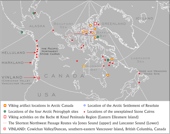
Map 6d. The Unexplained Pacific Northwest Cairns and Routes South

What do stone cairns have to do with the possible presence of Vikings in North America? Potentially a great deal. For a start, there are two stone cairns in the vicinity of the Viking settlement at L'Anse aux Meadows in Newfoundland (Robert McGhee, "The Vikings. They got here first, but why didn't they stay?" Canadian Geographic, Vol.108, No.4. Aug/Sept 1988:18). Originally there were also two more in Newfoundland to the south at Saint Georges Bay originally attributed to Captain James Cook, but as Farley Mowat's research indicates, there appears to be no mention of them in the latter's records (Mowat 1999:424-425). Moreover, there are also stone cairns in New England (see the New England Antiquities Research Association photographs under "Rock Stacks and Mounds," e.g., the sloped cairn near Madison, CT) and others near Allentown, Pennsylvania and Red Wing, Minnesota (see Map 4 and the main text). To which might also be added the stone cairn and tablet discovered by La Verendrye on the banks of the Missouri River in North Dakota (see: The Mystery of the Mandans, by Charles W. Moore). Furthermore, there are stone cairns (not to be confused with Inuit inukshuks) found at strategic locations along the Northwest Passage itself - one near Cape Dorset on the southwest corner of Baffin Island, two more in the Central Arctic on King William Island and O'Reilly Islands respectively, another near Komakuk Beach close to the Yukon-Alaska border and yet another inland at Angikuni Lake in the Canadian Barrens (Farley Mowat, Coppermine Journey, McClelland & Stewart, Toronto, 1958:9). Then there are the stone cairns of the Ungava Region of Northern Quebec initially encountered by Farley Mowat during a fog-bound canoe trip off the west coast of Ungava Bay in the company of Zachareesi, a local Inuit guide:
The murk became thicker as Zachareesi fish-tailed his canoe through a swirling maelstrom of currents pouring past, and over, unseen rocks. He was "smelling his way" toward the northern headland of the estuary. Suddenly he shouted and pointed to the left. Wavering in the gloom was a dim shape. The fog swirled away, revealing a stone tower nearly twice the height of a man. Smiling broadly, Zachareesi announced we had reached Tuvalik Point at the mouth of the river and were free of the tormented waters of the estuary. We went ashore for a smoke. I examined the structure with great interest, and some affection, for it had served us well. It was constructed of flat stones carefully fitted together without mortar to form a cylinder nearly five feet in diameter. It had evidently once stood 12 or more feet high, but had lost a number of upper-level stones, which were scattered around the tower's base. Notably, the undersides of these fallen stones lacked the thick, crusty coating of age-old lichens which clothed the undisturbed surface of the tower. I asked Zachareesi who had built this useful beacon and when. He grinned and waved his stubby pipe-stem to the north. "Old-time people. Not Inuit anyhow." (Farley Mowat, The FarFarers, Seal Books, Toronto, 1999:4-5, emphases supplied).
"I speculated on just what the structures were. There was a group of archeologists from the U. of Quebec working on a Dorset Eskimo site within about half a kilometer of the structures. When I asked them, they couldn't tell me very much, and it didn't seem that they were interested. They were there to do their Dorset dig, nothing more.
But I've often thought about the structures. They may have been Dorset, but if they were the archeologists would surely have shown more interest. They were certainly most unlike the Inukshuks of the modern Inuit. Could they have been European? They were orientated more or less east-west and at a right angle to the entrance to Diana Bay, and to anyone coming out of Hudson Strait from the east and around Cape Hopes Advance, they might have appeared as fingers suggesting either welcome or danger. Perhaps 19th Century whalers?" (Ed. Weick, Light Stuff, 2003; photographs from the 1970s; emphases supplied)

Early in the summer of 1948 Jacques Rousseau, chief archaeologist of Canada's National Museum accompanied by a young French anthropologist named Jean Michéa, set out to cross Ungava peninsula from west to east. The four-hundred-mile canoe journey would take them up to the Kogaluk River from Povungnituk Bay to Payne Lake, then down the Payne River to Ungava Bay. The route was unmapped and, according to Father Steinman, the priest in charge when I visited the Oblate Mission at Povungnituk in the 1960s, had not previously been traveled by white men. "Not in our time, anyway;' he told me, "though the Inuit say it's a well-marked road. Many cairns along the way. Big ones; not inuksuak. The old people say they were built by kablunait--white men--before the Inuit came into the country I can show you a picture of one on the coast not far from here. It used to have a twin, but a couple of years ago prospectors pulled it down to see if there was a message in it. The remaining twin stood (and I hope still does) on Cape Anderson, the northern point of Povungnituk Bay. A massive cylinder about ten feet tall and more than four in diameter, it is artfully laid up of flat stones, some of which must weigh three or four hundred pounds. Steinman told me there were more like it in the island labyrinth at the mouth of the Kogaluk River. Accompanied by an Inuk guide, Rousseau's party set off from Povungnituk in a twenty-two-foot freight canoe. They noted the beacons in the mouth of the Kogaluk, and thereafter, at almost every point along the way where they might have gone astray, encountered what Rousseau described as "symmetrical and well-made cairns." At the height of land separating the two watersheds, they entered a maze of lakes and streams in which they could have wandered for days had not the vital connecting portage been marked by a stone pillar visible several miles away. Four days later the travellers were in Payne Lake.Lastly, one other point of interest that remains is the route across the Ungava Peninsula to Hudson Bay via Payne Lake shown on Maps 2, 2a and 4:
The eastern end of this eighty-mile-long body of water constricts to form a narrows a few hundred feet wide and a mile long. Here the guide nosed the big canoe to the north shore. This, he told the white men, was the great crossing place of tuktu--the caribou. Indeed, the foreshore and the slope leading down to it had been so trampled by uncountable hooves as to have become almost as level as a highway. Beginning in late summer, the Ungava caribou herds come drifting south, only to be deflected eastward by the barrier of water. By the time they reach the Payne Lake narrows, innumerable small herds will have coalesced into an aggregation so vast that, after the animals have swum across, the shores for miles downstream will be whitened with a yard-wide fringe of shed hair. Biologists estimate that as many as 100,000 caribou funnel through this defile annually. The guides ancestors, so he said, had always wintered here in order to take advantage of the caribou bounty. Rousseau and Michea found the stony tundra along the north shore so heavily pocked with tent circles and house pits it had a lunar look. Moss-filled depressions were all that remained visible of semi-subterranean houses made of turf and stones. Michea counted twenty-two of these, and later surveys have added at least thirty more. Even if all were never occupied at the same time, the land overlooking the narrows must, from time to time, have been the site of a virtual metropolis in what was otherwise a sparsely populated tundra world.
Exploratory excavations by Michea and Rousseau uncovered masses of caribou bones, and revealed that some of the people who had lived here during a succession of occupations had belonged to the Dorset cultures. This was, in fact, the first Dorset site ever to be found any distance inland from a salt-water coast. A few days later the little party continued on its way. They slipped swiftly down the Payne past two more tower beacons, then, near the river's mouth, came upon one of the most extraordinary monuments in the Canadian North. It is a stela, or standing stone, almost nine feet tall, weighing in the neighbourhood of two tons. Upon the top is balanced a stone cross-bar more than four feet long. The bar in turn is surmounted by a granite block roughly fourteen inches square, set slightly off centre. The visual impact of this misshapen cross is stunning--if massively enigmatic. Standing on the floor of the valley, it cannot be seen from any great distance; but if one happened to be ascending the river in search of a Christian community supposed to be somewhere in the vicinity, it would unequivocally direct the searcher upriver and to the first of the beacons pointing the way to Payne Lake.
Rousseau never forgot the cross, or the Deer's Way. He was convinced that something of great historical significance was waiting to be uncovered hereabouts--something that did not fit into the seamless sequence of pre-Dorset, Dorset, Thule, and Inuit occupations of the Canadian Arctic that most professional archaeologists then espoused and, in fact, still do. In 1957, shortly after becoming director of the human history branch of the National Museum, Rousseau sent a new employee, William Taylor, north to investigate the sites.
Taylor flew to Payne Lake, where he spent a month digging up Dorset, Thule, and Inuit artefacts. He also made some findings that, he would later tell me, "smelled of a European presence? Although usually meticulous about reporting on his field work, Taylor never did publish a full account of the Payne Lake "dig." When, many years later, I asked him why, he replied in forthright style that any suggestion of a European component in a pre-Columbian Arctic site would have "given the high priests of the profession cormiptions .... I was a new boy in the field, so who was I to rock the boat? Besides which, I didn't have any hard evidence. At the urging of the Hudson's Bay Company manager at Payne River Post, Taylor also visited Pamiok Island at the mouth of the Payne estuary There he was shown what he described as an immense, stone-built foundation unlike anything previously reported from the North American Arctic. Taylor turned a few sods but left the island the same day. He never did return to excavate this extraordinary anomaly. But the ambivalence of his attitude towards it showed in the Inuit name he gave the site: Imaha--which translates as "maybe" 'Maybe what?' I asked him when we discussed the find. He smiled. 'A good scientist slams no doors. Maybe some day somebody will come up with proof there was a bona fide Norseman on Pamiok in days of yore. If so, I won't be struck all of a heap, as the Limeys say '
I reminded him that archaeologist Tom Lee had found human skulls associated with the longhouse structures on Pamiok; one of them, according to physical anthropologist Dr. Carleton S. Coon of Harvard University, "probably European" and another "predominantly, if not fully European:' Lee had also found a corroded iron axe head typical of the kind used in tenth-century northern Europe. Metallurgic analysis by Canada's Department of Energy, Mines, and Resources established that its composition and mode of manufacture were consistent with that period and place. There was also the presence in the vicinity of Pamiok (and of most other subsequently discovered Ungava Bay longhouses) of stone-built shelters designed to provide nesting places for eider ducks and so facilitate the collection of their down. Such shelters have been employed since ancient times in Europe's northern islands, and are still in use in Iceland. There is, however, no evidence to show that North American native peoples ever constructed such devices. They are considered to be strictly a European artefact. Taylor nodded as I went through the list. "It's evidence, certainly, but it ain't proof, Farley, Imaha! But don't expect me to come out with a Norse helmet on my head."
In 1967 Dr. William Taylor became director of Canada's National Museum of Man, a post he held (as director, then as director emeritus) until 1994, when he died, full of honours and distinctions.
(Farley Mowat, The FarFarers, Seal Books, Toronto, 1999:267-273, emphases supplied)
Map 2a. The Stone Beacons and Longhouses in the Ungava Region (after Mowat, 1999)
which brings to mind the possibility that other short cuts across the Canadian North may have been attempted. Perhaps from the western side of Hudson Bay through the Barren Grounds to the Back River, for example, or into Queen Maude Gulf, or even as far afield as Nadlok and Bathurst Inlet - the most lengthy and difficult perhaps, but also the most useful, completely by-passing both Fury and Hecla and Bellot Straits. Then again, there is also the short cut across Boothia Peninsula just to the north of Spence Bay (Taloyoak) - a convenient passage evident today via satellite imaging (see Figure 6, "Using Landsat to Update Canada's Arctic Nautical Charts," by G. Tomlins, P. Wainright and M. Woods in Lighthouse, The Journal of the Canadian Hydrographic Association, Ed. 52, Fall 1995:31-39). This short-cut was in fact used in conjunction with two additional passages by Martin Leonard III during a recent epic kayak trip across the arctic coast of North America that:
... utilized three significant traditional portages: Itibliyaruk on the Kent Peninsula, Taloyoak portage across the Boothia Peninsula and the Rae Isthmus route. In over 2,400 miles of travel, paddlers needed to carry their craft for a total of only three miles-less than one percent of the route. (Spinnaker Wyss-Johnsen."Paddling the 'Inuit Passage,' " SEAKAYAKER, Vol.15, No.3, August 1998)For additional details concerning this remarkable trip see "Tradition and Technology in the Arctic: Paddling the Inuit Passage" by Spinnaker Wyse-Johnsen (SEA KAYAKER, 1998). As for shallow-draft Viking ships, such scenarios are subject to the passage of time, seasonal variations and the sizes of Viking ships under consideration. Nevertheless such passages remain theoretically feasible in the present context, especially in light of the following assessment by Farley Mowat concerning the route across the Ungava Peninsula:
The Carrier site houses may have been boat-roofed. Although three of the five have suffered so much damage that their lengths cannot now be accurately determined, in all cases the internal width was close to fourteen feet. The two whose original length can be reliably estimated were between thirty-five and forty feet long. Roofing such structures with boats (allowing for bow and stern overhang) would have required vessels forty to forty-five feet in length. Their length-to-width ratios would have been between 2.8-1 and 3.0-1,--rather narrow for ocean-going vessels, but adequate and even advantageous for those intended for use mainly on rivers and inland waters. Could such relatively large vessels have navigated between Payne Bay and the mouth of the Payne River? Probably yes. Twenty-six-foot Hudson Bay freight canoes manned by Inuit which, because of their narrow beam and heavy wood-and-canvas construction, doubtless drew just about as much water as a fortyfoot skin boat, regularly made this journey into recent times. (Farley Mowat, The FarFarers, Seal Books, Toronto, 1999:475).What might now be suggested is that by entering Ungava Bay and crossing the Ungava Peninsula via the river route, small ships might next proceed across Hudson Bay via Mansell, Coats and Southampton Islands to finally arrive at the Repulse Bay/Naujan area. From here it would then be possible to access the Rae Isthmus-Taloyoak route, neatly by-passing the many miles of difficult coastline leading to and from Fury & Hecla and Bellot Straits (see Map 2 above). Impossible for Viking ships? Perhaps for some, although hardly all, for Viking ships undoubtedly possessed remarkably shallow draughts in addition to impressive load-carrying capacities, e.g., in the case of the ocean-going Gokstad ship, it was determined that:
If one measures the volume of timber in the ship and multiplies this by the specific weight of the timber, one arrives at the figure of 15,995 lbs., all included. To this may be added about 2,755 lbs. of nails and gear: a total weight of 18,750 lbs. This means that the ship, when empty, displaced 18,750 lbs. of sea-water. By calculating the volume of the hull up to the various theoretical waterlines, one can draw a graph showing how much water the ship displaces according to her draught at the time -- a displacement curve. This shows that a displacement of 18,750 lbs. (8« tons) of water corresponds to a draught of about twenty-nine inches. (As the distance between the waterlines is approximately one foot, the draught, omitting the keel, would be approximately 1« feet. The depth of the keel is about eleven inches, which gives the total of twenty-nine inches.). If the ship were loaded with seventy men at 175 lbs. per head, that makes 12,250 lbs. Weapons total 900 lbs., food 2,200 lbs., water 3,300 lbs., and miscellaneous cargo 2,200 lbs. Add the ship's own weight, 18,750 lbs., and we arrive at a total of 39,600 lbs. (eighteen tons), corresponding to a draught of thirty-six inches.(THE VIKING, by Bertil Almgren et al., AB Nordbok, Gothenburg 1975:254).The thirty-six inch draught of the loaded Gokstad ship is less than half of that of Amundsen's 70-foot Gjoa and a quarter of that of the 104-foot St. Roche - the first modern ships to transit the Northwest Passage (in 1906 and 1942 respectively). Moreover, once again the rising land/falling sea-level issue must also be taken into account. Then again with conditions more favourable than present there may have been other short-cuts; perhaps across Baffin Island into Foxe Basin via Cumberland Sound and Nettilling Lake, or via Frobisher Bay by way of Amadjuak and Nettilling Lakes. Why bother with these additional short-cuts? It seems possible that both the direction of travel and the time of year might dictate which route was to be preferred, while alternatives could also help counter difficulties that might arise from seasonal variations and/or unanticipated delays. All of which leads to an intriguing question: What would be the most suitable configuration and size of boat needed to handle a voyage through the Northwest Passage (winter longhouse roofing included), and how well would Viking boats have fared? Boats that were not only capable of crossing oceans, but could also be rowed (or lined) up and down rivers, across lakes, portaged as necessary, and not least of all, proceed along arctic shorelines well in advance of the open water required by larger and more cumbersome ships?
THE BERING STRAIT
Returning to the Arctic, while Greenland's "Cairn
Pynt" lies oppposite Cape Sabine on Ellesmere Island, there is also an
Alaskan stone cairn on the top of a 2,300 foot hill overlooking the
Bering
Strait far to the west. The latter is described by Amos Burg in the
July
1952 edition of the National Geographic Magazine as follows:
During the evening of September 14 the North Star coasted along Seward Peninsula towards Bering Strait, and early next morning I was roused for a sight rarely that anyone would be likely to see once in 20 voyages. A spectacular panorama of the 53-mile-wide straits lay before us; far to the right, the tip of Asia at the East Cape, and to the left, the westernmost reach of North America, Cape Prince of Wales. The Diomede Islands lay between. From the masthead I gazed for an hour on this scene as our ship crawled over the dark waters. The rugged headlands of East Cape still held snow patches. All the visible land was barren of discernable vegetation. An Arctic tern flew down the chilly wind and scoters threshed the sea. This was the scene the great English explorer Capt. James Cook, saw in 1778 on his third world voyage, when he became the first white man on record to sight the two continents at once. A year later, after Cook's death in Hawaii, one of his captains returned to this region and described the scene:
' The weather becoming clear, we had an opportunity of seeing, as the same moment, the remarkable peaked hill, near Cape Prince of Wales, on the coast of America, and the East Cape of Asia, with the two connecting islands of Saint Diomede between them.'
.... Once ashore I enlisted an Eskimo and a Veterans Administration employee, Bob Andrus, for a climb up Cape Prince of Wales. After two hours of rugged hiking we reached its summit, 2,300 feet above the sea. Far below lay the North Star, dwarfed by distance, and beyond reached out that remarkable view of Bering Strait, the Diomedes, and the snow mottled slopes of Siberia, with North America's western tip under our feet.... Directly above the rock cairn, Little Diomede (U.S.) is silhouetted against Big Diomede (U.S.S.R.). The islands are 2 ½ miles apart. A rare fog-free summer day made possible the picture of North America and Asia at the point of their closest approach. (Amos Burg, "North Star cruises Alaska's Wild West," National Geographic Magazine, Vol. CII, No.I, July 1952:63-74)Thus Asia is clearly visible and readily accessed from North America, especially since the 53-mile trip between the two continents could be accomplished using the centrally located Diomede Islands as an intermediate stop-over point if needed. Alaskan Inuit whale hunters with their skin covered umiaks (or indeed their Asian counterparts) could surely have made the trip had they wished; and here, of course, there is no need for a land-bridge to facilitate travel in either direction. Moreover, in so much as the two Diomede islands are essentially in line with the both Capes, their parallax would also provide useful back references, reducing what few navigation problems exist even further. For more information on this topic see "Bridging the Great Divide" by Jonathan Doll.
Map 2c. The Northwest Passage: The Shortest (High Arctic) Route
Firstly, one could in theory cross the Bering Strait and simply continue west along the northern shores of Asia - essentially continuing the circumpolar route to hopefully and ultimately reach northern Scandinavia itself, but this might well be too daunting a journey and also an impractical one.The emphasis placed here on following the coastlines is a natural one, especially since much of the Northwest Passage lends itself to this mode of operation. But even so, the method remains a largely neglected option overshadowed by later oceanic explorations under sail. Yet there is much to be said for rowing and paddling along coastlines, especially during the initial phases of exploration. Which is not to say that proceeding under sail did not play an important role in historical times, but more to suggest that the coastal/rowing method was possibly the predominant mode of travel while prolonged ventures beyond the sight of land were somewhat late arrivals requiring relatively advanced sailing techniques and sophisticated instruments.Secondly, and again crossing the Bering Strait, one could proceed southwest down the Asian coastline via the Kamchatka Peninsula, Korea, China, and perhaps ultimately reach India and points further west again.
Thirdly - the option explored in the present paper - one could carry on following the Alaskan coastline, move out along the Aleutians, pass south via Unimak Pass and proceed back along the coastline to Kodiak Island, then along the coast once more to the Pacific Northwest and points south.
Part 3. Three Steps back
<>THE LAST VIKING
Maps:
Partial Map Listing
forThe Last Viking
Postscript 1: A Fir Tree of the
Mind
(pdf)
Postscript 2: RongoRongo and the
Raven's Tail
OTHER: Easter Island
Stone Structures
Return
to spirasolaris.ca
